Thomas Berriman
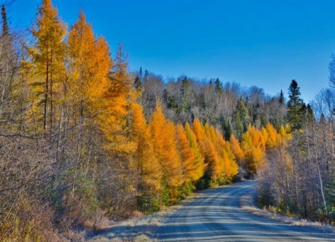
Victory Road, Victory Basin Wildlife Management Area. All photographs by the author.
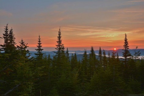
 Essex County is located in northeast Vermont. It is one of three counties that make up what is known as the Northeast Kingdom, named by Governor George Aiken in 1949. Essex County is the least populated county in New England, with just 6125 residents. There are a dozen or so towns in the county, only three of which have populations over 1000, the rest having populations of a few hundred or less. Almost all of these towns can be found along the paved perimeter roads that circle the county.
Take a drive along the only paved roads in the county (save one section of east-west road, Route 105, from Island Pond to Bloomfield) around the perimeter of 675 square miles of undeveloped wilderness and you will begin to appreciate how vast this 45-mile-long by 23-mile-wide section of Vermont is. Starting from Lyndonville in Caledonia County, head northeast on Route 114 to Island Pond, and continue north on 114 to the town of Norton on the Canadian border. There, Route 114 takes a 90-degree turn east, shadowing the 45th parallel of the Canadian border, to the town of Canaan. Canaan is on the border of New Hampshire, and here the Connecticut River divides the two states of Vermont and New Hampshire. At Canaan you will make another 90-degree turn and head south on Route 102, following the western shoreline of the Connecticut River, to the town of Lunenburg. Route 102 ends here merging into Route 2. Follow Route 2 west to the town of Concord to complete the circuit of Essex County.
I reference this circuit because there is so much acreage that cannot be reached by automobile, especially in winter but in summer as well. The good news is that within this circuit there is one paved road and a few gravel roads that are maintained year-round for access to some of the best birding locations in Vermont. In winter you will be able to access at least a few of the very best locations for finding boreal species and winter finches. In summer after mud season—usually around mid-May in Essex County—you will be able to access hundreds of miles of good hard-packed gravel roads to gain entry into the heart of The Kingdom. On most of these roads you will be able to use your family sedan without four-wheel drive.
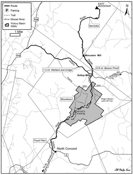
ESSEX COUNTY BIRDING LOCATIONS
Victory Basin Wildlife Management Area
Starting in St. Johnsbury from the Intersection of Route 2 and Route 5—also known as Railroad Street and Portland Street—drive east on Route 2 for about 11.5 miles to the town of North Concord at the intersection of Route 2 and Victory Road. (Note: Victory Road becomes River Road after 2.8 miles. All mile marker notations along Victory and River roads in this article refer to the start of this road in North Concord.) Make a left onto Victory Road, which becomes a gravel road after 0.2 mile of asphalt road, past the eight or ten houses and the post office that make up the town of North Concord. At about 0.7 mile, there is a flood plain on the left that in spring is usually flooded by snowmelt and rising waters from the Moose River. Park as far to the right as you can on this dirt road and use a scope to scan the field and river below. Look for several species of dabbling ducks as well as American Bitterns, Green Herons, Great Blue Herons, Belted Kingfishers, Wilson’s Snipe, and possibly a few shorebird species.
As you continue north on Victory Road during spring, summer, and into fall, you will undoubtedly hear several warbler species as you drive along. Feel free to stop anywhere along this road to search them out. Winter Wrens, Hermit Thrushes, Wood Thrushes, and vireos are found in good numbers. During the fall dozens of Northern Flickers forage alongside the roadway, and Ruffed Grouse are seen frequently along the road as well. In winter watch for flocks of Pine Siskins, Purple Finches, American Goldfinches, and Common Redpolls as they forage on the sanded roadways. Some years, you may see the occasional Red Crossbill or White-winged Crossbill.
I usually try to drive this road as early as possible in the morning. There is very little traffic to begin with but even less the earlier it is. I am often rewarded with catching good views of a moose as it saunters down the middle of the road. Other mammal sightings may include coyote, red fox, mink, river otter, black bear, and white-tailed deer.
Damon’s Crossing, Victory Basin Wildlife Management Area.
At about 3.0 miles, where you are now on River Road, just past a yellow farm house and red barn on the right are fields on both sides. A small wetland area with several snags is on the right. American Bittern has been found here as well as Merlin and Red-tailed Hawk. Wild Turkeys are usually on either side of the road foraging through the grasses. While you are here, check for sparrow species and, some years, Killdeer.
Damon’s Crossing
The actual border for the Victory Wildlife Management Area (sign post on left) is 3.8 miles in on River Road. There is a parking lot on the left at 4.4 miles where you can get the car off the road if you choose to bird here. I prefer to drive farther north to Damon’s Crossing at 5.5 miles. There is a larger parking lot on the left that is even plowed in winter months. Bog Brook flows under the small concrete bridge and merges with the Moose River on the right. This basin area of the Victory Wildlife Management Area is an excellent place to sit or stand in one place and bird. Beginning in early spring and through the fall, chances are you will find 25 to 35 species in an hour or so. The wide open expanse from the basin to the surrounding hardwood forests offers the opportunity to hear woodpeckers, thrushes, and warbler songs. Common Yellowthroats, Yellow Warblers, American Redstarts, and Chestnut-Sided Warblers breed here along with Least and Alder flycatchers. A few nest boxes supply breeding sites for Tree Swallows. American Bitterns can be seen and heard as well as a half-dozen Wilson’s Snipe. You can also hear and see Swamp, Song, and White-throated Sparrows.
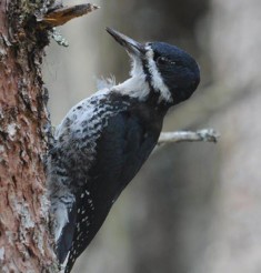
Black-backed Woodpecker.
Bog Brook floods in early spring, attracting Canada Geese, Black Ducks, Mallards, Hooded Mergansers, Common Mergansers, and Wood Ducks. By midsummer, dozens of Cedar Waxwings and a half-dozen Gray Catbirds forage on elderberry. As late summer approaches, Black-billed Cuckoos and Eastern Wood Pewees can be heard calling from the surrounding hardwoods. Rose-breasted Grosbeaks join the mix and forage on the berry bushes along the road. Some years, pairs of Cooper’s Hawks, Northern Harriers, and Merlins (which breed here regularly) fly over the basin. If you’re lucky you might even see a moose along the road here.
In winter, it can be pretty quiet unless it is an irruption year for winter finches. Blue Jays, Black-capped Chickadees, Hairy and Downy woodpeckers, Red-breasted Nuthatches, Purple Finches, and the occasional American Tree Sparrows watch over the refuge when all others have long departed for southern areas.
There is a trailhead at Damon’s Crossing marked by a kiosk. It follows along the former Moose River Logging Railroad line starting at Damon’s Crossing and runs in a northwesterly direction. A series of wooden planks help to traverse some of the wetter areas of the trail. This area can be wet in early spring and into summer. When mid-May rolls around, expect to be under siege from black flies and mosquitoes. (DEET or a head net is advised.) But if you get lucky and it isn’t as wet a spring as normal and there’s a slight breeze, this is a great trail for birding. Expect to find Yellow Warblers, Common Yellowthroats, Nashville, Chestnut-sided, and Canada warblers, American Redstarts, Black-throated Blue and Black-throated Green warblers, Gray Jays and Black-backed Woodpeckers. In spring look for Solitary Sandpipers, Great Blue Herons, and American Bitterns along the first section. The trail runs through a northern white cedar swamp and then enters coniferous forest consisting of balsam fir and black spruce. Black spruce is the preferred habitat for Spruce Grouse, Boreal Chickadees, and Black-backed Woodpeckers.
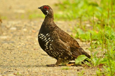
Spruce Grouse at The Blowdown.
Once you are out of the wetlands area, the trail is on slightly higher elevation—five or six feet higher. This is a great trail for hiking if you enjoy the northern forest. It meanders through a mix of habitats and eventually winds up at an old stone logging era dam that has long ago been breached by time and water. There are a few old stone foundations that were once part of a large logging operation a century ago. Once the trail exits the conifers I don’t find a great variety of species, although I do enjoy snowshoeing here in winter.
When you return to the Damon’s Crossing parking lot, you can leave the car and walk north along River Road and bird, or you can drive approximately one mile to The Blowdown.
The Blowdown
A mile north of Damon’s Crossing, or 6.5 miles in from North Concord, is the Victory Blowdown. The name was given to this area after a microburst storm knocked down 50 acres of conifers in 2010; Vermont Fish & Wildlife lists this trailhead as Guldenschuh Trail on some Vermont Fish & Wildlife maps. You access the area by an old logging road on the left side of River Road. Depending on weather conditions you can park in the log landing area a hundred yards into the Blowdown. I usually park on River Road as far to the right shoulder as I can. This is one area of Victory WMA where I have found all four boreal species: Black-backed Woodpecker, Gray Jay, Boreal Chickadee, and Spruce Grouse. It has taken many trips to this area to find all four; I’ve found Spruce Grouse here only once and Boreal Chickadee twice. Gray Jays and Black-backed Woodpeckers are common and breed here.
Moose River at Victory Basin WMA.
A note on Spruce Grouse: From 2008 to 2010, Vermont Fish & Wildlife reintroduced Spruce Grouse to Victory WMA. Approximately 134 birds were brought in from Quebec and Maine to try to establish a second location in Vermont. The other location for Spruce Grouse is in the Nulhegan Basin, which includes the Wenlock Wildlife Management Area and the Silvio Conte National Wildlife Refuge. Surveys in 2015 have shown that the Spruce Grouse are not doing as well as hoped. Two reasons may be predation or too little black spruce habitat for them to establish a healthy breeding population. I managed to see one male in the fall of 2015, so there are still perhaps a few birds out there.
This trail dissects a series of clearings, each of which can be exciting to bird. Expect to find Canada and Mourning warblers breeding here. Each year I manage to find at least one active cavity of Black-backed Woodpeckers here. White-throated Sparrows and Common Yellowthroats are found in good numbers. Last year Olive-sided Flycatcher bred here. Swainson’s Thrush is now breeding here, and this is one of two places in the Victory WMA to find Palm Warbler. I believe it breeds here now but have not confirmed it. Red-breasted Nuthatches, Brown Creepers, and Golden and Ruby-crowned kinglets are found in good numbers. Wood Thrushes and Hermit Thrushes can be heard singing.
The great thing about this area is that it is a condensed area to bird and it is also flat and easy to navigate. You can find many species in this one area of Victory WMA. In early spring you will be able to access areas of the clearings a lot easier than by late June when thickets and wild raspberry make traversing anywhere but the trail almost impossible. This is an excellent place during fall migration when Blackpoll, Bay-breasted, and Cape May warblers are foraging through the area.
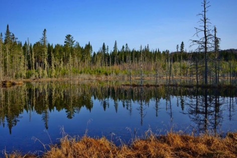
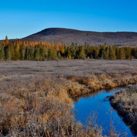
Beaver Pond along Pipeline East, Victory Basin WMA.
Black flies and mosquitoes can be abundant on summer days with no breeze. And each year more and more of the Blowdown area is filling in with new growth, changing the character of the habitat rapidly.
Continuing along the trail, you will enter an area of balsam fir, larch, and spruce where Black-backed Woodpeckers and Gray Jays are frequent. Black-throated Blue and Black-throated Green warblers are found along with Blackburnian Warblers. Listen for Brown Creepers, Winter Wrens, and Hermit Thrushes before the trail enters a more hardwood section of woods. At 1.5 miles, the trail enters wetlands that are part of the back of what is referred to as Victory Bog and, unless it is winter, the trail dead-ends. In winter, the wet area is frozen and you can intersect with the old railroad bed and take it back to Damon’s Crossing area if you are skilled with using a map and compass. Note: Victory Bog is a wooded swamp and not a true bog, because Bog Brook flows through the wetland.
The Blowdown is a good location for viewing moose, black bear, coyote, and plenty of red squirrel. At the entrance of the trail along the roadway check for mink and river otter in the eddies of the Moose River.
Leaving the Blowdown area and continuing north on River Road, you will come to a short dirt pulloff along the right side of the road in about 1.0 mile, or 7.5 miles in from North Concord. A local citizen sometimes hangs a feeder or two here and Gray Jays often come in for seed, especially in winter. The stop is a fine place to pull off the road and bird the roadway in each direction. As I mentioned before, at any location along the River Road you can find a variety of warbler and boreal species.
Oil Pipeline: East and West (The Pipeline)
At mile 8.7 along River Road is a concrete bridge over the Moose River. Access to the Pipeline West is on the left just before the bridge. For access to the Pipeline East, cross the bridge and in another tenth of a mile you will find a pair of yellow gates and the 60- to 80-foot-wide clearing running east and west. You can only access the Pipeline East from here as the Moose River blocks any westward movement. There is another set of yellow gates after you cross the bridge and before you reach the Pipeline East. This is the trail for Roger’s Creek/Lee’s Hill, and I will discuss this birding location after the Pipeline. Parking for these locations is as far right onto the shoulder of roadway as possible.
The Pipeline in Victory WMA refers to the Portland Pipeline, an underground system of three pipes that run from Portland, Maine, to Montreal, Canada. The 12inch, 18-inch, and 24-inch pipelines were built in 1941. German U-boats were sinking too many oil tankers bound for the St. Lawrence River, so a pipeline from Portland, Maine, to Montreal was a safer way to get oil to Canada. The River Road intersects this 236-mile-long pipeline at exactly the halfway point at mile 118. If you look in either direction of this clearing, you will see orange mile markers. The first one just off the road and east is mile marker 118. The 24-inch pipeline is barely in use today, although in 2002 it carried 418,000 barrels of oil a day to Montreal from 235 oil tankers. There have been proposals to reverse the flow and bring tar sands oil from Canada to Portland, Maine, but area residents are strongly opposed.
Pipeline East
The Pipeline East is one of my favorite birding locations during the spring. This gravel roadway is just wide enough for maintenance vehicles. It gently rises and falls for two miles, passing a handful of beaver ponds. This open route passes through a mix of conifer and hardwood forests and provides excellent viewing opportunities for a host of species, both avian and mammal. At the back of the first pond listen for Lincoln’s Sparrow, which I have found here several years in a row. The trail jogs to the left and passes through a mix of habitat where either Ruffed or Spruce grouse may be found. In fall, this section of the trail is good for migrating warblers. The trail then heads east and rejoins the cleared Pipeline area. On each crest of the small hills you can see for a mile in each direction, sometimes catching sight of moose or black bear in the open grounds between the forested sides.
For the first mile, each valley has a pond on the left side of the trail where a mink, muskrat, or beaver may be found. As you approach mile marker 117, another pond is on the right. Northern Waterthrushes are in at least a few of these pond areas. Wood and Black ducks, Canada Geese, and Hooded Mergansers use these ponds frequently. Kingfishers are here every year. You can find Gray Jays and Black-backed Woodpeckers at any location along this section of pipeline and, occasionally, Boreal Chickadees. This is probably the farthest south for the range of Boreal Chickadee, so finding one would be an excellent catch. Blue-headed Vireos, Nashville, Yellow-rumped, and Canada warblers breed here, as well as a few Palm Warblers. If you are lucky there is a chance that one of the released Spruce Grouse may still have some offspring along this trail. Depending on spring snowmelt and rain, some of the lower sections of the trail may be slightly flooded, so waterproof boots are advised.
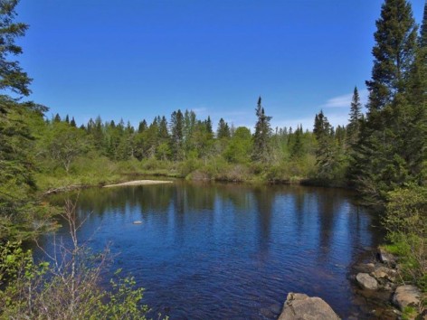
Pool along Roger’s Creek Trail, Victory WMA.
In winter the Pipeline East is used as a snowmobile trail and connects with the Pipeline West section across River Road. You may still walk and bird along the Pipeline, but when I do it is usually midweek when there is little snowmobile traffic.
Pipeline West
As I mentioned, the Pipeline West access is before the concrete bridge on the left. There is a set of yellow gates at the point of access. Spruce Grouse have been found here at the beginning of the trail. Golden and Ruby-crowned kinglets, Winter Wrens, and White-throated Sparrows greet you as you begin this section of the Pipeline. After a few hundred yards this access section will merge with the cleared Pipeline West trail area. As you follow the Pipeline west there are two beaver ponds on the right. Check for Solitary Sandpipers, Wood or Black ducks, or any surprise shorebird that may happen to be here in the spring. Swamp Sparrows and Song Sparrows are common. Merlins have nested here for several years, although I have yet to find their nest. In late summer, an adult swooped down from behind me three times, coming within a few feet of my head as a juvenile perched nearby. In April and May, you will most likely hear the drumming of not only Ruffed Grouse but also Black-backed Woodpeckers. As with the Pipeline East, this is a great trail for black bear and moose sightings. If you look west with your binoculars, you will see the orange mile marker 119 sign at the crest of the hill. As you can see, the habitat changes right about there from coniferous to hardwood forest. This is about as far as I take this trail.
Providing 10- to 20-acre clearings to create areas for Ruffed Grouse, Spruce Grouse, and American Woodcock to forage is part of the management plan in the WMAs. A new clearing was logged on the Pipeline West in 2015. It begins across from where the access trail meets the Pipeline. Look for a series of large boulders across the access to this clearing. Walk behind the boulders for about 300 yards and you will find what will be a great area for a variety of species for several years. In the spring of 2015, I found nesting Black-backed Woodpeckers, as well as Mourning and Canada Warblers. Broad-winged Hawks frequented the skies above. It is always exciting to watch as these clearings attract more and more species each year. Watch as new growth fills in, bringing with it a host of birding surprises.
Roger’s Brook/ Lee’s Hill Trail
This is the best trail in Victory WMA for a chance to see all four boreal species: Black-backed Woodpecker, Boreal Chickadee, Gray Jay, and Spruce Grouse. This was one of the areas used as a release site for the reintroduction of grouse in 2008–2010. Access to the trail is just north of the concrete bridge on the right side of the road and a hundred yards before the Pipeline. A yellow gate marks the start of the trail. Blackburnian Warblers are often found here in spring. A few hundred yards along this sandy trail is a clearing on the right. Lincoln’s Sparrows have been present for several years in a row and may be breeding here. As you begin this walk, Ruffed Grouse seem to be in good numbers for the first three-tenths of a mile. Once past the clearing on the right, you will come to a second gate and a more coniferous section of woods. Expect to find any of the boreal species for the next mile or so. In spring, you can hear any number of warbler songs along the trail; eventually Magnolia, Canada, Black-throated Green, and Common Yellowthroat predominate.
A small concrete bridge crosses Roger’s Brook, which soon merges with the Moose River. Kingfishers, Hooded Mergansers, Common Mergansers, and Spotted Sandpipers can be found in the pool just to the right of the bridge. Once you have crossed the bridge, you enter spruce-fir habitat where I have found Spruce Grouse on five occasions in 2010 to 2012. I often see or hear a couple of Black-backed Woodpeckers here in the spring. An opening will soon appear on your left, which is another clearing designed to regenerate spruce and fir. This area was cut in 2008 and is already filled in with new growth. Expect to hear or see Swainson’s Thrushes, Palm, Mourning, and Canada warblers, and possibly Yellow-bellied Flycatchers. There is a good chance to hear or see Olive-sided Flycatchers as well. When you come to the end of the clearing, the slight rise to the trail is good place to find Gray Jays. It is also a transition place between the coniferous woods and the beginning of a mixed hardwood forest.
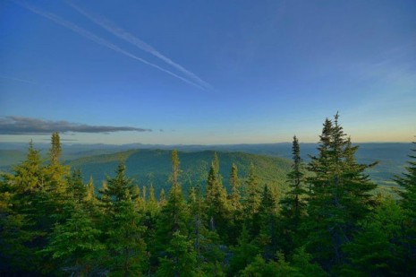
East Mountain Summit View.
If you choose, you can continue along this trail for at least another mile. You will come to a large clearing with a small camp. This land is in private ownership and is the end of the trail. Along the way possibilities include Scarlet Tanagers, Rose-breasted Grosbeaks and, of course, Red-eyed Vireos. Other hardwood species include Downy, Hairy, and Pileated woodpeckers, Brown Creepers, White-breasted Nuthatches, and Wood and Hermit thrushes.
In reality, every trail in Victory Basin WMA leads to a dead end. But just because you must return along the same way you came in doesn’t mean you won’t have a few new surprises along that same trail. Attempts at bushwhacking a route other than those already established should only be done by seasoned navigators of wilderness. I have often hiked off the trail following bird song and come back to the trail hundreds of yards from where I thought I should be.
When you return from exploring the Pipeline, continue driving along River Road. At 10.1 miles, you will come to the intersection of Victory Road, Granby Road, and River Road. This is the village of Gallup Mills. A left turn onto Victory Road will lead 7.7 miles out to Route 114. A right turn onto the Granby Road will take you through the village of Granby and out to Route 102 along the Connecticut River. Either of these roads is great for stopping any place to see what birds are in the area. In Gallup Mills, after you turn left on Victory Road, Radar Road is 0.1 mile on the right. I will talk about this section of Victory in the East Mountain description.
My suggestion is to head left at the intersection toward Route 114. At 0.8 mile from the intersection, you can park at a clearing on the left side of the road. There is a beaver pond a short walk ahead and good chances for Olive-sided Flycatcher, Northern Waterthrush, and other warbler and vireo species. Continuing the drive out to Route 114, at 1.5 mile from the intersection there is a wetland area on the right and an old logging trail on the left just after the small bridge. Park on the right shoulder, then walk down the logging trail for 400–500 yards to another beaver dam. A few duck species may be present as well as Spotted Sandpiper, Wood Thrush, and a handful of warbler species including Magnolia and Canada warblers.
If you like to find American Woodcock in spring, this 7.7 miles of road at dusk will yield several as they perform their aerial display flights. Take heed during mud season; this section of road can be several inches deep in mud. Four-wheel drive is a must during the spring thaw in April.
East Mountain: Bicknell’s Thrush
East Mountain Summit Radar Buildings.
From the intersection in Gallup Mills, Radar Road is 0.1 mile on the right after you turn left and head west toward Route 114. Pass the Victory Town Clerk’s office on the right and continue through the red gates along Radar Road.
I often climb this mountain during the first week of June. The optimal time to find Bicknell’s Thrush is from about 4:20 am to 5:00 am when they are singing and calling at first light. The grade up the mountain is moderate mainly because at one time it had to accommodate vehicle traffic daily to the Radar Base at the summit. This means I start at 3:00 am using a headlamp. The road up is wide and parts still have the 60-year old asphalt, making it a moderate hike. Give yourself at least an hour and a half from the mid-level barracks area to the summit.
Of course, Bicknell’s breed here, so you may be able to find or hear one any time of day; however, this is one of the locations for the Mountain Bird Survey, so using recordings and playback devices are not permitted. Familiarize yourself with Bicknell’s song and calls before you go. Playback devices and recordings may not be used at any time or place on any of the refuges and wildlife management areas in Vermont.
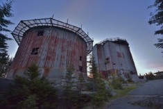
At 3438 feet elevation, East Mountain is one of the highest mountains in the Kingdom. In the mid-50s the U.S. Air Force chose the mountain as a site to build a radar base to detect missile launches and any attack coming from the Soviet Union during the Cold War period. About halfway up in a level area of the mountain, Quonset hut barracks and facilities for housing approximately 170 men were built. At the summit, several large concrete and sheet metal buildings with the latest technology for detecting possible missile launches were built. These became the ears for detecting any air activity over the North Pole. By 1963, the radar base had closed down. Today many structures are in place, although their innards were gutted long ago.
East Mountain Summit View
In 1961 the radar base detected an unidentified object, which many believe was a UFO. The Air Force never was able to confirm what they had detected for a period of 18 minutes. Just two hours later, Barney and Betty Hill of Portsmouth, New Hampshire, were driving through Franconia Notch in New Hampshire when they spotted what they later believed was a UFO. Barney and Betty Hill believed they were abducted aboard that alien ship that night and were the first people to report having been abducted by aliens. The Interrupted Journey, a book describing their nightmare, was published in 1966 and a television movie was made in 1975. Along Radar Road, 2.2 miles on the right along the Moose River, are the foundation and walls of an old mill known as Moccasin Mill. Pull over and check it out, keeping in mind that any time you stop along these roads there are birds waiting to be heard and seen. At 2.8 miles you’ll cross a wooden bridge over the Moose River.
For a side trip, take a right after the bridge and cross another wooden bridge, then climb a hill, bear to the left, and after 0.5 mile you will come to a T intersection. Take the right. After another 0.5 mile, there will be an old logging trail on the right along with two small ponds. These are nice to check out before continuing on for 0.6 mile to the upper beaver pond and wetland area that encompass both sides of the road. Cedar Waxwings, Spotted Sandpipers, Wood Ducks, and Blackpoll Warblers are just a few of the surprises well worth seeing. Total distance from Radar Road wooden bridge to upper pond is 3.6 miles. Return to Radar Road after this visit.
Continuing along the Radar Road, the Moose River will be on your left. There are gorgeous places to stop at several spots along this road and take in the small waterfalls of the Moose River. East Mountain contains the headwaters of the Moose River. The sound of the river may limit hearing bird song, but there is always the chance for mammal viewing. At 4.6 miles from the beginning of Radar Road, you will come to a set of gates. These should be open, but if not you’ll have to park at the small clearing on the left. If open, turn right and drive up the slope for 1.9 miles to the barrack base camp for the radar base. It is reasonably level here, so park off the main roadway; you will have to hike the remaining distance to the top. This location is 6.5 miles from the start of Radar Road.
The base camp is a great place to explore. Be careful of rusted metal and holes or pits that you may stumble into as you browse what used to be an old mess hall, bowling alley, theater, and housing for the men 60 years ago. Check for Least and Alder flycatchers. Blackpoll Warblers, and—depending on time of year—any other of 15 warbler species. You may find Lincoln’s Sparrows in the wetland just up the road and on the left. Fisher, white-tailed deer, moose, and black bear are possibilities on the climb up.
This is also the one location where you can get six thrush species as you walk up the mountain: American Robin, Hermit Thrush, Wood Thrush, and Veery at the lower elevations; Swainson’s Thrush in large numbers as you get in the 2500 feet elevation; and Bicknell’s Thrush at the summit. I’ve often had a dozen or more Swainson’s and sometimes four to seven Bicknell’s on a good morning. As daylight comes, Yellow-rumped, Magnolia, and a dozen Blackpoll warblers can be found. Add a few Yellow-bellied Flycatchers, a couple of Boreal Chickadees, and the occasional Gray Jay to the mix. In 2010 late one afternoon I also found one of the newly released Spruce Grouse females at 3400 feet, each of us surprised to see the other.
In the early morning, the summit is an eerie place to visit. Sheet metal on the remaining buildings bangs and clangs against the steel framing now rusted and deteriorating. It looks as if their listening equipment missed detecting an incoming missile and all that remains is the skeleton of the $21-million base (1950s cost). I can’t help but think about Betty and Barney Hill’s abduction and ponder the possibilities of that UFO returning! Be careful as you explore this environment: there are lots of hazards up here and you are a long way from medical attention. In a few of the concrete buildings, you can climb a story or two up to metal landings that give 360-degree views of the Northeast Kingdom. If you’re lucky, a Bicknell’s may alight onto a nearby spruce for excellent views. As you head back down the mountain most of the warbler species are now up and about while the thrush species are becoming less vocal.
The Vermont Fish & Wildlife Department offers a pdf brochure of Victory Basin WMA that contains an excellent map.
Thomas Berriman moved to the Northeast Kingdom of Vermont in 2002 after living in San Francisco for 25 years. Since then, he has spent a good deal of the time birding that area of Vermont. He is an Audubon chapter president and leads several field trips throughout Vermont each year. Over the last five years he has honed his skill in digiscoping the birds he finds.