Jason Forbes
Prospect Hill Park
 Prospect Hill in Waltham, rising to 485 feet, provides interesting birding for much of the year. Although close to downtown Boston, the change in elevation is enough to give a feel of areas farther to the west. The park covers 252 acres and includes several different habitats. For further details, check the eBird hotspot and the Waltham Land Trust’s guide.
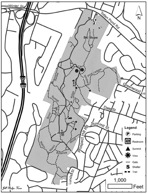
The main entrance is on the north border of the park at 314 Totten Pond Road, about a half-mile east of Exit 27—Totten Pond Road Winter Street on Interstate 95 (Route 128). This entrance is also accessible by bus on MBTA line 70. As you enter, you will see a parking area, then a small playground, and then another parking area next to the road leading up the hill. Unfortunately, the road is open to cars only from April through October, which means you will have to walk up the hill during the colder months. An alternative is to walk in from the southern, back entrance as described later in this article.
In spring and fall, migrant flocks of warblers can be everywhere. Just about every eastern warbler has been found, including several records of Hooded and Connecticut and a fall record of Cerulean. Other regular migrants include cuckoos, most vireos, and several flycatchers. Summer has a good mix of breeders including Great Crested Flycatchers, many Eastern Wood-Pewees, Wood Thrushes, Scarlet Tanagers, Chipping Sparrows, and abundant Pine Warblers, along with a few specialties described below. Winter can be a bit dull, but there is always a chance of winter finches, and it is worth searching for owls.
Prospect Hill
Because migrant flocks and most of the breeders can be found throughout the park, the loop described here covers only a few exceptional highlights. The full loop will take most of a morning and includes several steep areas. However, by driving up the hill in spring through fall, you can access most of the park with only a short walk. If you work nearby, a 30-minute to an hour stop at lunchtime could be almost as rewarding as a full circuit.
Starting from the rear parking lot at the base of the hill, check the trees and bushes on the right, which pass a small basketball court and lead into a little clearing. This corner had been the most reliable spot for Pileated Woodpecker in the park, but the trees have fallen over, so they are even more hit or miss now. Back to the left, the bushes at the bottom of the former ski slope are also worth checking.
There are three ways up the hill: the ski slope, the road, and the trail by the basketball court. The slope opens and has the best view of the sky for fall hawkwatching about halfway up by a stand of birch trees. The low brush along the slope provides a slightly different habitat from the rest of the park. I will describe the road on the way downhill. We will take the basketball trail to go uphill. This trail splits a short distance up the hill. Staying straight will connect with the ski slope at about the halfway point. Heading right will either make a slightly longer loop to the same spot or, if it isn’t overgrown, lead to a trail that you can follow almost to the top of the slope.
Walk straight up the basketball trail to where it rejoins the ski slope, where it is worth walking a short distance back down the ski slope. After checking the clearing just above the birch stand, retrace your steps, then continue up. The top half of the slope normally has several pairs of Indigo Buntings in summer, and you can often find some of the other forest breeders in the taller trees on the edge or hear them singing.
At the top of the slope, you will reach the road as it passes between two large water storage tanks. Check around both tanks. The first juncos of the fall are often here well ahead of other areas, and there are recent records of juncos oversummering. To the left, the paved Whitney Trail leads off to the southeast; follow it through the gate and down about a quarter-mile to the end.
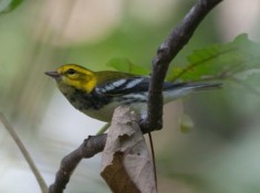
Black-throated Green Warbler, Prospect Hill. All photographs by the author.
At the end of the trail, there is a large communication tower—possibly to get even larger in the near future. You will find more Indigo Buntings here, and the early morning sun makes this a very good spot first thing in the morning. Slightly below the tower, one of two Worm-eating Warblers in the park set up territory in 2009.
After checking out the tower area, start back up the Whitney Trail. If you are up for a steep climb, look for the sign for the Pine Ledges Trail on the right. Do not take the trail at the sign, but continue to an unsigned trail about 50 feet farther. A small pile of rocks marks this trail, but if you can’t find it, take the labeled Pine Ledges Trail and walk along the left side of the stone wall until the trail becomes more obvious after a short distance. This trail leads to a staircase that heads down into a nice area with a stream and some extremely large pines. Black-throated Green Warblers have been on territory and Winter Wrens have been singing here on several occasions. For people who don’t want to deal with the stairs, you can drive up Bacon Street to Greenwood Lane, park at the corner of Cowassat Lane and Greenwood Lane, and walk in through there.
Return to the Whitney Trail and either take this trail back to the road or take the Ridge Trail up. Either way, you end up at Big Prospect, the higher of the two hills in the park. Common Ravens have been nesting on the old radio tower here for several years now and are likely to be nearby for most of the year. Also, here is the Sunset Shelter, which offers a decent view to the west, including some of the Cambridge Reservoir. There is room for several cars here, making it a good starting point for a short check when the road is open.
Turn south on the Ridge Trail to make the trip from Big Prospect to Little Prospect. At the low point between the two hills, the Valley Shelter will be on the right. A couple trails head left, but I generally just continue on the Ridge Trail, which heads back uphill toward Little Prospect.
About halfway up the trail, there is an unlabeled trail that leads off to the left and eventually reaches a sharp drop-off. This site gives a nice view of the tops of the trees below and is where the second Worm-eating Warbler set up a territory. Red-breasted Nuthatches have also been found around here in all seasons.
At the top of Little Prospect is a small rocky outcrop. Scan the skies quickly, but better views are found by walking down to the road and then out to the bench below. There is a tiny population of the state-listed red-bellied tiger beetle at this outcrop.
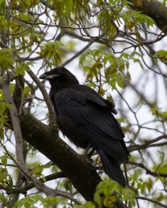
Common Raven, Prospect Hill.
There are two choices here: follow the Boston Rock Trail down to the Wood Trail from the bench or follow the road. We’ll follow the road. A short distance down, you’ll pass the Summer House shelter on the right and two bathrooms—the only ones in the park—on the left. Just ahead will be the gated road down to the back entrance. Either follow the road or walk off to the left and find the Summer House Trail, which has another steep staircase.
Continuing on the park road will take you past the Wood Trail and then to the southern back entrance to the park, which is on Prospect Hill Road near James Street. Parking is available on the street, but note that parking is prohibited near the gate itself.
From near this back entrance, take the Butterick Trail through an area that has several vernal pools and can be very productive. After about a quarter-mile, the Butterick Trail intersects with the Maloy Trail, which first starts in a southerly direction and then loops northward to follow the western edge of the park.
To return to the north entrance on Totten Pond Road, follow the Maloy Trail, which merges after about a half-mile into the Bond Trail and then a quarter-mile later into the Sunset Trail. An additional one third-mile on the Sunset trail will return you to the park road for the half-mile return to the north entrance and the parking lot. Along this route, there are also a number of smaller trails that lead back to the road between the Sunset Shelter and Summer House. Just before the Sunset Trail begins to pass some of the buildings from the office park, you can take a little walk off to the left and get another good view of the sky. This spot has been good for raptors. Depending on how far the construction of the shopping center below has progressed, keep an eye and ear out for Prairie Warbler, Brown Thrasher, Killdeer, and swallows.
Once the trail reaches the road, you can follow straight ahead to return to the parking lot. If you turn right instead, the next right leads south to the Valley Shelter and then loops all the way around back to Big Prospect. Going straight instead of right leads back to the water tanks and the ski slope.
Explore the hill. There’s always something of interest, whether you’re taking a quick trip along the road or hiking to the furthest corners.
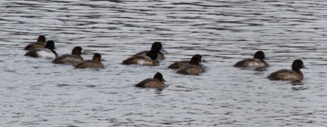
Greater and Lesser Scaup, Cambridge Reservoir
Cambridge Reservoir
The Cambridge Reservoir is about a mile west of Prospect Hill and is almost always worth a quick scan. The deep, southern end is one of the best sites around for diving ducks, grebes, and loons, and the northern end often dries out enough to be productive for shorebirds. Views of just about everything are distant, and a scope is a necessity.
The office parks along the reservoir make for quite a bit of traffic, so it can be difficult to bird during the work week, especially around rush hours. Weekends generally have little traffic, which means it is usually easy to pull over just about anywhere. Land off the road is marked no trespassing, so staying on the road is a requirement.
From the main Prospect Hill parking lot, take a left onto Totten Pond Road heading west and get into the right lane after crossing over Interstate 95. From the north, take Interstate 95 south to Exit 27B–Winter Street. From the south, take Exit 27A–Winter Street Totten Pond Road, take a right off the ramp, and then bear right and loop south on Wyman Street to Winter Street, where you should take a right to head west about a half-mile to the reservoir.
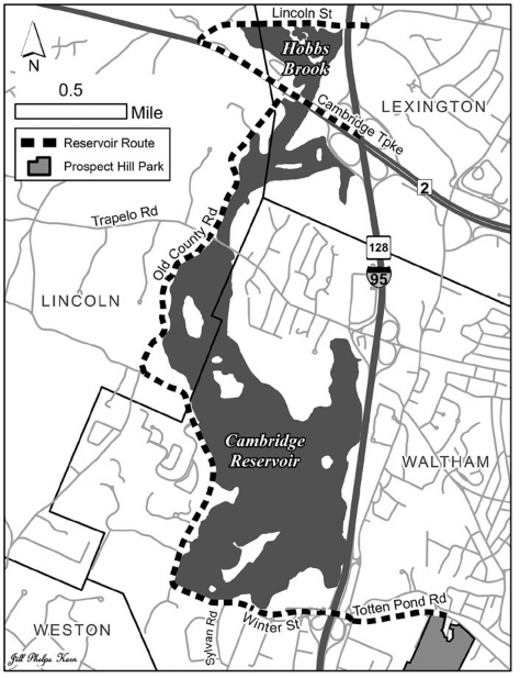
Cambridge Reservoir and Hobbs Brook
As the reservoir appears on the right, pull over opposite Sylvan Road if it is safe to do so. The rocks often have cormorants, and some of the diving ducks can be found here. If there is too much traffic to pull over along the edge, there is a dirt pulloff on the other side of the road, although you will have to drive some distance to find a safe place to turn around.
Follow the road—which goes across the Hobbs Brook dam at this point—as it bends sharply right and begins to head north along the western shore of the reservoir. A scaup flock often likes this corner in fall, but it can be quite difficult to find a safe vantage point. The trees then block your view for a short distance, but it will eventually open up. The recently added bike lane can make it easier to park and avoid traffic at all but the busiest times. However, do keep an eye out for bikes and joggers and do not drive in the bike lane. If stopping for a minute to scan, pull as close to the guardrail as possible to stay out of as much of the bike lane as you can. If you are going to take some time, it is better to park on the other side of the road, where there is a wider shoulder.
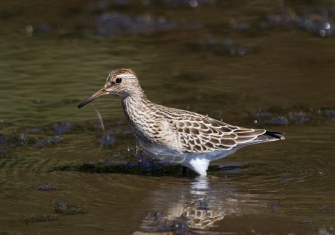
Pectoral Sandpiper, Hobbs Brook
As soon as you can see the water again, pull over. The area in front of the island is the best spot for loons, grebes, and scoters. For several years, Bald Eagles roosted in the big dead tree on the island. The tree has mostly fallen now, and the eagles don’t have any single roost but they can be found just about anywhere at any time of year. So far, there has been no sign of nesting, but it is expected sooner or later.
Continue north and pull over and scan wherever something catches your attention. The large flock of Ring-necked Ducks that builds over the fall can be anywhere on the reservoir and often attracts other waterfowl, with more than 30 species recorded. A big flock of coots also often builds up in fall. Terns and Bonaparte’s Gulls have occurred in spring and during storms in early fall. Spring can also bring in good numbers of swallows, although they often are too far out to see well. The reservoir does eventually freeze in winter, in which case it’s worth scanning the ice for ravens and eagles, especially if a deer carcass appears.
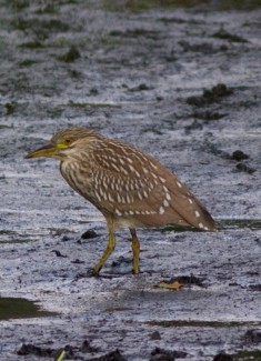
Black-crowned Night-Heron, Hobbes Brook.
Winter Street eventually enters woods, crosses into the town of Lincoln, bends left, and becomes one way. Take a right at the stop sign onto Old County Road, which is about a mile from the dam. If you feel like walking, especially in spring, there is room for a single car to park just after turning. Old County Road is narrow and winding, so be very careful if you decide to stop. My recommendation is either to take the spot at the stop sign or continue about three-quarters of a mile to park by Trapelo Road and walk from there if something is worth scoping. On days with bright sun, viewing can be even more difficult.
After going over two speed bumps, there is a gate just before Trapelo Road and enough room to park on the right. The Ring-neck flock sometimes is found here, and there are often good numbers of dabbling ducks around, mostly American Wigeon and occasionally Gadwall. The edges of the road can hold migrants as well.
Turning right on Trapelo Road will take you back to Route I-95, but you can also continue straight on Old County Road and scan more. About a quarter mile north of Trapelo Road, there is enough room to pull over. With the exception of this one spot, it can be difficult to find a good place to stop on this stretch of road, though fortunately there is very little traffic outside of the afternoon rush hour. Old County Road ends at Route 2 where the only option is to turn right for access to the eastbound lanes. Just before reaching Route 2, there is water on both sides that can be quite low and have shorebirds, but be careful when stopping here.
Across Route 2 is the section of the reservoir referred to as Hobbs Brook <http:// ebird.org/ebird/hotspot/L976923>. To reach it, take Route 2 west from Exit 28 of Route I-95 and turn right at the top of the hill on Lexington Road. After about 0.1 mile, bear right to continue heading east on Lexington Road, which becomes Lincoln Street at the town line. The reservoir will soon appear on the right, south side of the road. Either stop carefully right here; or drive a short distance farther, turn around at the first driveway, and park as close to the brush as you can; or drive to the overpass and park where the road widens then walk back. Traffic is not as bad as on Winter Street, but much of it is landscaping trucks, and the road is also popular with bicyclists, so be careful.
Walk along the road and check from several vantage points as birds can hide among the rocks. Peeps, Killdeer, and yellowlegs predominate but just about any shorebird is possible. Herons and egrets can also occur in numbers and American Pipits are frequent in fall. If there is more water and less mud, waterfowl can be of interest. Both Cackling and Greater White-fronted geese have occurred, and teal and Northern Shoveler are fairly regular.
On the north side of the road is a channel that often has Solitary Sandpipers and Green Herons. Also keep an eye on the trees and wires where many warblers, flycatchers, and swallows can perch.
As you continue to travel east on Lexington Road, the first driveway on the left on the north side of the road can be filled with sparrows, and the wooded area east of the houses often has more warblers. On the right, the south side, there is another area of the reservoir that can be filled with shorebirds, although it is very hard to scan without trespassing. Stick your head in at the used path at the concrete blocks on the south side of the road just beyond the houses.
As you near the overpass that carries Route I-95 over Lexington Road, you will have a bit of a view of the water and mud. Besides shorebirds, this area often has ducks. One year, a Yellow-crowned Night-Heron was briefly present. The bushes right at the overpass and the woods leading back are very good for warbler flocks at times.
To reach Route 2 westbound, you can return west on Lexington Road. Alternatively, to reach Route 2 eastbound or Route I-95, just continue east on Lexington Road–Lincoln Street. Stay left at the fork and continue on Lincoln Street until you reach Marrett Road–Route 2A. From this intersection, you can either turn left to reach Route I-95, or turn right to follow Route 2A to the intersection with Spring Street, where another right will return you to Route 2.
Both ends of the reservoir are easily accessible and easy to check quickly. There may not be something every time, but conditions can change daily, so frequent visits are rewarding.
Jason Forbes is a lifelong resident of Waltham. He’d rather be birding than driving and therefore spends most of his time locally. He is almost at his goal of 300 species within two towns of the Waltham/Lexington line.