Nate Marchessault
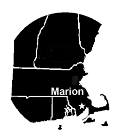 North of Allens Pond, south of Myles Standish State Forest, and east of the Assawompset Pond Complex lies an area in southeastern Massachusetts that is not often birded. Locals call it the Tri-Town area, and it comprises Marion, Mattapoisett, and Rochester. These towns were all part of Rochester until 1852 when Marion became a separate town. Five years later, Mattapoisett separated as well. Marion was once home to many wealthy sea captains, Mattapoisett became known as a town of shipbuilders, and Rochester a town of farmers and loggers. Marion and Mattapoisett lie along the coast of Buzzards Bay, with Marion north of Mattapoisett. Rochester is a landlocked town west of Marion and Mattapoisett.
Due to this area’s proximity to the ocean and its many peninsulas—or necks—that jut out into Buzzards Bay, the Tri-Town area generally experiences cooler temperatures than surrounding areas in summer, and warmer temperatures in winter. The sheltered nature of Buzzards Bay affords moderate protection from storms coming in from the ocean, and the seas are typically less rough than the nearby areas outside the bay. When birding early in the morning in this area, it is not unusual to be greeted by a sunrise over an ocean of glass.
This article is a year-round guide to the area, although it is worth noting that some overarching themes apply to the entire region in terms of seasonality. This area truly shines in the winter. With generally mild winters, the Tri-Town area is attractive to many semi-hardy thicket birds and other winter lingerers. Fall can also be productive, with reasonably good duck, goose, and sparrow diversity. In summer, the area hosts rare breeders such as Saltmarsh Sparrows, a fairly numerous population of American Oystercatchers, and two major Common and Roseate tern colonies.
Spring is a season that requires reasonable expectations in order to be fully appreciated. The Tri-Town area seldom experiences spring migration the way some other nearby locations do. It has few migrant traps and lacks the numbers or diversity of nearby inland locations such as Lakeville, the Bridgewaters, or Middleborough. If you don’t mind seeing fewer passerine migrants and get excited by the sight of a Northern Parula, Chestnut-sided Warbler, or Magnolia Warbler, then you will be sure to have an enjoyable time tracking the return of the various breeding species in the area.
Since the area currently does not receive much birding traffic and because many new trails and areas of conservation have opened up recently, I will offer some selected bird records from my own expeditions and those of other frequent visitors. It is worth visiting the region with an open mind because you never know what you might find. I have discovered many locations in my ventures that have been quite productive for birds, and surely there are many more to find. Several resources for finding and exploring new locations are available online by visiting the websites of the Buzzards Bay Coalition, Mattapoisett Land Trust, Rochester Land Trust, Rochester Conservation Commission, Sippican Lands Trust, and Wildlands Trust.
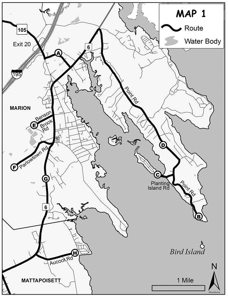
Although there are many scenic back roads to get to the Tri-Town area, the quickest way is to take Interstate 195 (I–195). Exit 20 will put you on Route 105 in Marion, which is where we’ll begin birding the Tri-Town area. See Map 1. When you get off at Exit 20, turn right onto Route 105 (Front Street) and head south for 0.2 mile, then turn left at the sign to Washburn Park (A). Drive to the end of the paved road to the small dirt parking lot. You can download a trail map. The open field is a good spot to see Eastern Phoebes catching flies along the fences at the edge of the ball fields, and may prove to be a decent spot to observe American Woodcocks displaying at dusk in the spring.
There is an entrance into the woods adjacent to the parking lot. Walk along the wooded trail, cross the power line cut, and make your way to a small bog pond. This is generally the most productive area for finding birds. In spring and fall this pond has attracted Blue-winged Teal and Northern Pintails, among other ducks. The small island on this pond hosts an active Osprey nest, as well as a few Great Blue Heron nests. This is a good spot to bring a scope to observe these species nesting at close range. Belted Kingfishers and Tree Swallows often use the dead trees as perches since they offer such commanding views of the pond. In the winter this can be a fairly quiet spot, although encountering a Hermit Thrush or Winter Wren is not unprecedented. If the pond remains unfrozen, it can host Ring-necked Ducks, Buffleheads, Hooded Mergansers, and other dabblers and divers. The trails back to the parking lot consist mostly of pine and mixed hardwoods, and the woodland regularly hosts Red-bellied, Downy, and Hairy woodpeckers, Eastern Wood-Pewees, Great Crested Flycatchers, Brown Creepers, and Pine Warblers, depending on the season.
Instead of leaving the park on the paved road you came in on, turn left and follow the dirt road as it curves around the ball fields, then drive straight to Route 6. Turn left onto Route 6 (Wareham Road), and at the first set of lights turn right onto Point Road. Drive 4.5 miles to the end of the road to the Kittansett Club (B). Drive into the club’s parking lot and take a right to park in the grassy portion of the lot. Bear in mind that the management is kind enough to allow birders to park here and bird this area, so please be respectful when visiting. If there is a function or event going on, or if the parking lot is somewhat full, turn around and visit another time. Follow the trail at the edge of the grass to an open area with views of Bird Island. In spring and summer, this island is host to hundreds upon hundreds of Common and Roseate terns, which is truly a sight worth seeing. In winter, this is also one of the better spots in the area to scope the bay. Common Eiders, Surf Scoters, Black Scoters, Long-tailed Ducks, Red-breasted Mergansers, Red-throated and Common loons, Horned Grebes, and Great Cormorants are relatively common here, and occasionally you can see a small group of Razorbills. Before returning to your car, walk over to the paved portion of the parking lot and scope from there for another vantage point of interior Buzzards Bay.
Return to Point Road and drive for 1.0 mile, turning left onto Planting Island Road (C), which has parking areas along the road. This is another location worth visiting in winter, since it provides good views of Planting Island Cove and Sippican Harbor. The ocean here attracts many of the same species found at the Kittansett Club, and you can find large numbers of Greater Scaup and sometimes a Northern Shoveler or two on Planting Island Cove. This is solely a winter birding location because in summer the parking areas are for residents only.
Return to Point Road and head back toward Route 6. In fall and early winter, keep your eyes open for thickets along this road, as several roadside thickets have from time to time yielded Yellow-breasted Chats. On the left in 0.5 mile there will be a sign for Osprey Marsh (D), which also can be good for winter lingerers.
Turn left onto Route 6 and drive south for 2.0 miles, then turn right onto Benson Brook Road. The Marion Water Treatment Plant (E), which is one of the better birding locations in the area, is at the end of this road. This area is fenced and gated and is only accessible during normal transfer station hours. The hours as of September 2017 are Tuesday through Saturday 8:00 am to 4:00 pm and Sundays from 9:00 am to 1:00 pm. These hours are subject to change, so check the Town of Marion website. Drive all the way to the end of the road and park out of the way in the large dirt area where people drop off compost. In fall and winter, the plant’s retention ponds hold an impressive number and diversity of duck species. For the best vantage points, walk up to the top of the compost piles to view the closest two retention ponds or walk through the woods at the end of the dirt parking area to view the third pond. You can find Gadwalls, American Wigeons, Blue-winged Teal, Green-winged Teal, Northern Pintails, Hooded Mergansers, and Ring-necked Ducks. This is a consistent location to find a few Northern Shovelers. Eurasian Wigeons have also appeared here, so it may pay to look at the wigeons carefully.
The water treatment plant is productive for more than ducks. The tree line along the parking area and the thickets near the office can be great in the winter, when you can consistently find Winter Wrens and Fox Sparrows, and occasionally a Hermit Thrush, Gray Catbird, or Eastern Towhee. In fall, the weedy growth near the parking area can be a great spot for sparrows and warblers; Connecticut Warblers, White-crowned Sparrows, and Blue Grosbeaks have been seen. In spring and summer, there are a surprising number of breeding warblers and other passerines. Wood Ducks and Double-crested Cormorants inhabit the ponds, and a Belted Kingfisher can often be heard or seen hunting around the ponds. In May of 2017, a Cattle Egret was observed associating with the farm animals near the office area.
Return to Route 6 from Benson Brook Road, turn right, drive 0.5 mile, and where the road starts to bend, take a quick right onto Parlowtown Road. At the end of the paved road, turn left onto a dirt road. Following the dirt road leads to Goldavitz Bog, a Town of Marion property, and eventually to the White Eagle Property (F), owned by Sippican Lands Trust. You can download a map. Goldavitz Bog is a relatively small overgrown bog, where Sora and Virginia Rail have been found in the spring. The bog also hosts Tree Swallows, Common Yellowthroats, Swamp Sparrows, and Red-winged Blackbirds throughout the year.
White Eagle Property consists of extensive trails through mostly white pine forest. It also has a large working cranberry bog that contains several retention ponds along the borders. If you are lucky, the parking area here can be a great spot to hear duetting Veeries and Wood Thrushes in season. Walking the trail into the woods from the parking area leads to a small boardwalk over a stream, where you might hear and (if lucky) see a Winter Wren in early spring. Beyond the boardwalk, an expansive network of trails eventually connects to the Benson Brook Road parcels and the Marion Water Treatment Plant.
The woods here are home to common breeders such as Black-and-white Warblers and Eastern Towhees, but generally are not diverse in terms of bird species, likely due to the lack of understory and diversity in tree species. The bog area can be a great place to photograph Tree Swallows, as there are several nests along the trails, and the ponds may hold ducks and shorebirds in spring and fall. Wood Ducks are likely breeders in the area, and Buffleheads occasionally show up in the winter if the ponds remain unfrozen. Killdeer, Least Sandpipers, and Spotted Sandpipers are the most common shorebirds here, but occasionally Semipalmated Plovers, Semipalmated Sandpipers, Solitary Sandpipers, and Pectoral Sandpipers show up as well. In the early spring and fall, when walking along the bogs it is not unusual to flush a snipe or two from the ditches.
Returning to Route 6 from Parlowtown Road, turn right, and drive for 0.75 mile. On the left will be a shop (currently called Fieldstone); right after it and just before a guardrail is a nondescript dirt road on the right. Take this short dirt road and park off to the side. This is Grassi Bog (G), where I have never seen another person despite its proximity to a major road. This area has several overgrown bogs and retention ponds. In 2017, the Town of Marion altered the water flow through the bogs as part of the Grassi Bog restoration project, which may impact which species may be here in the future. Historically, Virginia Rails have been here in breeding season, as well as Wood Ducks, Ospreys, Red-shouldered Hawks, Eastern Phoebes, Common Yellowthroats, and Swamp Sparrows. Once, a Marsh Wren was observed here in late February. Grassi Bog could benefit from more birding coverage in order to learn which species migrate or reside here. For those who enjoy occasional solitude, it can be a great place to get away from people for a while.
Be cautious when you pull back out onto Route 6. Drive south, and in 1.5 miles turn left on Aucoot Road shortly after Old Rochester Regional High School. About 0.5 mile down Aucoot Road is a small horse pasture (H). You can park off the road and check out the thickets and woodland. The thickets across the street and at the end of the pasture have yielded Hermit Thrush, Gray Catbird, Eastern Towhee, and even a wintering Brown Thrasher. Just as the road begins to curve left, turn right onto a dirt road that leads to a small beach that is worth checking for sea ducks in winter. Please note that in summer these roads are much more heavily trafficked and the beach has resident-only parking restrictions.
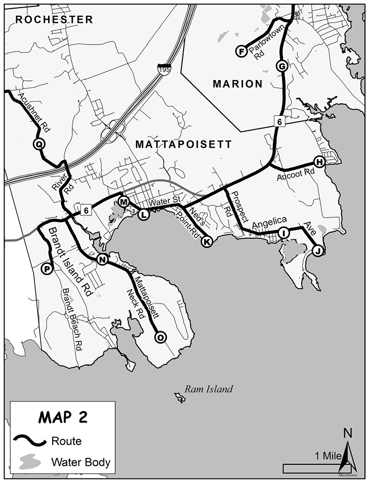
Drive back to Route 6, turn left, and in 0.75 mile, turn left again onto Prospect Road. See Map 2. Prospect Road turns into Angelica Avenue. Keep driving until you come to a stream flowing under a small stone culvert. Find a place to park off the road on either side of the culvert. You can view Pine Island Pond (I) from the edge of the road or you can walk into the marsh. You will usually see American Oystercatchers, Willets, and Greater Yellowlegs, particularly on the large sand spit protruding into the pond from Pine Island. On the opposite side of the road, a small trail follows a brackish stream into the woods that can be good for chickadee flocks and other species that associate with them in fall and winter.
Drive to the end of Angelica Avenue. There will be a sign on the right and a dirt road for Angelica Point (J). This road is private but open to foot traffic. There is room to park one car next to this sign, and it is best to let any passengers out on the passenger side before parking in order to get off the road as much as possible. Walking down the dirt road, you will come to several spots that have views of Pine Island Pond. In fall, winter, and spring, look for Ruddy Turnstones and Dunlin on the nearby rocks. Continuing up the road, you will pass a marsh where you can frequently find Ospreys, Great Blue Herons, Great Egrets, and Willets. Beyond the parking area for the last house at the end of the road, you will come to a narrow path. This path leads to the edge of Pine Island and Angelica Point, which is one of the better shorebirding spots. Although bird numbers are not as high as at Plymouth Beach, the diversity is good. On lower tides, you can wade through the stream that leads into the marsh onto Pine Island. Follow the edge of the marsh where there are a few small salt pans that attract shorebirds. This portion of the marsh also hosts Saltmarsh Sparrows in the breeding season.
If you don’t cross the stream, walk along the path to Angelica Point. The sandy area to the right of the narrow path leading toward the peninsula is a good spot for American Oystercatchers, Piping Plovers, and Greater Yellowlegs. Left of the path you can sometimes find White-rumped Sandpipers, Short-billed Dowitchers, and other common peep species. Continuing left where the beach splits leads to a small salt marsh with an equally small salt pond. This area usually has a fairly high density of breeding Saltmarsh Sparrows. The salt pond may hold shorebirds in the spring and fall, and occasionally Gadwalls will use the pond in winter.
When you finish birding Angelica Point and Pine Island, drive back to Route 6 via Angelica and Prospect roads. Turn left, and in approximately 0.25 mile, turn left at the fork at Oxford Creamery to remain on Marion Road. At the stop sign, turn left onto Ned’s Point Road and drive to Ned’s Point Lighthouse (K). This location has good views of most of Mattapoisett Harbor and some of Buzzards Bay, so it can be a worthwhile stop in the winter for sea ducks and other ocean-loving species such as Great Cormorant. Mattapoisett Harbor accumulates large flocks of Surf Scoters and Long-tailed Ducks in the winter and regularly hosts hundreds of Greater Scaups. Around dusk the ducks fly to their night roosts on the ocean, which creates quite a spectacle. Ned’s Point Light is probably the best location to observe these evening flyouts. Parking here is free year-round, and there are restrooms open in the summer; however, the birding is best in winter.
Returning up Ned’s Point Road, drive straight past the stop sign onto Beacon Street—which becomes Water Street— for 0.5 mile, and take a left onto the town wharf (L) for views of Mattapoisett Harbor. This is a great spot for a window-mounted scope and a hot cup of coffee on a cold winter’s day. Along with the aforementioned species, Hooded and Red-breasted mergansers as well as the occasional Common Loon often swim right along the wharf, giving close views.
When leaving the wharf, turn left onto Water Street, which soon becomes Main Street. In 0.25 mile, turn left onto Depot Street, which ends at a large parking lot. Park here and walk down Goodspeed Island Road to get to Eel Pond (M), a large salt pond that feeds into Mattapoisett Harbor, and a small beach. In summer, the mouth of the river is a great spot to observe American Oystercatchers feeding. Walking the short trail along the river, you will frequently see a Green Heron or two. In May 2014, Clapper Rail was heard in this marsh; in August 2016, several juvenile Yellow-crowned Night-Herons were feeding in the marsh throughout the entire month. In fall, this area doesn’t pick up many shorebirds, but will often attract a Spotted Sandpiper or two, and occasionally high numbers of Greater Yellowlegs. Normally, you’ll see a few Great Blue Herons and Great Egrets, but occasionally in migration many of these birds will pass through the marsh. In winter, Dark-eyed Juncos and Yellow-rumped Warblers are common in the cedars. A pair of Gadwalls is almost always present in the pond. The small thicket in the parking lot and another shortly after the entrance to Goodspeed Island Road can be productive for Fox Sparrows. In late winter, there is a blackbird roost in the phragmites near the entrance, and large numbers of Common Grackles and Red-winged Blackbirds will fill the trees at dusk, their chorus a welcome reminder that spring is not far.
Head out of the parking lot on Railroad Ave and turn left onto Route 6 (now Fairhaven Road). Drive for a mile and turn left onto Mattapoisett Neck Road. In 0.75 mile, there is a boat ramp (N) that is another good spot to scope Mattapoisett Harbor in winter. Large numbers of ducks—often including Gadwalls and sometimes Northern Pintails—and occasionally geese sometimes roam around the sand spit opposite the boat ramp. Drive down the road to Molly’s Cove along the right-hand side of the road and check for shorebirds and waders. In 2016, there were a few juvenile Yellow-crowned Night-Herons here in August, and I have heard Clapper Rails calling in these marshes.
Follow Mattapoisett Neck Road until it ends at a parking area on the right. Do not drive beyond the stone pillar onto Antassawamock Road. Park here, which is the access to the Munn Preserve (O), recently acquired by Mattapoisett Land Trust. You can download a map. A short path through mostly deciduous woods leads out to a strip of beach that overlooks Brandt Island Cove and Buzzards Bay. This is a great location in the summer to bring a scope and observe Ram Island, which is host to hundreds of nesting Common and Roseate terns, clouds of them occasionally filling the sky, their calls audible from over a mile away. The narrow strips of marsh along the beach are home to breeding Saltmarsh Sparrows, and this is a good location to see American Oystercatchers. In fall, the small marsh supports a reasonable diversity of shorebirds, and in 2016, a Tricolored Heron was seen here. The number of Ospreys is spectacular—careful observation can yield more than 20 in one visit. In winter, this is also a decent spot to look for sea ducks. The woods here are home to many breeding species; White-eyed Vireo has likely bred here in the past. Yellow-bellied Sapsucker has also been heard in early spring. This is truly one of the great spots in the Tri-Town area and should not be missed.
Go back up Mattapoisett Neck Road, turn left onto Route 6, and proceed for 0.5 mile before turning left onto Brandt Island Road. Drive 1.25 miles until the road forks. Stay to the right and look for signs for Nasketucket Bay State Reservation (P). You can download the reservation’s trail map. This park has many different habitats: mixed forest, extensive secondary growth, thickets, open field, a beach that overlooks Nasketucket Bay, and a small salt marsh. Birding here can be good any time of year, although it is truly fantastic in the winter. It is open to hunting, so be sure to wear orange if birding during hunting season. Walking the main trail (Bridle Trail), turn right onto the Meadow Trail and continue to where the path turns left and begins to open up at some thickets. This area has yielded Winter Wrens, Hermit Thrushes, Gray Catbirds, Fox Sparrows, and Yellow-breasted Chats in winter, and is a great spot to observe Blue-winged Warblers in spring. The field along Meadow Trail is where I often hear my first Baltimore Oriole in spring and is a great spot to observe displaying American Woodcocks. For those interested in butterflies, this field is particularly good in summer and early fall.
The Meadow Trail reconnects with the Bridle Trail. Continue along this trail. I have encountered Fox Sparrows along the edges of this part of the trail in winter. The sounds of catbirds mewing and towhees scratching in the leaf litter is omnipresent in spring and summer. You can hear Wood Thrushes frequently throughout the reservation, as well. Eventually the Bridle Trail forks. Go right along the Saltmarsh Trail, which will lead out to Nasketucket Bay. This is another spot worth checking for sea ducks in the winter. In summer, the marsh to the right from the entrance to the beach is a spot where Saltmarsh Sparrows likely breed. At the end of the Saltmarsh Trail, return along the Holly Trail, which will take you back to the meadow and Bridle Trail. Along the way, you can hear Scarlet Tanagers in spring and summer, and Brown Creepers year-round in the conifers.
When you get back to Route 6 from Brandt Island Road, turn right. Drive for about 0.5 mile and turn left onto River Road just before the Mattapoisett River. Carefully cross the one-lane bridge over the river, and turn left where the road ends at Acushnet Road. After passing over Interstate I-195, turn left to continue on Acushnet Road. In a little over 0.5 mile, there will be a sign and parking for The Bogs (Q), a property owned by Buzzards Bay Coalition. This can be a productive spot for hawk watching in spring and fall. The key is to bring a scope and a chair. If you set up in the parking lot or along Acushnet Road, these treeless old bogs provide open views of the sky. Although The Bogs cannot compare with locations in western Massachusetts, you can get decent raptor diversity. It is a particularly good spot on a warm windy day to watch for migrating hawks and is one of the most reliable locations in Plymouth County for Black Vulture. You can encounter a surprisingly high number of species just sitting here for a while; 40–50 species are not unprecedented for an observer with keen eyes and ears.
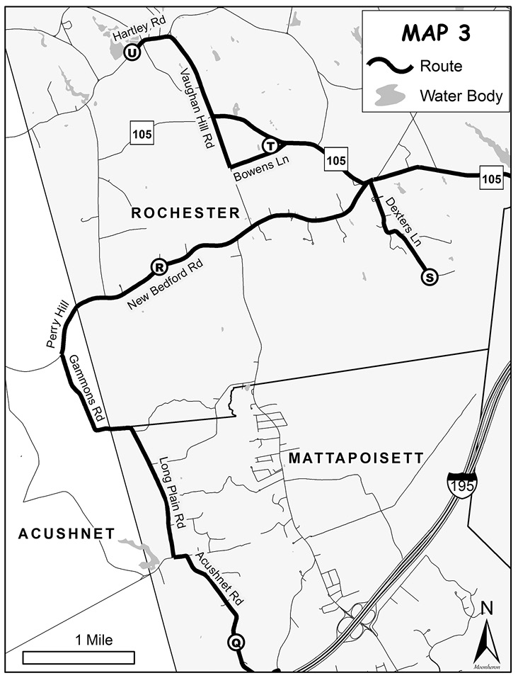
Drive north on Acushnet Road. See Map 3. Turn left where the road ends at Tinkham Lane, then take a quick right onto Long Plain Road. Follow this road—which curves sharply to the left and then sharply to the right (where it becomes Gammons Road in Bristol County)—for approximately 2.25 miles to the end. Turn right onto Perry Hill Road (which will shortly become New Bedford Road in Plymouth County). In 1.5 miles, you will come to a Mattapoisett Land Trust sign and small parking lot on the right. Known as the Shoolman Preserve (R), this is a loop trail through mixed forest that has a healthy understory, with two offshoots that feature scenic views of the Mattapoisett River and large holly trees. You can download the trail map. This is a particularly good spot for an ear tune-up in the spring to compare Pine Warbler and Chipping Sparrow songs and the diverse repertoire of American Redstarts versus Yellow Warblers. You will see and hear large numbers of American Redstarts and Ovenbirds in the breeding season. Canada Warblers have been heard here and are possible breeders. The preserve also hosts Ruby-throated Hummingbirds, Brown Creepers, and Scarlet Tanagers, as well as many common forest-loving birds.
Drive east on New Bedford Road for two miles, and take a sharp right onto Dexter Lane. Drive to the end of the road to the entrance of Haskell Swamp Wildlife Management Area (S), an area of more than 3,100 acres of coniferous and hardwood forests. The main trail here is wide and occasionally wet, with several offshoot trails that eventually peter off due to downed trees. In spring, you can often hear Winter Wrens and Northern Waterthrushes, and a Barred Owl may respond to imitated hoots. The sound of singing Ovenbirds is almost ubiquitous throughout this forest. Hermit Thrushes are also present in the breeding season, and a few may linger here in winter. In 2017, a pair of Sharp-shinned Hawks showed up in the summer, indicating possible breeding. This WMA is a huge area with many trails to explore and certainly many interesting birds to be discovered.
Drive back up Dexter Lane and turn left onto Route 105. Proceed for about 1.0 mile until you reach a large farm field on the left. This area is part of the Vaughan Hill Road fields (T), a complex of fields known for their large numbers of geese, including the occasional rarity almost every year. The best way to bird this area is to drive along the triangle of roads surrounding it: Route 105, Vaughan Hill Road, and Bowens Lane. These fields are quite hilly, so you will need to observe them from multiple vantage points to get decent coverage. Parking on the street is allowed, but be sure to safely pull all the way off the road and use extreme caution if it is wet so you don’t get stuck. Parking at the entrance to the Rochester Golf Club is an option in winter. In fall, winter, and early spring, the goose flocks here have included Greater White-fronted Goose, Snow Goose, and Cackling Goose. The fields, once plowed, have also hosted Sandhill Cranes, wintering Eastern Meadowlarks, and large numbers of Killdeer. In spring, the wet fields attract dabbling ducks including Wood Ducks, American Wigeons, Gadwalls, American Black Ducks, Mallards, Northern Pintails, and Green-winged Teal. The small puddles in the middle of the field may hold shorebirds such as Wilson’s Snipes, Spotted Sandpipers, and Greater Yellowlegs. The small farm pond on the opposite side of Route 105 has occasionally hosted Blue-winged Teal; when the water level is low, it can be surprisingly productive for shorebirds such as Solitary Sandpiper, Lesser Yellowlegs, and peeps in the fall.
From Route 105 turn right onto Vaughan Hill Road, where more farm fields are worth checking for geese. At the fork toward the end of the fields, bear left onto Hartley Road, bear left at the next fork, and continue to the parking lot for Hartley Reservoir at the Rochester Wildlife Management Area (U) on the right. You can download a map. This is a complex of manmade ponds that were formerly cranberry bogs with a trail around the perimeters of the ponds. In breeding season these ponds are home to Wood Ducks. Hooded Mergansers have bred here in the past, although probably only sporadically. In fall, winter, and spring, the ponds may also host waterfowl such as American Black Ducks, Blue-winged Teal, Northern Shovelers (rarely), Green-winged Teal, Ring-necked Ducks, Lesser Scaups, Buffleheads, and Pied-billed Grebes. In spring and summer, you can hear Warbling Vireos throughout this area. On a cool or cloudy day, swallows and swifts feed low near the surface of the ponds. There is a blackbird roost in the phragmites patch in the woods at the end of the central trail, where you can occasionally find Rusty Blackbirds in the spring.
This is the end of the Tri-Town birding trail. To return to I-195, drive back down Hartley Road, turn right on Vaughan Hill Road, and turn left at the stop sign onto Route 105.
My suggestions are snapshots of the locations worth birding in the area, and careful exploration may yield a discovery of something unexpected. What the Tri-Town area lacks in migrants, it more than makes up for in breeding and wintering birds. Complementary to this is the opportunity to delve into uncharted territory. The area is like a treasure chest, waiting to be discovered!
Nate Marchessault is an avid birder from Mattapoisett, Massachusetts. In 2016 he did a Plymouth County Big Year, where he frequently traveled out of the Tri-town area to chase after rare birds. Currently, he enjoys birding locally and leads trips for South Shore Bird Club and Buzzards Bay Coalition.