Jason Forbes
 The Western Greenway is a planned loop through approximately six miles of open space through Belmont, Waltham, and Lexington. Rock Meadow and Habitat, both in Belmont, are the best known of the various pieces, but the best birding overall may be at the Beaver Brook North Reservation. The reservation features a variety of habitats, although it has minimal pond and shorebird habitat. Even with that limitation, the list of birds seen is well over 150 (see the eBird hotspot for most of the records).
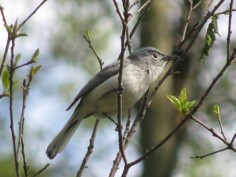
Expected breeding birds include cuckoos, Blue-winged Warbler, Blue-gray Gnatcatcher, and the usual forest birds, such as Great Crested Flycatcher, Eastern Wood-Pewee, Wood Thrush, Scarlet Tanager, and Rose-breasted Grosbeak. Expected wintering birds include good numbers of American Tree Sparrows, Rusty Blackbirds, Winter Wrens, and finches in flight years. During migration, expect just about anything.
The reservation is owned primarily by the Massachusetts Department of Conservation and Recreation (DCR) but includes several pieces of town-owned conservation land as well. It was the site of the former Metropolitan State Hospital, and many pieces of that history are still visible. Most of the buildings have either been knocked down or turned into part of the Avalon apartments, but the McLaughlin Building is still standing and the MetFern Cemetery still exists.
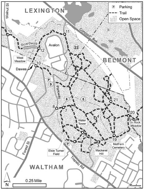
Beaver Brook North and the adjacent Rock Meadow are more or less bordered by Trapelo Road to the south, Mill Street to the east, Concord Avenue to the north, and Lexington and Waltham Streets to the west. There are access points from most of those streets, but the main points are along Trapelo Road in Waltham. We will start at Elsie Turner Field, which is just east of the lights with Forest Street, directly opposite the National Archives. Parking is generally possible here year-round, although the lot is not always plowed in winter and may be busy with softball or other activities in summer. From here, I will describe my typical long loop, and then will comment on some of the side trails you can take. As the trails can be confusing, I’ve added numbers that refer to areas on the map.
Mackerel Hill and the Woods
The first area to visit is the top of Mackerel Hill. From the parking area, take the trail that heads straight up the hill. Just before reaching the top, the path splits (1). Take the right fork and you will reach an open area. On the left side of the opening is a grove of locust trees (which is where the left fork ends), a short distance to the right are small stands of pines and birches, and the open field directly in front of you is the former site of the Gaebler children’s hospital. Migrants can be found all along the edges, and a pair or two of Blue-winged Warblers can usually be found here in summer. For several years, a Yellow-rumped Warbler or two have attempted to overwinter as well.
Work your way to the right and you’ll reach an abandoned parking lot. Sparrows congregate along the edges of the lot. The field below attracts kestrels regularly. In the past, Field Sparrows appeared to breed here, but I have not seen any in summer for a few years now. Continue circling the open field. Work your way to the trees and brush below the locusts. Again, lots of migrants can be found here, as can sparrows in winter. Return to the fork in the trail (1); now follow the other path, which leads through the locusts. Take a left at the end of the trail (2). This leads to an old water tower, which now appears to be used as a cell tower. A phoebe frequently nests on the door of the little building next to the tower.
From the tower, two walking trails head north straight downhill, but I generally follow the bit of road to the right. It skirts the edge of the field and slowly works down the hill. A short distance after you pass a gate, a trail crosses your path (3) and drops down near the cemetery. About half the time I take the cross trail, and about half the time I continue on the trail I’m on, as it winds down to almost the same spot.
Whichever way you reach the bottom of the hill, take a right and follow the main path until you come to a small clearing; it can be quite productive and is worth a few minutes. Continuing east goes through the woods to Rock Meadow and will be detailed later.
For now, double back to the cemetery, which was used by both the hospital and the Fernald Center. Check the large oak in the middle; it can be loaded with birds. Then stop and read the sign for a history of the cemetery. Just beyond the cemetery is a large stand of low bushes and small trees. Although I’m frequently surprised by the lack of birds here, on occasion it can be hopping. One thing I have noticed is that it is often better slightly later in the day. Judging by the similarity of the flocks, my suspicion is that a lot of the warblers start at the top as the sun comes up and then work down the hill.
About halfway down the stand you’ll reach a spot where a trail drops down to the right. At this point, you’ll need to decide whether you want to take a short or a long walk. If you do not want to make the lengthy loop around the marsh that starts here, follow the trail straight and take a left at (7) to return to Turner Field. Otherwise, take the right. This drops into a small marshy area, which I tend to refer to as the middle area (4). At times, this can be a bit wet, in which case you can take a trail that cuts just inside the trees, but otherwise follow along the edge of the cattails and then climb the little hill. Check for sparrows and blackbirds. In spring, Spotted and Solitary sandpipers are somewhat regular. Both cuckoos can be heard from here, although the closest I have come to finding a nesting pair was actually along the northern section of the parkway.
After climbing the hill, turn right and enter the woods. The trail splits several times and can be confusing. I usually take a left at the first fork and then turn left at each subsequent fork.
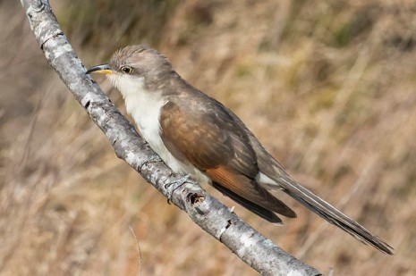
Yellow-billed Cuckoo. Photograph by Sandy Selesky.
In the woods, listen for breeding birds. In spring, the vernal pool in the middle attracts Wood Ducks along with a good chorus of wood frogs. On reaching the main trail, take a left and walk until you reach the large marsh (5). The marsh has most of the expected breeders for the habitat, although I have yet to find any Marsh Wrens or rails here. In winter, Rusty Blackbirds are occasional along here. Continue beyond the marsh, where a red maple swamp starts on the left.
The main trail eventually splits. Both forks come out within a few yards of each other. If you want to go directly to the West Meadow, head right, then turn right on the parkway and follow the directions below. Otherwise, head left and then left. Before reaching the next big intersection, you pass another marsh on the right (6). At the next intersection, turn right. You will pass the trails that led down from the water tower. The next left (7) after those follows the bottom of the hill back to Turner Field. Continuing straight leads out to the Metropolitan Parkway (8). The last few feet occasionally attract Rusty Blackbirds from fall to spring, and Connecticut Warblers have been found here as well.
The Parkway
The parkway is a busy road but can be productive. Make sure you stay on the grass or the sidewalk as cars often speed around the curves. The small marsh at the edge of the Parkway often attracts sparrows. Raptors and woodpeckers frequent the trees. If there is a good layer of snow on the ground, the heat from passing cars melts the edge, which means the roadside can be extremely productive.
Working north up the parkway, you’ll come to a field on the left. You can walk through here to the back of the McLaughlin building (9) or follow the parkway to the parking lot. Beyond the building are two small dog playgrounds, a basketball court, and a retention pond. Surprisingly, this area has attracted some of the most interesting rarities on the property, including Lark Sparrow and Gambel’s White-crowned Sparrow. This area, along with the entire parkway, can be a good spot for displaying American Woodcock in spring.
West Meadow
At the back corner beyond the basketball court, the trail exits into the neighborhood at Dawes Avenue (10). If you walk along Dawes—please do so quietly—a trail starts on the right. This leads out to the West Meadow. In spring and after heavy rain, this trail may be flooded (often to my knees), and it may ice over in winter. If it’s unpassable, you can access the West Meadow by following the parkway up toward the Avalon apartments and then down around the buildings. About halfway between the apartments and Concord Avenue, you will see a post on the side of the road (11). Cross the road to the trail, which enters the woods and loops to the West Meadow.
However you arrive, you will reach a long boardwalk across the marsh (12). Sparrows can be abundant. Willow Flycatchers breed here and Alders are occasional on migration, as are Marsh Wrens. The boardwalk is narrow and gets traffic from joggers and bikers, so be aware of your surroundings. Benches at the midpoint make a great spot to relax for a few minutes with an eye on the skies.
At the far end of the boardwalk, walnut trees and some bushes appear. They often have lingering migrants such as tanagers and grosbeaks well into October. Waxwings and Purple Finches like the area in winter. After crossing a second short boardwalk, the trail enters an area with taller trees and heads uphill. At the top, it opens to a small field with a few junipers and then reaches Walnut Street (13).
Lot 1
Carefully cross Walnut Street and then Cart Path Lane, staying right on the edge of Walnut Street until the trail bears left behind the houses. There were some nice weedy patches during construction, but they are now almost all gone. The trail goes through some pines—with regular Great Horned Owls and an occasional Barred Owl—before reaching another intersection (14). This part of the property is known as Lot 1. Taking a right leads up to the water tower, but outside of a busy spring day, there’s not a lot to see up there. Instead, head left. At the next intersection (15), you can go either way as the trail makes a circle. Starting to the left, you will soon reach a small stand of cedars. A Saw-whet Owl roosted here one winter, and it looks like a good spot for more.
Just beyond the cedars, you can go up to the left and come out at the back of Cart Path Lane. I’m told that there will be an easement even after the remaining lots have houses built. Continuing ahead and then down to the right, you will reach another intersection (16). Head right and you will pass Falzone Field. Parking for Lot 1 is here. The gate for the lot often doesn’t open early in the morning, and maybe not at all in winter, but there are six spaces outside too.
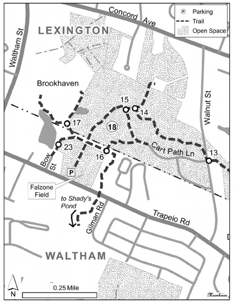
Continue straight at the intersection that leads out to Falzone, then turn right at a subtle fork and you will reach the nature trail for the Brookhaven senior housing (17). The short trail is open to the public. A few of the residents here have feeders up, which can be worth a scan. If you take the left fork instead of the Brookhaven fork, you’ll come to a spot with a view of a small pond, which is good for a few ducks and gulls and has had breeding Green Heron. The view is rather obscured compared to the view from the Brookhaven trail, but it can be a closer angle for the farther corner of the pond. The trail ends at Bow Street, which leads to Trapelo Road next to the Falzone parking lot. However, it’s just as easy and birdier to retrace your steps to reenter Lot 1.
Back on Lot 1, return to the opening for Falzone and take a left. This leads to a large field (18) with more breeding Blue-winged Warblers, displaying woodcock, and other birds. In recent years, the sumac and raspberries have grown up, which makes exploring the far corners more difficult. The trail reenters the woods and shortly will finish the circle noted above.
This walk covers the main territory of Beaver Brook North Reservation. Cross back over Walnut Street and return to the parking lot at Elsie Turner Field via the boardwalk trail, Metropolitan Parkway, and the trail at the bottom of the hill (8) and (7) to Turner Field.
Side Trails
A few side trails are worth a mention. The first two begin just after the clearing around the corner from the cemetery. These interesting trails start from the same place (19). The left trail heads to the edge of the woods just north of the middle area (4). Some wet spots there have been attractive to Winter Wrens; waterthrushes have lingered late enough in the spring to raise questions about breeding. The right trail follows similar habitat to the rest of the woods but is less used by dog walkers. It rejoins the main trail almost at the bridge to Rock Meadow (20). Loop the trail and community gardens at Rock Meadow for bluebirds, Tree Swallows, and sparrows. For more on Rock Meadow, see Bird Observer Vol. 37, No. 5: “Fall Migration Hotspots in Massachusetts: Emphasis on Sparrows,” p. 266-67 (2009).
If crossing back from Rock Meadow, staying right leads to the big marsh (5). However, well before reaching the marsh, the first trail to the right (21) is worth a short check. It follows an esker that is just below the back of the Belmont transfer station. If you’re up for a small stream crossing, take a right at the end. After crossing the stream, you can walk out through a small stand of trees to get a look from the back of the marsh that is along Concord Avenue. The trail can be overgrown from here but eventually reaches Concord Avenue.
After passing the big marsh (5), more trails lead off to the right. The second follows a gas pipeline and eventually goes through a small pine stand before dropping into the large field that is below the parkway (22).
Blue-gray Gnatcatcher. Photograph by Peter Oehlkers.
On the other side of the reservation, at the parking lot by the McLaughlin building (9), the sidewalk veers off to the north. If you cut across the grassy area here, you can pick up a trail that enters the woods and heads downhill. The trail runs next to a small stream—which can be attractive—before rejoining the main trail next to the smaller marsh (6).
For the adventurous, you can bushwhack out to the edge of the large marsh from this area. When the marsh is fairly dry, it is even possible to walk out and across it.
Behind the McLaughlin building, an old road leads through a couple fields and the back of the pine stand and out to Trapelo Road. The fields can be uneven to walk through, and you will have to cross Trapelo Road to get to a sidewalk, but it can be worth the time. The parkway is a short distance down the road, so it can be looped.
At Lot 1, three side trips are worth a brief mention. At the intersection near Falzone (16), heading east follows a trail that then bends right and leads out to Trapelo Road. Waxwings can be abundant along here. Crossing Trapelo Road, the trail enters the next segment of the Western Greenway, which is Shady’s Pond. I haven’t explored enough to know the birding potential, but it’s a beautiful walk.
Falzone Field itself can have productive edges. Sparrows and finches are abundant. Woodcocks used the field before it was turned to turf but may still be found along the fence line.
Beyond birds, the reservation is also good for a variety of other wildlife. Deer and coyote are regular, and I have seen fisher on several occasions. The fields at the top of Mackerel Hill and at Lot 1 can be productive for butterflies (50+ species) including white M hairstreak, Henry’s elfin, and pepper-and-salt skipper. Dragonflies (40 species) include the state listed mocha emerald.
One of Jason Forbes’s earliest sightings was a Great Horned Owl on the Metropolitan State Hospital grounds. Since the hospital closed and the land was turned over to the Massachusetts Department of Conservation and Recreation, he has added the reservation to his local birding loop. He wants to thank the Friends of the Western Greenway, the Waltham Land Trust, Citizens for Lexington Conservation, the New England Mountain Bike Association, and many individuals for trail work and sightings.