Steven Lamonde
Introduction
 Although Cheshire County is the second most birded county in New Hampshire according to eBird, it is often overshadowed by Rockingham County, which contains all 18 miles of coastline found in the state and all the coastal and pelagic species that come with it. However, Cheshire County's landscape of rolling hills, varied habitats, and scattered freshwater resources offer an entirely different birding vibe. And, for most of fall migration, birders can enjoy the exquisite fall foliage that adorns the region's forested hillsides.
Within Cheshire County birders regularly flock to viewpoints along the Connecticut River during both migration seasons to witness large numbers of waterfowl taking advantage of the natural travel corridor and large agricultural fields in close proximity to the river. Others prefer to hike up Pitcher Mountain or Pack Monadnock on fair-weather days for a good day of hawkwatching. Yet, the city of Keene and the surrounding central area of Cheshire County offer numerous birding locations, many of which are tucked in among tracts of urban and suburban development. As a result, these spots act as enticing stopover patches for migrating songbirds in both spring and fall.
The greater Keene area is accessible on state highways from nine directions, making it a transportation hub for southwestern New Hampshire. Routes 10 and 12 connect Keene to northern Massachusetts, Routes 9 and 12 accommodate travel to and from Vermont, Routes 10 and 12A connect with points due north, and Routes 9 and 101 connect traffic from Concord and eastern New Hampshire. Once in Keene, the state highways quickly move cars through and around the city. West Street, Main Street, Winchester Street, and many of the other main roads through downtown are packed with local shops, restaurants, and attractions.
Fall birding in Keene starts warm, with August days reaching an average high of 81.5 °F and cooling to an average high of 48.6 °F in November. Early morning temperatures can be highly variable but average 55.9 °F in August and 29.5 °F in November.
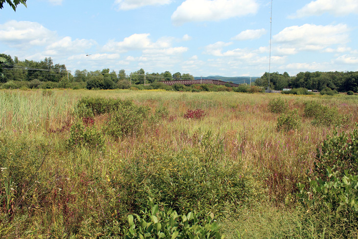
Ash Brook Wetland. All photographs by the author.
Ash Brook Wetland
Despite hosting droves of breeding Red-winged Blackbirds during the summer, Ash Brook Wetland often lacks a strong icterid presence on autumn days. Yet on certain days in October and November, flocks numbering in the hundreds will pass through the wetland. Ash Brook Wetland is best accessed from the south, after parking near the Target store at Monadnock Marketplace (42.929317, -72.300871) and walking behind the store where a paved access road begins. See Map 1: Ash Brook Wetland. The access road stretches 0.2 mile before intersecting with the Cheshire Rail Trail, which runs nearly 35 miles from the Massachusetts border to Walpole, New Hampshire.
Just behind the Target store stands a row of conifer trees that can be a great place to locate foraging Cape May, Pine, and Blackpoll warblers during fall. Past the conifers the expanse of wetlands appears. Although little open water is visible from the access road, there are a few vantage points to check for ducks, geese, and grebes. Listen here for Swamp Sparrows singing late in the season, and look closely through the reeds for Marsh Wrens. Both species also occur in the wet drainage ditch west of the access road before the grassy field starts. Depending on the time of day, one of the best spots for photographing warblers is along the forest edge west of the access road at its southern terminus. A total of 21 warbler species have been observed at Ash Brook Wetland and, on some mornings in the fall, the branches seem to drip color as large, mixed-species foraging flocks of warblers and vireos move through the trees.
The grassy shoulders alongside the access road yield high numbers of sparrows during the fall, and some days can offer seven species in a single walkthrough. Lincoln's, White-crowned, and Field sparrows are good highlights here, and large flocks of Song and Savannah sparrows are noteworthy in their own right. Upon reaching the Cheshire Rail Trail (frequently referred to as the "bike path"), one has the option of traveling east, west, or continuing north to Pitcher Street. Dog-walkers and birders alike often park where Pitcher Street meets the rail trail (42.931576, -72.302302), but there is no designated parking area. Heading west veers away from Ash Brook Wetland but offers thicker patches of forest, several backyard bird feeders, and a corridor of shrubby vegetation under the power line that runs parallel to the bike path. Heading east, on the other hand, offers additional wetland views and thick hedgerows. Northern Mockingbirds, Gray Catbirds, and Brown Thrashers enjoy the dense foliage and are most frequently observed foraging along the edges of the rail trail, perched in the trees, or surveying the wetland from the telephone wires. On the north side of the bike path, east of the access road, the wetter areas are worth checking for Northern Waterthrush, Common Yellowthroat, and Palm Warbler.
Red-tailed Hawks enjoy scanning for prey from perches up and down the radio tower on the eastern side of Ash Brook Wetland. Although the wetland lacks the expansive views of many hawkwatch sites, the skies above the wetland and nearby field are devoid of trees, offering decent views of migrating raptors. Looking southwest over the wetland toward the Horatio Colony Preserve ridgeline can yield lone accipiters and buteos, Turkey Vultures, and small kettles of Broad-winged Hawks.
If time allows, or walking around the wetland turns up few birds, a quick stop by Antioch University New England can be fruitful.
Map 1. Ash Brook Wetland.
Antioch University New England
Starting north of Ash Brook Wetland, head east along the Cheshire Rail Trail. Continue walking along the bike path, crossing the pedestrian bridge over Route 9, until you reach the University 0.4 mile from the junction with Pitcher Street. Alternatively, you could park at the University (42.931820, -72.294804), but this space is generally reserved for students, faculty, and staff. More parking is available in the Kohl's Plaza (42.932366, -72.295681), where a cut-through between the Famous Footwear and Great Clips businesses provides quick access to the rail trail.
Bird feeders are located all along the eastern side of the university building, with two main feeder stations positioned in front of the main entrance and library windows. This second feeder station is the largest and is a mere 20 yards from the rail trail. The feeders, maintained by the Antioch Bird Club, are nearly always active, and the wooded patches to the north and south of the bike path provide ample foraging opportunities for a diversity of songbirds. As with most feeders, the occasional Cooper's and Sharp-shinned hawks swoop by, and both species are most often seen perched in the trees above the feeders or along the rail trail. Across from the University, to the south of the rail trail, a dirt patch is indirectly maintained by the city of Keene, which uses the site for dumping excess snow during winter months. As a result, mixed-species sparrow flocks forage here throughout the fall. Highlights include Lincoln's Sparrow, White-crowned Sparrow, and a pair of Dickcissels found in early October of 2017. Following rain showers, the dirt patch usually pools with water, which can attract songbirds and the odd shorebird.
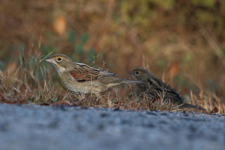
Dickcissel pair found October 2017.
Tucked into the trees on the north side of the bike path, two brush piles are hidden. The larger one is positioned near the open lawn on the west side of the university building, and the smaller pile is about 30 meters east of the bird feeders. Sparrows and the resident Carolina Wren frequently visit both locations. On the south side of the bike path, the powerline corridor is dominated by sumac trees and young aspen, which host early-successional forest obligates such as Prairie Warbler, Eastern Towhee, Brown Thrasher, and Indigo Bunting.
Ashuelot River Park
Parking is available in the Elm City Bagels plaza (42.932905, -72.287792) at the junction of Island Street and West Street. See Map 2: Ashuelot River Park. From the parking lot the main trail loops through a small open area before heading due north. Although the open green can be busy with people enjoying yard games in the afternoons and evenings, mornings are relatively quiet and devoid of human activity. West and a bit north of the green a dam-restricted impoundment of water often hosts waterfowl, including Mallards and American Black Ducks. Great Blue Herons frequently visit the down-river side of the dam to forage. A suspension bridge crossing the river (just north of the green) provides excellent viewing of the river upstream and downstream of the dam. This location is also a great place to watch flocks of Cedar Waxwings pick insects out of the air above the water's surface.
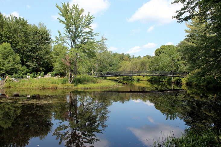
Ashuelot River Park.
From the bridge, two options of travel present themselves: following a trail up the western side of the Ashuelot River, or following the Jonathan Daniels Trail (JDT) along the eastern side. Taking the western option offers a good mix of habitats, ranging from floodplain forest and open wetland, to shrubby habitat under the power line corridor. One of my best encounters on this trail, a Rusty Blackbird, was found in the shrubs along the river bank not 200 feet from the bridge. Checking this area and similar microhabitats on either side of the river can also turn up Northern Waterthrush. Listen and watch for Belted Kingfishers and swallows as they forage along the waterway.
Taking the JDT offers more mixed deciduous-coniferous forests than the western trail and passes two oxbow ponds and forested wetlands. Additionally, an abandoned lot with patches of vegetation lies off the east side of the JDT about 200 feet north of the suspension bridge. I have yet to find any out-of-the-ordinary species here, but barring any redevelopment plans, I imagine the lot will turn into a sparrow haven over the next few years as nonwoody plants continue to proliferate. Continuing northward, the JDT meanders around the back of an apartment complex and passes the first, and largest, oxbow pond on the left. Not much farther along the trail, a second oxbow pond appears on the right, partially hidden by dense vegetation. Despite the dense canopy cover and thinness of the water feature, Wood Ducks are still attracted to these ponds throughout the fall.
Roughly 0.8 mile from the suspension bridge, the JDT forms a T-intersection with the Appel Way Trail. Moving west on the trail takes pedestrians underneath Route 9 to Wheelock Park (0.7 mile), which is a suitable place to watch for migrating Common Nighthawks in late August and early September. Heading east from the T-intersection, the trail ends at Court Street after an easy 0.2-mile jaunt along the forested pathway.
Perhaps one of the understated features of the JDT, at least from a birding perspective, is the relative quietness of the pathway underfoot. Despite being covered by forest canopy almost its entire length, falling leaves are constantly crushed by foot traffic. The popularity of the trail, especially for cycling commuters and joggers, helps maintain the quiet footing, which increases one's chances of hearing distant birds and decreases the likelihood of flushing birds out of sight.
For birders in need of a quick breakfast or energy boost, Elm City Bagels and the local Starbucks café are located on West Street adjacent to Ashuelot River Park.
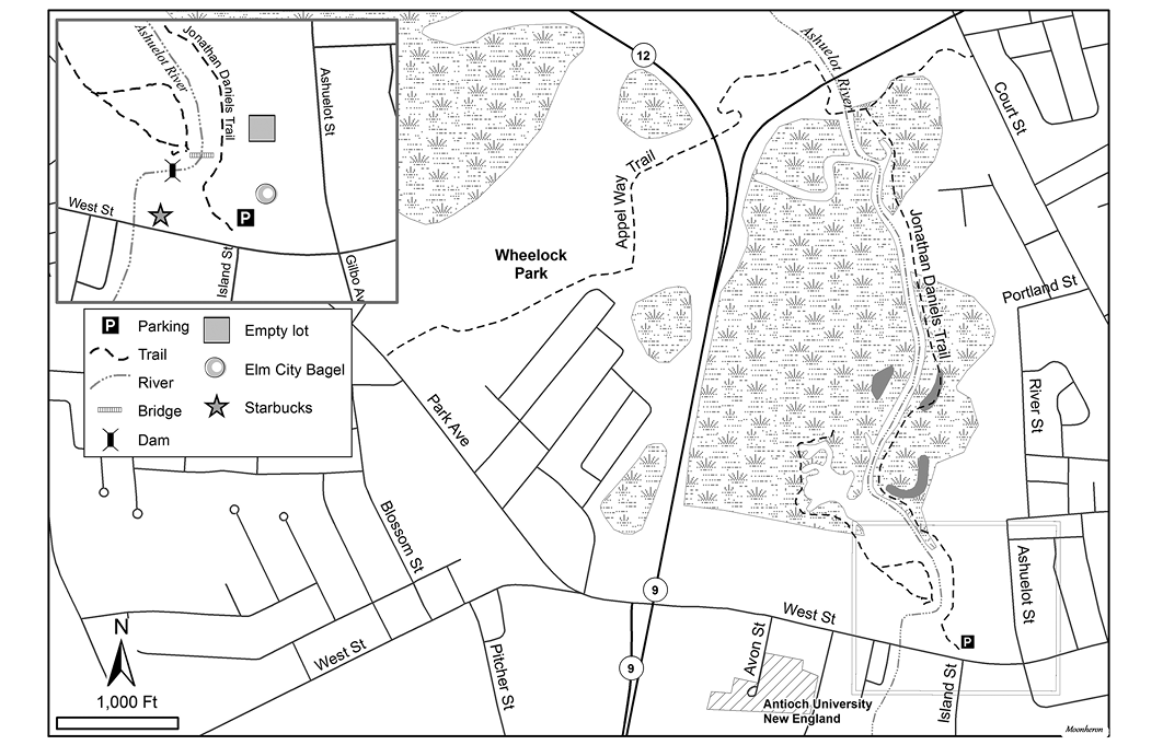
Map 2. Ashuelot River Park.
Krif Road
Relative to other birding hotspots in and around Keene, Krif Road boasts the greatest amount of agricultural acreage. Additionally, most of the field edges have drainage ditches that supply a substantial amount of dense grasses and shrubs, much to the delight of sparrows. Clay-colored and Vesper sparrows have been found here in small numbers. Tennessee and Connecticut warblers have also been reported from the forested and shrubby edges around the field. Visiting Krif Road in the evening in early fall, you can witness flights of migrating Common Nighthawks or have a rare look at a Short-eared Owl. See Map 3: Krif Road, Dillant-Hopkins Airport, and environs.
At the corner of Comwell Drive and Krif Road, the southern end of the field often becomes flooded after rainstorms. This large, shallow pool often attracts migrating waterfowl, including teal, American Black Ducks, and Snow Geese. Mixed flocks can number in the hundreds. Shorebirds are an uncommon sight during migration in Keene, but Krif Road is one of the best places to look.
Birding Krif Road and Comwell Drive can be done by car, which is convenient during snaps of cold weather. Wide shoulders along the road allow for ample parking, but the best place to park is at the east end of Krif Road in the pulloff on the north side of the road (42.914714, -72.285658), at the gate to Keene State College's Owl Athletic Complex. Generally, Krif Road and Comwell Drive do not see much vehicular traffic, and pulling off to the side anywhere for a brief amount of time is not frowned upon. There is a UPS facility at the north end of Comwell Drive, so take care to leave plenty of room for large trucks to pass by.
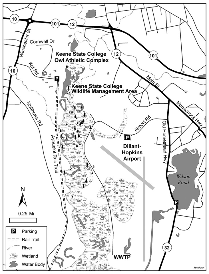
Map 3. Krif Road, Dillant-Hopkins Airport, and environs.
Dillant-Hopkins Airport and Airport Road
Of all the local birding places around Keene, Dillant-Hopkins Airport and Airport Road along its perimeter boast perhaps the greatest diversity of habitat. Unique to the airport is the extensive grassland surrounding the airport's two runways. Mature deciduous and pine forests, forested wetland, freshwater marsh, and shrubland surround the airport in a complex, bird-rich mosaic.
Airport Road.
To get to the airport from Keene, travel east on NH-101. Take a right onto main Street/NH-12 South, and travel 0.9 mile before turning right onto Old Homestead Highway/NH-32 South. Two-tenths of a mile after turning onto Old Homestead Highway, turn right onto Airport Road.
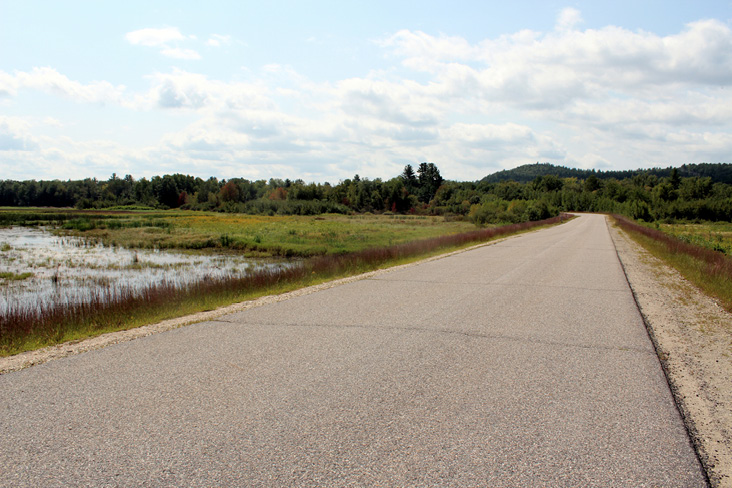
Driving down Airport road, the view opens to the right at 0.1 mile. This area is worth checking for American Kestrel and Vesper Sparrow perched on the fence line. Thirteen other sparrow species have been observed at the airport, most notably Grasshopper Sparrow, which is best found at airports across New England. In late fall, this open patch of land hosts American Pipit, Snow Bunting, and Horned Lark. At 0.5 mile, just after the airport parking lot, there is a gate. The gate blocks vehicular traffic to the Keene Waste Water Treatment facility on weekends, but it is open Monday-Friday from 6:30 am to 3:00 pm. Even if the gate is locked, public foot-traffic is welcome at any time. Free parking is available outside the airport building (42.906949, -72.272560), and the lot here is never full. When the gate is open, birders can drive in and park anywhere along the side of the road. Be courteous to drivers going to and from the plant, and pull off far enough to leave room for them to pass. Thankfully, the road is rarely busy.
Starting at the gate, Airport Road bisects a thin strip of wetland. Here you can see bitterns and herons in addition to the more standard Marsh Wren, Swamp Sparrow, and Red-winged Blackbird. After the wetland the road passes through a mixed deciduous-pine forest where all six common woodpecker species can be found until most Yellow-bellied Sapsuckers and Northern Flickers depart in late October.
After moving through the forest, the road curves to the southwest 0.3 mile after the gate. On the right, a short dirt road leads toward agriculture fields along the Ashuelot River. The forest at the end of the dirt road is the Keene State College Wildlife Management Area and is open to the public year-round. The start of the dirt road is a good place to park and has enough room for cars to pull completely off Airport Road. Just after the junction with the dirt road, Airport Road cuts through a large, open tract of wetland. The wetland itself hosts a variety of microhabitats, from dense stands of cattails to semi-dry clusters of shrubs. Ground crews at Dillant-Hopkins airport cut back the vegetation here every few years, which maintains a low-cut wet field with bushy patches. The shrubs here often attract a Northern Shrike during the winter months, but they can be seen as early as late fall. This general area can present large mixed- and single-species blackbird flocks. Rusty Blackbirds are most frequent here in September and October.
The road begins to turn southeast 0.5 mile from the gate, and early-successional forest rises up on either side of the road. This corner of Airport Road is spectacular for photographing mixed-species foraging flocks of warblers in first light. After the turn, mature forested wetlands dominate both sides of the road. Relative to other areas near Keene, Pileated Woodpeckers can be observed here semi-regularly. Wood Ducks, with their adept maneuvering skills, can often been seen slowly swimming through the wetlands on either side of the road. Starting 0.9 mile after the gate, the forest on the east side of the road thins out, and views of the open airport lands are regained. The large wetland on the east side of Airport Road, beginning 1.1 miles after the gate, is another place to check for flocks of waterfowl. You can observe shorebirds, ranging from Spotted Sandpiper to Greater Yellowlegs, here and at the first wetland if the water is shallow enough. Approximately 1.5 miles after the gate, the road ends at the gate to the Keene Waste Water Treatment Plant. There is no convenient place to turn around, since the road past the facility's gate is off limits, but there is enough room for most cars to perform a three-point turn.
Similar to Krif Road, the wetlands often flood, providing a large expanse of shallow water for waterfowl to rest and forage. Common Merganser, Hooded Merganser, Green-winged and Blue-winged teal, and Wood Duck, among other waterfowl, typically stop over during the fall. Alas, many waterfowl at this location seem to be one-day wonders. Other notable fall migration sightings at the airport include large numbers of Great Egret, Northern Harrier, Sora, Upland Sandpiper, Yellow-bellied and Olive-sided flycatchers, Philadelphia Vireo, and Blackpoll Warbler.
Wilson Pond
Wilson Pond stands out as one of the most accessible bodies of standing water in the Keene area. Just a short drive from downtown Keene, Wilson Pond is a 72-acre pond with an average depth of seven feet. Just 0.8 mile south on Old Homestead Highway/NH-32 from the airport entrance, Wilson Pond is an easy addition to birding trips to the airport. Common species at Wilson Pond in the fall include Hooded and Common mergansers, Ring-necked Duck, Common Loon, and various dabbling ducks and geese. More notable observations include White-winged and Black scoters, Bufflehead, Ruddy Duck, Red-throated Loon, and Double-crested Cormorant. Each of these species regularly occurs along the New Hampshire coast, but they are a treat for Cheshire County birders. A small dirt pulloff serves as a parking space (42.898245, -72.263581) and provides access to a public boat ramp.
Steven Lamonde is an avid birder and recent graduate of Antioch University New England, where he obtained his MS in Conservation Biology. While at Antioch, Steven served as a Golden-winged Warbler graduate research assistant to Audubon Vermont., He also co-directed the Antioch Bird Club, which organizes regional birding trips and offers educational walks and talks for community members. Steven has traveled extensively throughout New England in search of birds, particularly wood warblers and raptors.