Nate Marchessault
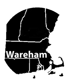 The Wareham area is not well known as a birding hotspot. In fact, most people probably have been to Wareham only to get to Cape Cod or to watch cranberries being harvested. Despite the lack of birding coverage, there are plenty of locations that warrant exploration all year.
Due to its coastal location, Wareham's beginnings were in the shipbuilding industry. Today, cranberries are its major industry. Therefore it is only natural that one of the birding locations in the area is a complex of old cranberry bogs. Wareham, Bourne, and Sandwich are the towns that abut the Cape Cod Canal. The canal slices through Bourne and Sandwich—which are officially part of Cape Cod and Barnstable County—putting a small section of each town on the mainland. Wareham, west of Bourne, is entirely on the mainland and is part of Plymouth County. It was incorporated as a town in 1739 by combining territory from parts of Rochester and Plymouth.
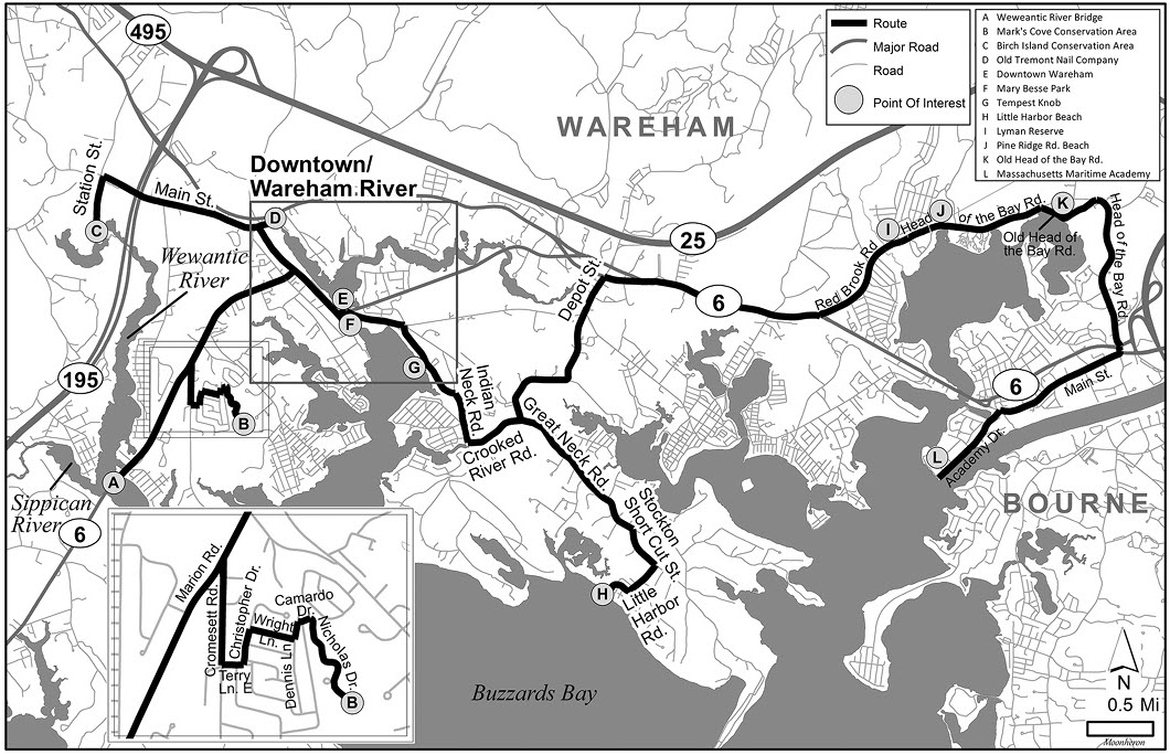
The Cape Cod Canal is an artificial waterway that was built to improve navigational safety. "The Canal" (as locals call it) is an approximately seven-mile-long shortcut from Buzzards Bay to Cape Cod Bay that allows ships to bypass more than 100 miles of treacherous Atlantic Ocean waters along the coastline of Cape Cod. The Boston, Cape Cod, and New York Canal Company began digging the canal and building the bridges over it in 1909, finishing in July 1914. The canal was a privately owned toll waterway until the federal government purchased it in 1927. The United States Army Corps of Engineers widened the canal to 480 feet from the original 100 feet and built the current Bourne and Sagamore bridges and a new railroad bridge in 1935. The canal had a different entrance when it was first built; remnants of the original entrance near Mashnee Island in Bourne can be seen on a satellite map.
Map 1. Overview of Wareham.
Weweantic River
Begin the Wareham area birding route at the Weweantic River bridge (A), which is accessible from a pulloff on Route 6. (See Map 1. Overview.) Named by the Mashpee Wampanoag Tribe, the Weweantic and its short tributary, the Sippican River, were once important runs for diadromous fish but have been blocked by dams. Recently, the Buzzards Bay Coalition has developed plans to dismantle some of the dams in order to restore the flow between salt and fresh water and recreate the productive spawning routes as well as enhance the overall health of the waterway.
The bridge is a good spot to check for Barrow's Goldeneye in winter, with multiple individuals having been seen in recent years. They accompany the regular assortment of waterfowl: Buffleheads, Hooded Mergansers, and Common Goldeneyes. The flow of water under the bridge keeps this part of the river from icing over during the most frigid weather, so check the area even when other nearby waterways are frozen because occasionally you may find large concentrations of birds.
Cape Cod Canal Railroad Bridge and Bourne Bridge from Massachusetts Maritime Academy. All photographs by the author.
In the warmer months, birding by kayak or canoe is the way to go. Tides generally are not a concern this far up in Buzzards Bay, so timing the tide is not necessary. There is a small trail from the pulloff on Route 6 that you can use to launch a boat, or you can use the boat launch down River Road just south of the bridge. Once on the water, you can follow the main channel of the Weweantic River until the dam at Horseshoe Mill or take the small tributary on the left, the Sippican River. Both are worth exploring. While paddling along the river, listen for songbirds singing in the forest and Marsh Wrens, locally uncommon in Buzzards Bay, in the cattails and phragmites. In early spring and fall, the phragmites and cattails are also productive spots for rails and other migrating marsh birds.
You can find diamondback terrapins by paddling into the small marsh between the marina and the parking area off of Interstate 195 (I-195). The diamondback terrapin is the only North American turtle that is endemic to estuarine areas; it is classified as vulnerable federally and threatened in Massachusetts.
In the fall, lots of baitfish get pushed up into the river, followed by hungry striped bass. It is not unusual to see a few stripers hitting topwater, so for the birder who enjoys a bit of fishing, a rod and reel are worth bringing along for a double-whammy of outdoor fun. Flocks of terns, Double-crested Cormorants, and Greater Yellowlegs accompany the bass upstream.
From the parking area on Route 6, travel north for one mile, then turn right on Cromesett Road. In 0.33 mile turn left onto Terry Lane East. Take the first left onto Christopher Drive, then turn right in 600 feet onto Wright Lane. At the end of Wright Lane, turn left onto Dennis Lane. Take the first right onto Camardo Drive. In 200 feet, Camardo Drive curves right and becomes Nicholas Drive. Follow this for 0.3 mile to the gate and parking area for Mark's Cove Conservation Area (B).
Mark's Cove Conservation Area
A fine example of how cooperation among conservation organizations can result in large-scale land acquisition, this 118-acre area with two-and-one-half miles of trails is a conglomeration of parcels owned by Buzzards Bay Coalition, Wareham Land Trust, Wildlands Trust, Mass Audubon, and the Town of Wareham. A copy of the trail map can be found here: www.savebuzzardsbay.org/wp-content/uploads/2016/02/map_marks-cove-conservation-area.pdf
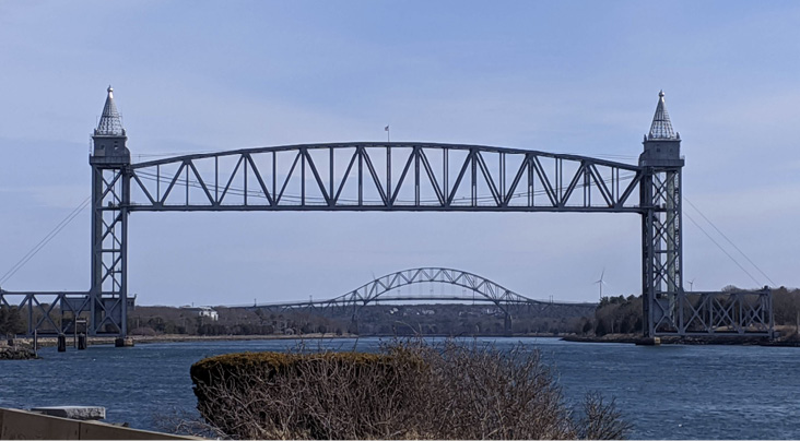
Overgrown bogs at Mark's Cove Conservation Area.
The small ponds on either side of the entrance attract Mallards and, occasionally, American Black Ducks or American Wigeons. Beyond the ponds in fall, winter, and spring, the old cranberry bogs—densely overgrown with pines, oaks, and small shrubs—can be teeming with songbirds such as Golden- and Ruby-crowned kinglets and the occasional warbler. The small outflow at the southeastern edge of the bogs is particularly good for semi-hardy lingerers such as Eastern Towhees, Hermit Thrushes, and Gray Catbirds, which are accompanied by the comparatively more common juncos and White-throated Sparrows. In irruption years, the trails into the woods along the bogs can be good for crossbills. The area isn't notably diverse in terms of bird life in the summer, but walking into the forest is almost guaranteed to yield a backdrop of chattering Brown Creepers, Red-breasted Nuthatches, and Pine Warblers, always easy on the ears.
Reverse your route and return to Route 6. Travel north on Route 6 for 0.7 mile, then turn left onto Gibbs Avenue. Turn left onto Main Street, and in 0.9 mile turn left onto Station Street. Follow this to the end to reach Birch Island Conservation Area (C).
Birch Island Conservation Area
The island at Birch Island Conservation Area isn't an island, and there aren't any birches around either. The "island" is a spit of upland forest along an oxbow of the Weweantic River and is owned by the town of Wareham. The Birch Island Conservation Area abuts the Weweantic River Reserve, owned by the Buzzards Bay Coalition. Trails connect the two conservation areas, and from Birch Island you can walk to Horseshoe Mill, an interesting and historic part of the Weweantic River Reserve that provides access to fresh and brackish sections of the river. In addition, Birch Island and Horseshoe Mill offer a diverse array of habitats with mixed conifer and hardwood forests, maple swamp, salt and freshwater marshes, a small weedy field, and a small patch of white cedar swamp.
A copy of the trail map for Birch Island Conservation Area can be found here: https://www.savebuzzardsbay.org/wp-content/uploads/2016/06/map_birch-island-conservation-area_horseshoe-mill.pdf
These diverse habitats attract a wide variety of birds, making birding productive here year-round. In spring, this trail system is one of the more productive stopovers for migrants in the Wareham area. The short trail in the center of the Birch Island parking lot leading up a hill seems to be the most reliable place for migrants, but keep an eye out for mixed flocks throughout your walk. Follow the loop trail westward along Birch Island, which pretty much parallels the Weweantic River. In summer, this area hosts an assortment of breeding birds. Wood Ducks and Swamp Sparrows frequent the freshwater marsh along the river, and Great Horned Owls nest in the upland forest. Be sure to peek through the trees to look at the river every now and again. Depending on how much the river has receded over the summer, shorebirds or waders such as the occasional Little Blue Heron can be found. In winter, the Weweantic River rarely freezes over completely, making it another worthwhile stop for waterfowl when all the ponds start to freeze. When the trail comes to a T, continue right to reach the weedy field. In fall, this area can be interesting for sparrows. Continuing past the field takes you over the old Horseshoe Mill. Stop here and check the river for ducks and waders. This is also a good spot in the breeding season to look for Baltimore Oriole and Blue-gray Gnatcatcher nests. Belted Kingfishers often can be heard rattling in the brackish marsh to the north. From here you can continue to explore some of the trails into the forest or follow the main trail covered in old slag back to the parking lot.
From Station Street, return to Main Street and take a right. Follow Main Street as it curves slightly to the right, then turn left and make an immediate quick right onto Elm Street. In 500 feet, turn right into the old Tremont Nail Company parking lot (D), and head to the southeast corner to reach your first stop at the Wareham River.
Wareham River
The Wareham River once was a reliable location for Canvasbacks in winter; unfortunately—as in many of the old "Can" ponds—their numbers have dwindled to zero. Nonetheless, this is a fantastic area for observing waterfowl, gulls, and terns from fall through spring. Interestingly, concentrations of each species are faithful to certain locations of the river.
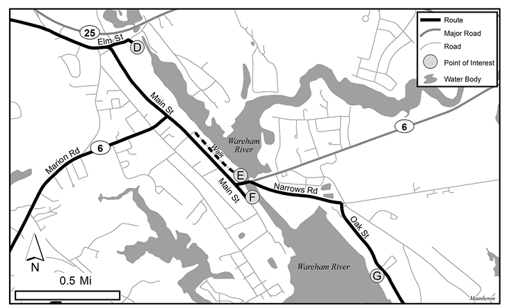
Map 2. Downtown/Wareham River.
The first stop along the Wareham River is where Parker Mills Pond feeds into it. (See Map 2. Downtown/Wareham River.) You can access the water from the parking lot of the old Tremont Nail Company. Waterfowl are typically limited to a group of Mallards—the only reliable spot for them on the river—and a Mute Swan or two, but there are feeders on the opposite side of the river, and the area is lively with songbird activity.
Take a left onto Elm Street, then turn left onto Main Street, which goes straight through downtown Wareham. There are several spots to turn into the downtown parking area, but keep driving through town and turn left into the lot just before the bridge. Park in one of the first spots on the right (E), where you will usually see Common Goldeneyes up close, Hooded Mergansers in the small cove to the east, and groups of Gadwalls and geese in the distance. Depending on the tide, gulls may be out on the mud flat straight ahead or the peninsula that juts out to the left. Be sure to look them over carefully because Iceland and Lesser Black-backed gulls may be in the mix. Keep an eye out for Bald Eagles if all the gulls flush at once, as they are relatively common here and are likely nesting in the area. If you have the time, walk 0.3 mile along the parking area to the train station; there are usually a group or two of American Wigeons and numbers of Mute Swans in the river here.
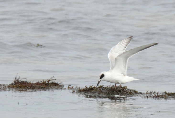
Forster's Tern.
Return to your car, take a right out of the parking lot, then turn left onto Main Street. Mary Besse Park (F) is approximately 250 feet on the left. You can walk along the river to the bridge, where there are usually several Hooded Mergansers swimming underneath and Red-breasted Mergansers a bit farther out. The birds here will be in close, offering good views. The view of the river at the bridge is practically due north and makes for great lighting conditions for observing the beautiful iridescence of a Bufflehead, goldeneye, or scaup. On several occasions, I have observed a Cooper's Hawk hanging out under the bridge.
Go north on Main Street, turn right onto Route 6, and go over the bridge. Take an immediate slight right at a set of lights onto Narrows Road. In 0.5 mile, take the first right onto Oak Street to a small parking area at a boat launch called Tempest Knob (G). There can be several hundred Buffleheads associating with Greater Scaup here, and Brant frequent this stretch as well. In the fall, large numbers of baitfish attract terns; you can see Common, Roseate, Forster's, and Black terns fishing or loafing on the boats moored in the area.
Drive east on Oak Street for 0.3 mile, and turn right onto Indian Neck Road. In 0.4 mile turn left onto Crooked River Road (which will become Great Neck Road as you continue straight). In 1.75 miles, turn right onto Stockton Short Cut Street. In 0.3 mile, turn right onto Little Harbor Road and follow it until you reach Little Harbor Beach (H). (See Map 1. Overview.)
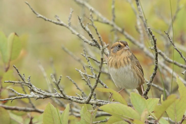
Nelson's Sparrow.
Little Harbor Beach
Truly a hidden gem, Little Harbor Beach lies tucked away in the sleepy area of Great Neck in Wareham. The beach limits parking to residents only, so visit in the off-season—when the birding is best. A trail at the end of the parking lot goes through the marsh to the inlet, and from there you can walk the beach back to the parking lot. This area is a magnet for random notable species, and you really never know what you will find. Long-billed Dowitchers, American Bitterns, Pacific Loons, Barrow's Goldeneyes, Black Skimmers, Parasitic Jaegers, and even shearwaters (scarce this far up in Buzzards Bay) have shown up here.
More reliably, the tall Spartina grass along the marsh trail is a magnet for Sharp-tailed Sparrows from late September through October, with Nelson's Sparrows being regular. In the early spring, there are usually American Oystercatchers hanging out in the marsh and a Piping Plover or two on the beach. On a day with favorable winds, you can observe a diversity of migrating hawks. In winter, harriers soar above the marsh. You can see the occasional Ipswich Sparrow in the dunes and Horned Larks and Snow Buntings around the edges of the parking lot. Ruddy Turnstones will sometimes mix with Sanderlings and Dunlins along the beach. High tide is best for viewing the decent numbers of waterfowl in the bay because the water is shallow, and on a low tide birds become mere specks on the horizon. Occasionally, large groups of Horned Grebes can be seen in the water along Stony Point Dike to the east, which is a manmade peninsula constructed from the dredgings from the Cape Cod Canal.
From Little Harbor Road, turn left onto Stockton Short Cut Street. Turn left onto Great Neck Road. Follow Great Neck Road for approximately 1.2 miles, bear right at the fork to remain on Great Neck Road, and continue straight for 1.5 miles (Great Neck turns into Depot Road when you cross the railroad tracks). Turn right onto Route 6, follow it for 1.7 miles, then turn left onto Red Brook Road. In 0.8 mile, you will arrive at the Lyman Reserve (I); there is a parking lot on the left side of the road.
Lyman Reserve and Buttermilk Bay
Buttermilk Bay is the northernmost saltwater body in Buzzards Bay. It is thought that Buttermilk Bay had been a kettle pond that was breached by Buzzards Bay. Red Brook is critical to the migration and spawning of sea-run brook trout. Owned by the Trustees of Reservations, Lyman Reserve features a 1.5-mile loop trail that goes through upland woodlands, pine barrens, and marshland, parallels the stream, and leads to Buttermilk Bay. Another 0.25-mile trail loops along the sandy beach.
A copy of the trail map can be found here: http://www.thetrustees.org/assets/documents/places-to-visit/trailmaps/Lyman-Trail-Map.pdf
Cross the road and walk the short trail to the overlook and beach for a good view of Buttermilk Bay, which is rich with baitfish. Waders such as Great Blue Herons and Great Egrets hunt along the shoreline. In late July through fall, be sure to scan the marsh at the outflow of Red Brook, which is a favored location of Yellow-crowned Night-Herons. In winter, diving ducks collect fish and shellfish, and dabbling ducks feast on vegetation along the edges of the bay. When you return to the parking lot, take the trail along Red Brook, which features some nice (albeit small) segments of cattail marsh. As you walk, listen for Belted Kingfishers, Marsh Wrens, and Swamp Sparrows, and take a minute to appreciate the crystal-clear waters of the stream. After the first bridge, the trail up the hill on the left leads to a managed pine barrens stand. Here, you may encounter Prairie Warblers, Field Sparrows, goldfinches, and towhees in season; it is a good spot to check for finches in irruptive winters. Follow the trail through the sparse pitch pines to get down toward the river; follow it toward the road and back over the bridge to return to the parking area.
When you leave Lyman Reserve, turn left (east) on Red Brook Road, which in approximately 0.1 mile becomes Head of the Bay Road. In 0.4 mile, you will reach the large dirt parking area for Pine Ridge Road Beach (J). Park here and scan Buttermilk Bay. This is a good alternative to walking the trail to the water at Lyman Reserve in inclement weather, and the marshes in this little cove can be another haunt of Yellow-crowned Night-Herons in late summer.
Continue east on Head of the Bay Road for 1.3 miles, and take a sharp right onto Old Head of the Bay Road to access Little Buttermilk Bay. There are a few pulloffs on the right side of the road (K) that provide views of the bay that are not visible from the other two vantage points. Because the water is shallow near the shore, it can be productive for dabbling ducks and geese, but it is deep enough farther out for diving ducks and loons, too.
Follow Old Head of the Bay Road east until it reconnects with Head of the Bay Road, and turn right. Follow Head of the Bay Road for approximately 1.3 miles, and at the traffic circle, take the second right onto Main Street. In 1.0 mile, turn left at the first set of lights onto Academy Drive, and travel 0.7 mile to the Massachusetts Maritime Academy (Mass Maritime) (L).
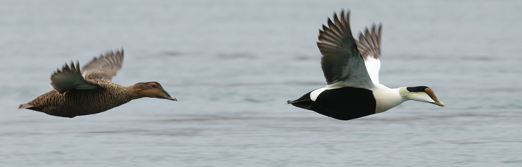
Common Eiders.
Mass Maritime
Mass Maritime Academy sits at the western terminus of the Cape Cod Canal. On the coldest days of winter, this is a great spot to bird by car. The campus here is generally quiet, and parking is available past the gate and along the canal year-round. Park here and walk along the sidewalk beyond the cul-de-sac at the end of the parking lot to reach a small beach.
In the warmer months, American Oystercatchers hunt for shellfish in the shallow waters along the beach, and terns often chase baitfish that are sucked in and out of the canal. The prime season here, though, is when things begin to cool off in late fall through early spring. The mouth of the canal and surrounding waters are a great spot to find a good diversity of waterfowl. The sheer number of Common Eiders— hundreds, if not thousands—paddling in this part of the canal in winter is a fantastic sight. You can see—or photograph—eiders in many plumages and observe a variety of behaviors at close range. Scan carefully for a King Eider in the mix. Around sunset you can watch as, group by group, eiders fly out of the canal to roost at sea for the night, a fantastic sight to end a day of birding.
Food, Facilities, and Other Birding Resources
Though there is a bit of a tourist presence in Wareham area, there is also a stable year-round population, so most shops and restaurants stay open throughout the year. The Target Plaza off I-195 in Wareham has a few places to eat, and there are bathrooms and a Starbucks inside Target. There are also several dining options in downtown Wareham. The Narrows is a nice spot for lunch and overlooks the Wareham River. Onset also has several places to eat and is a quaint little village. To bird other conservation areas not mentioned in this article, check out Wareham Land Trust at http://warehamlandtrust.org/properties/ and Buzzards Bay Coalition's website, which has a fantastic compilation of conservation areas in the Buzzards Bay area at https://www.savebuzzardsbay.org/places-to-go/
Nate Marchessault is an avid birder and wannabe naturalist from Falmouth, Massachusetts. When he's not soliciting people for Where to Go Birding articles for Bird Observer he usually can be found leisurely strolling outdoors enjoying the flora and fauna of Cape Cod and the surrounding area. He is president of South Shore Bird Club and enjoys co-leading walks with other conservation organizations to educate and inspire those interested in birds and nature.