Thomas Berriman
(also see: Birding Essex County, Vermont, part 1)
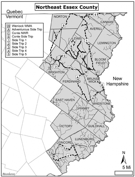
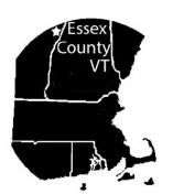 The northern section of Essex County, Vermont, includes two of the best boreal and warbler birding locations in the state: Moose Bog in the Wenlock Wildlife Management Area (WMA) and the Silvio O. Conte National Wildlife Refuge’s Nulhegan Basin Division. While there is plenty of wilderness to explore throughout the area, you will have good access for driving to the heart of these two places. You can access this northern section by a paved road along its perimeter. See the map of Northeast Essex County for an overview. Route 114 from the Village of Island Pond connects with Route 102 in the northeastern corner of the state and then returns to Island Pond westerly by Route 105. During the fall months, the ponds that abut Route 114 along the Canadian border provide resting stops for most species of migrating waterfowl.
Wenlock Wildlife Management Area
Moose Bog
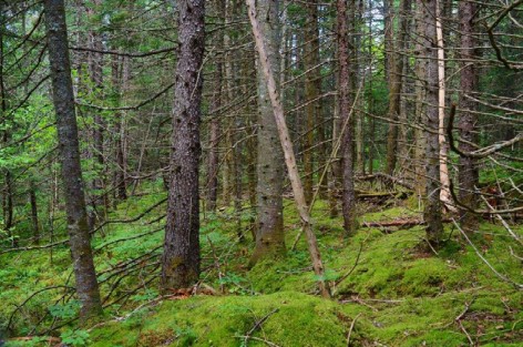
The Moose Bog Trail in Wenlock WMA is the crown jewel of birding in the Northeast Kingdom. In a short mile and a half walk you can find four boreal species on a regular basis year-round. Black-backed Woodpecker, Gray Jay, Boreal Chickadee, and Spruce Grouse breed near the trail.
From the stop intersection with the blinking red light in Island Pond (point of interest #1 on the Wenlock WMA map), drive east on Route 105. At 8.3 miles, there is a large pull-off on the left about 0.5 mile after you cross railroad tracks. During the winter months this may be the only available place to park if snow depths exceed one foot. It is also not a bad place to stop and bird year-round. Gray Jays frequent this location as well as Black-backed Woodpeckers. Kinglets and nuthatches are plentiful.
From late spring through fall, there are two other places to park closer to the trail. At 8.7 miles—or 0.3 mile from this pull-off—on the right shoulder is one end of the trailhead. There is usually enough room for two or three cars to pull off the roadway here. The preferred place to park is on South America Pond Road, which is 9.3 miles from Island Pond and one mile east of the pull-off. The red gate is open most of the year except during mud season from April to mid-May. Even in winter the gates are open, and with 4-wheel drive you can navigate the 300 yards to an opening wide enough for six cars on the right side of road.
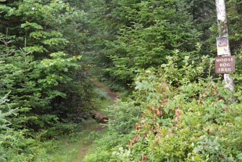
Moose Bog trailhead. All photographs by the author.
On some visits you may not have to leave this parking area to find two or three boreal species. Spend at least 15–25 minutes here listening to what is around before starting the trail. During crossbill years there are frequent fly-overs here. The Moose Bog trailhead is another 200 yards farther along South America Pond Road on the right. There is a sign warning hunters about the difference between Ruffed and Spruce grouse, but no sign to indicate you are at the trailhead. The trail winds through a mix of balsam fir, black spruce, and northern white cedar. From late March through May, listen for the flutter flight of male Spruce Grouse as they fly from leks to branches 10 feet off the ground. The birds are almost tame this time of year and spend large amounts of time on territory displaying for females, who are often close by. Often these grouse may be perched at eye level or foraging along the trail. At any point along this trail, you can find any of the four boreal species. Year-round, you are likely to find Golden-crowned Kinglets, Red-breasted Nuthatches, Blue Jays, Brown Creepers, Ravens, and Hairy, Downy, and Pileated woodpeckers. In spring through summer, expect to find Nashville, Magnolia, Black-throated Green, Palm, Canada, and Yellow-rumped warblers. Hermit Thrushes and Swainson’s Thrushes are present, as well as at least one Yellow-bellied Flycatcher. White-throated Sparrows and Dark-eyed Juncos are common. In winter months, depending on the year, Pine Siskins, both crossbill species (mainly White-winged Crossbills), Pine Grosbeaks, and Common Redpolls can be found. Northern Saw-Whet Owls have been heard and seen along the trail.
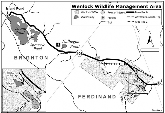
Access to the pond—Moose Bog—is by a spur trail on the left about 0.75 mile along the trail. A new wooden boardwalk and viewing platform were built in the summer of 2016. This is an excellent location to look and listen for Lincoln’s Sparrows, Yellow-bellied Flycatchers, Black-backed Woodpeckers, and Gray Jays. Palm Warblers and Nashville Warblers breed here. If you continue along the main trail, it will merge back onto Route 105. In spring and late fall there may be a few different species of migrating ducks on the pond, but for the most part, Canada Geese, Black Ducks, and Mallards are the summer residents.
Spruce Grouse habitat along Moose Bog Trail.
After you’ve birded the bog pond, return to the main trail. You have two options: If you did not find Spruce Grouse on your way in, trace your route back the way you came—things change every minute, and your luck may improve. Option two is to walk back to the South America Pond Road parking area by way of Route 105. If traffic is light you may be able to hear Boreal Chickadees or a Black-backed Woodpecker as you walk the shoulder. The birding is great along this road, and there are as many boreal species on the north side of Route 105 as on the trail. I often bushwhack into the woods north of Route 105 upon hearing the drumming of Black-backed Woodpeckers. The Nulhegan River is a short distance in and will keep you from wandering too far.
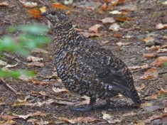
Spruce Grouse.
On South America Pond Road, there is a swamp a little farther down the road from the Moose Bog trailhead. The swamp, on both sides of the road, has Northern Waterthrush, Common Yellowthroat, and Swamp Sparrow. It is also a great place to see and hear Black-backed Woodpeckers drumming on the dead snags. Rusty Blackbirds have been found on the right side of the swamp. There’s a trail on the left just before the swamp, which leads to the back of the swamp and is worth checking out if you haven’t found all of your target birds. The trail eventually winds up in private camps, so I usually take it only to access the rear of the swamp. Beyond the swamp on the right is an old logging access trail, which is a good place to check for boreal species, Ruffed Grouse, and Winter Wren.
For an adventurous side trip from mid-May through October only, Wenlock WMA connects with West Mountain WMA. Take South America Pond Road for several miles connecting with Paul Stream Road, and eventually you will pass Maidstone Lake on the right. The road runs into Route 102 bordering the Connecticut River. You can stop anywhere along these hard-packed dirt roads as they weave through a mix of various conifer and hardwood forests and wetlands. Expect to see at least 15 warbler species as well as flycatchers and thrush species. You can drive the roads with your family car during these months.
Two other birding locations worth checking out along Route 105 while you are in the Wenlock WMA area are:
Moose Viewing Platform and Boardwalk
Halfway between South America Pond Road and the refuge headquarters at Conte NWR —0.75 mile east of South America Pond Road —is a moose viewing platform (point of interest #2 on the Wenlock WMA map), built about five years ago by the Vermont Fish and Wildlife Department. This half-mile stretch of road is known as Moose Alley, and while early morning seems to be the best time to see moose as they browse the muddy wet areas along Route 105, take care while driving along this stretch, as they can be on the roadway any time of day. Pull in on the right at the platform. If you have time, walk or drive down the old logging road. This is one of the entrances to West Mountain WMA. Bearing to the right as you drive or walk the road, you will come to a wide clearing and large power line at 2.4 miles in. I usually try my luck here for Broad-winged Hawks, Indigo Buntings, Rose-breasted Grosbeaks, Ruffed Grouse, and any number of warblers.
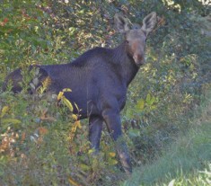
Moose, Wenlock WMA area.
Map and description of Wenlock WMA (pdf)
The Brighton Airport is on the left side of Route 105 at 3.5 miles from Island Pond. There is a sandy road at the extreme east end of the runway that is drivable and will take you to the edge of Nulhegan Pond. Check for Northern Harriers and any shorebirds and waterfowl on the pond. Savannah Sparrow is common and on occasion Vesper Sparrow has been reported here.
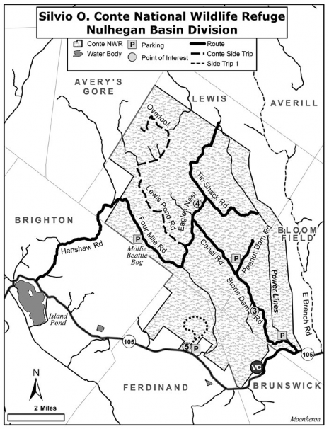
Silvio Conte National Wildlife Refuge, Nulhegan Basin Division
The headquarters and visitor center (marked VC on the Conte NWR map) of the Nulhegan Basin Division of the Silvio Conte National Wildlife Refuge is 1.4 miles east on Route 105 from South America Pond Road, or 10.8 miles from Island Pond. The refuge has some great displays, information, and maps that you will want to have with you as you explore the 44 miles of dirt roads on the refuge. It also has the best bathrooms in Essex County. The refuge is closed to auto traffic from first snowfall through mud season, reopening usually around May 15. Stone Dam Road becomes a snowmobile route, but in early spring if the gates are locked you can park outside—do not block the gate—and walk into the refuge to bird. View road conditions or telephone 877-811-5222.
Entrance to the refuge is a left turn onto Stone Dam Road at 1.9 miles east of the headquarters after you cross the bridge and railroad tracks (12.7 miles from Island Pond). There is a small kiosk on the left side at 0.2 mile, with maps and checklists available. You can park on the shoulder of the road here and begin birding. There is a path on the right side of the road opposite the kiosk that leads to a power line clearing. You can find Rose-breasted Grosbeak, Indigo Bunting, Ruffed Grouse, and a good variety of warblers here, along the roadway, and along the Black Branch of the Nulhegan River on the left side of road. During spring migration there may be surprises such as Wilson’s Warbler, Bay-breasted Warbler, Blackpoll Warbler, Mourning Warbler, and once, Yellow-throated Vireo. At 2.4 miles along Stone Dam Road there is a 10-acre clearing—woodcock and grouse management Unit #1—(Point of interest #3 on the Conte NWR map). Check for Field Sparrow, Indigo Bunting, and Great-crested Flycatcher as well as warbler, vireo, and thrush species. Continue on until you reach a wooden bridge that crosses the Black Branch of the Nulhegan River at 2.8 miles. This is a good place for Northern Parulas, Blackburnian and Nashville warblers, American Redstarts and, on occasion, Tennessee Warblers migrating through.
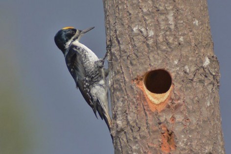
Black-backed Woodpecker.
Peanut Dam Road
On the right side of the road at 4.2 miles, you’ll find an old logging trail, Peanut Dam Road. Park in the short pull-off, then walk the one-mile dead-end trail. The habitat is mostly larch, spruce, and fir. Boreal Chickadees have bred here, Gray Jays and Black-backed Woodpeckers can be found, and Spruce Grouse occasionally are seen along the trail. Warblers include Yellow-rumped, Magnolia, Nashville, Black-throated Green, and Northern Parula. Bob Stymeist, leading a field trip here in June, 2015, found a male Cape May Warbler—hinting at possible breeding of the species at this location!
Stone Dam Road becomes Canal Road and then intersects with Eagles Nest Road at 6.8 miles. You have two options. Option one: Turn right, and in another 0.4 mile you will find a marshy area on the left (point of interest #4 on the Conte NWR map). Check for Rusty Blackbird and Common Grackle. Keep in mind that you still can find any of the four boreal species on any of these roads in the refuge. At one mile along Eagles Nest Road, you’ll come to a “T’ intersection after a wooden bridge. You can bird Upper Tin Shack Road by turning left or Lower Tin Shack Road by turning right. These are old logging roads but are drivable with your car. Lower Tin Road seems to have more coniferous or boreal habitat.
Mollie Beattie Bog
Option two: I tend to turn left at the intersection of Canal and Eagles Nest Roads. Drive for 1.1 miles and you will reach another “T” intersection with Lewis Pond Road (7.9 miles from the entrance). Make the left onto Lewis Pond Road and in 0.7 mile (8.6 from the entrance) you reach a 30-acre clearing, which is another woodcock and grouse management area. You can often see Northern Harriers here along with Mourning Warblers. Turn right onto Four Mile Road. In another 1.4 miles, there will be parking on the left for Mollie Beattie Bog. A boardwalk and viewing platform are on the right. Expect to have Gray Jays and Black-backed Woodpeckers visit as a Palm Warbler or two sing nearby. Magnolia Warblers, Ruby-crowned Kinglets, Red-breasted Nuthatches, Swamp Sparrows, and Lincoln’s Sparrows are also around.
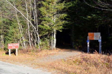
Mollie Beattie Bog trailhead.
For a shortcut back to Island Pond, continue on Four Mile Road and it will run into the Henshaw Road access. This is the back entry into the refuge. It is a 6-mile drive from Mollie Beattie Bog out to Route 105 using this route. Also, birding can be good along this road.
Side trip: At the intersection of Eagles Nest and Lewis Pond Road, turn onto Lewis Pond Road to reach Lewis Pond and the Lewis Pond overlook. While Lewis Pond may not have any waterfowl, Black-backed Woodpeckers have nested along the shoreline, and the views from the overlook are spectacular, especially in the fall.
North Branch Trail
There is one other trail on the Conte refuge that is worth a visit, especially during fall migration. From the Island Pond stop sign, head east on Route 105 for 7.3 miles. Or from the refuge headquarters, head west on Route 105 for 3.5 miles. A small parking lot for 3 or 4 cars is on the north side of the road. The North Branch Trail (point of interest #5 on the Conte map) is a 3.5-mile loop trail that travels through mixed habitats and runs along the south side of the Nulhegan River for at least half of the distance. In September, Bay-breasted, Blackpoll, Cape May, and Tennessee warblers, along with Philadelphia Vireos, have been found foraging along this trail. Good numbers of Red-eyed Vireos and a few flycatchers and Ruffed Grouse are also found here.
Link for map of Silvio O. Conte NWR
Bonus Birding Sites in Northeast Essex County (See map for overview)
Side Trip #1: Plum Creek Timber Lands (Also see Silvio O. Conte NWR map)
Plum Creek Timber Company owns several thousand acres of land in the Northeast Kingdom. The State of Vermont holds easement rights to these lands, and they are open to the public for hiking, birding, hunting, and recreation. The roads are somewhat maintained by the timber company and access to many of these roads can be done in the family car. From the Stone Dam Road entrance of Conte NWR, drive another 0.9 mile east on Route 105 (13.6 miles from Island Pond), then turn left onto East Branch Road. This is just before the bridge that crosses the East Branch of the Nulhegan River. The trip is a 15-mile-long drive through a mix of coniferous and hardwood forests, much of it in successional growth after decades of timber harvest. The good news is that young forests are great for migrating spring and fall warblers. Stop anywhere along the dirt road and see what each particular slice of habitat may offer. At 3.1 miles along the road, cross a wooden bridge and bear left toward Averill/Norton, staying on the main road. You will find a few coniferous areas at 6.5 miles that may be a good place to check, as Spruce Grouse were reported here in summer of 2015. At 9 miles, continue straight—north—toward Averill. At about 15 miles, you merge with Jackson Road. There is a Vermont Fish and Wildlife access for Little Averill Pond if you choose to see what may be on the pond. Otherwise, continue on Jackson Road to Lake Averill and merge onto Route 114, heading west and then south back to Island Pond.
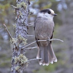
Gray Jay, Moose Bog.
Side Trip #2: Brighton State Park, Spectacle Pond, and Island Pond Access (Also see Wenlock WMA map)
From the stop sign in Island Pond (point of interest #1 on the Wenlock WMA map), drive 1.6 miles east on Route 105. Turn right onto Lakeshore Drive and, after the railroad tracks, make a left onto Fishing Village Road. A Vermont Fish and Wildlife access is located ahead. Check for Hooded Mergansers, Ring-necked Ducks, and Common Loons. You will find Brighton State Park and the town beach 0.8 mile from Route 105 along Lakeshore Drive. Another Vermont Fish and Wildlife access at 1.4 miles is beyond the beach area on the right. In fall months, you will find migrating waterfowl here, including Common Goldeneyes, Red-breasted and Common mergansers, Buffleheads, both scaup species, and all three scoter species. Occasionally, you will see Horned Grebe and Red-necked Grebe. You can often see Bald Eagle in the fall.
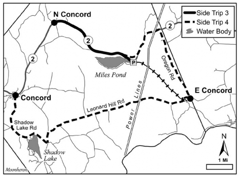
Side Trip # 3: Miles Pond and East Concord (Also see Side Trips 3 and 4 map)
Miles Pond is a neglected hotspot for birding. From the North Concord intersection, drive 3.1 miles east on Route 2 to Beach Drive on the right. There is a dirt road, Camper’s Lane, on the extreme east end of Miles Pond. Park on the right in front of the town beach and picnic area. The trail for birding is located on the railroad tracks—no longer in use—that head eastward away from the pond. While at the pond area, spend a few minutes to look for Common Loons, Spotted Sandpipers, Baltimore Orioles, Warbling Vireos, and other lakeside passerines.
The old railroad tracks run from Miles Pond to the village of East Concord almost four miles away. If you have two cars, you can leave one at Miles Pond and the other at East Concord where the tracks come out, and walk this trail one way. In summer months, the trail on these tracks can have thorny growth and may be hard to navigate, but persevere and you will be glad you did. You will pass through a mix of habitats including marsh, conifers, hardwoods, and successional growth. In spring, you can find any of the 20 warbler species that migrate through here, including many Canada, Chestnut-sided, and Nashville warblers. Our Audubon chapter often starts our Bird-a-thon here and we can find 60 species. Wood Thrush, Hermit Thrush, and Winter Wren are common, as are Blue-headed and Red-eyed vireos, Rose-breasted Grosbeak, and Great-crested Flycatcher.
About halfway along the rail trail, you will come to a power line that bisects it. Ospreys have nested atop the poles here, and Marsh Wrens and Olive-sided Flycatchers have been found close by. An ATV/snowmobile trail runs beneath the power lines. Walk in either direction for a few hundred yards, and Mourning Warbler may be your reward. After you cross the trestle past the power lines, the terrain on the right side of trail will be more upland, and on the left side of the trail Miles Stream forms eddies and wetlands below. Openings through the brush reveal waterfowl,ingfishers, and perhaps Olive-sided Flycatchers as well. The railroad bed gets overgrown with vegetation but is still manageable with proper clothing and boots.
Side Trip # 4: Leonard Hill Road: Whip-poor-wills (Also see Side Trips 3 and 4 map)
If you are in the Kingdom in late May and June, East Concord has one of the best locations for hearing Whip-poor-wills. Wait till the moon has risen above the horizon for at least an hour, preferably closer to a full moon. A short mile or so east on Route 2 from Miles Pond, turn right onto Oregon Road, and follow it for 3.0 miles into the village of East Concord. Bear to the right on Cedar Street and take Leonard Hill Road up the hill over a small concrete bridge. Prime Whip-poor-will habitat runs from 1.5 miles through 3.5 miles along Leonard Hill Road. I’ve done surveys here for 10 years and always find two to five birds. The best place to stop and listen is where the high voltage power lines cross Leonard Hill Road, at about 2.0 miles. Listen for Northern Saw-whet Owls and Barred Owls, also. I often get each of them as I drive this dirt road. Common Nighthawk is possible in spring and fall as well. If you choose, you can continue on Leonard Hill Road for another eight miles through the village of Concord Corners where you’ll make a right turn onto Shadow Lake Road, pass Shadow Lake, and merge into the town of Concord and Route 2.
Side Trip # 5: Northern Essex County Ponds
North of Island Pond, there are five ponds along Route 114 on or a few miles south of the Canadian border that provide waterfowl stops during fall migration. Beginning in mid-September and well into November, any one of these ponds may attract several species of migrating waterfowl. In the spring, these ponds remain frozen until late April so there is less of a chance of finding waterfowl migrating north. In the fall of 2016, I surveyed these ponds regularly and was able to find all three scoter species; all three merganser species; Horned, Red-necked and Pied-billed grebes; both scaup species; along with Ring-necked Duck, Long-tailed Duck, Common and Red-throated loons, Common Goldeneyes, Buffleheads, Ruddy Ducks, Green-winged Teal, Black Ducks, and Mallards. I was also able to find Brant, Snow Geese, Canada Geese, and Bonaparte’s Gulls. Migrating waterfowl find these ponds inviting enough for a short visit. Short is the key word here, as some birds remain only a few hours before moving on, so timing a trip to these ponds can be hit or miss. One day I had close to 1000 birds among the five ponds and the next day fewer than 50.
Starting at the blinking red light at the intersection in Island Pond (point of interest #1 on the Wenlock WMA map), turn left onto Route 114 and head north. At 0.2 miles, Meadow Street is on the left after you cross a small bridge. This is a good place to stop for a variety of birds year-round. The half-mile dirt road dead-ends at the town’s sewage treatment plant. In spring and fall I always check for shorebirds and waterfowl on the two ponds behind the chain link fence. There are a few industrial buildings along the road with several crab apple trees that are worth checking for Pine Grosbeak, Bohemian Waxwing, and Evening Grosbeak during late fall and winter. At least three homes have a few feeders up from November through April. During the winter of 2016, at least 120 Evening Grosbeaks came to the feeders of the house at the corner of Meadow Street and Route 114.
Continue north on Route 114 for 7.5 miles to Hurricane Road on the left. This dirt road leads to a marsh and beaver pond surrounded by a conifer mix of spruce and balsam fir. It is good in the spring for warblers, a few duck species, blackbirds, and the usual woodpecker, kinglet, and nuthatch species. Do not take this road any farther than the pond as it dead-ends at private homes. Return to Route 114.
At 19.5 miles from the Island Pond intersection, turn right onto Jackson Road, the turnoff for Little Averill Pond. This dirt road is open only from late spring to late fall. After five miles of dirt road, you’ll arrive at a boat launch and fishing access on the east end of the pond, which is great for kayaking in the fall. To stay on Jackson Road, always bear to the right.
Return to Route 114 and travel north 0.5 mile, turning right onto Lakeview Road, which passes along the northern shoreline of Great Averill Pond. Pull over at any clearings to get scope views of the pond. Another pond that is off the beaten track is Forest Lake. Return to Route 114 north, and in 0.1 mile turn right onto Forest Lake Road. The lake is really a small pond, located 1.6 miles on the right. Check for dabbling ducks in the fall. I have had Boreal Chickadees along the conifer shoreline while scoping Forest Lake.
Four miles up the road from Great Averill Pond is Wallace Pond (24.6 miles from the Island Pond intersection). This 540-acre pond straddles the border with Canada and is the first body of water in the northeastern section of Vermont that migrating waterfowl see as they fly south. There is a Vermont Fish and Wildlife access road on the western end of the pond, but visibility to the pond is not good at that location. I prefer to pull off the road halfway along the pond and scope through the open areas between homes along the shoreline. Many of these homes are summer camps, so during the fall months you won’t be interfering with owners’ privacy. On the eastern end of the pond, there is a wide opening for scope views of the pond. Wallace Pond is, in my opinion, the best pond for finding waterfowl in Essex County. During the fall, plan to stay at least a few hours at this location. As I stated earlier, the birds seem to come and go, so each time you re-scope there is a good possibility that something new and different has arrived.
Thomas Berriman moved to the Northeast Kingdom of Vermont in 2002 after living in San Francisco for 25 years. He has spent a good deal of the time since birding that area of Vermont. He is an Audubon chapter president and leads several field trips throughout Vermont each year. Over the last five years, he has honed his skill in digiscoping the birds he finds.