Peter Crosson
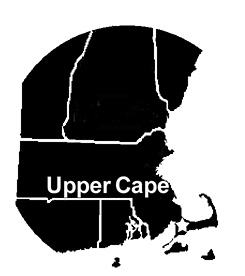 Birding Cape Cod in winter can be an absolutely wonderful experience. The moderate maritime climate means warmer winter days, allowing for more overwintering passerines than on the mainland. Ponds often have open water even late into winter, and the many miles of coastline hold wintering waterfowl. Upper Cape Cod comprises the towns of Bourne, Sandwich, Mashpee, and Falmouth. For the visiting birder, the Upper Cape is much closer than the remote beaches of the Outer Cape, and you can find several specialties of the peninsula more easily in this productive area. This article focuses on the Upper Cape and Barnstable west of Route 149, including the small sliver of Cape Cod on the mainland side of the canal. Although not as visually stunning as the Outer Cape’s dramatic beaches, Upper Cape Cod is a lovely and varied area that holds a wealth of avian diversity.
Be aware that, although the thermometer might read higher on the Cape, the winds can be brutally cold, especially when from the northwest. Be prepared with warm clothes and appropriate cold-weather gear. One oft-forgotten piece of clothing that can be a lifesaver when the wind is up is a balaclava to protect your face and neck from bitterly cold gusts. A scope is highly recommended for sea watching and for checking ponds. Public beaches are accessible without a fee in winter, and traffic is not a problem. This area of Cape Cod is fairly populous, so there is no shortage of restaurants, motels, or gas stations open year-round.
This article divides the Upper Cape into seven sections, all featuring geographically close hotspots. You should be able to cover each section in a few hours to a half-day of birding. Although there is some variability among the regions, there are certain specialty birds that you are more likely to encounter in each one, which I indicate at the beginning of each section. If you want to target certain species, use these groupings to increase your chances of hitting your targets. Checking recent eBird sightings in these areas can also help tremendously.
The Upper Cape has three major highways that access the birding spots. Route 6, the mid-Cape highway, runs east from the Sagamore Bridge through Sandwich and Barnstable to the Outer Cape. The quieter Old Kings Highway, Route 6A, weaves east through a beautiful and productive region of marshes, beaches, and thickets on the north side of the Upper Cape. The western portion of Route 6A, known as the Scenic Highway, runs west along the Cape Cod Canal, linking the Sagamore and Bourne bridges. Route 28 heads south from the Bourne Bridge, provides access to Falmouth, and loops around to Mashpee and the southern side of Barnstable. Note that on Route 28 the highway signs can be confusing; although it is marked as Route 28 South, it heads northeast as it leaves Falmouth.
Several other main roads link the birding sections of the Upper Cape. Route 151 heads east from southbound Route 28 in North Falmouth, passes through inland Falmouth and Mashpee, and terminates at Route 28 at the Mashpee rotary. Two north-south roads, Routes 130 and 149, connect Route 6A on the north side of the Cape to Route 28 on the south side. Route 130 runs from Sandwich to Mashpee. Route 149 connects the northern end of Barnstable to its southern end and forms the approximate eastern boundary of the Upper Cape birding area, although I have included a few spots that are a short distance east of Route 149.
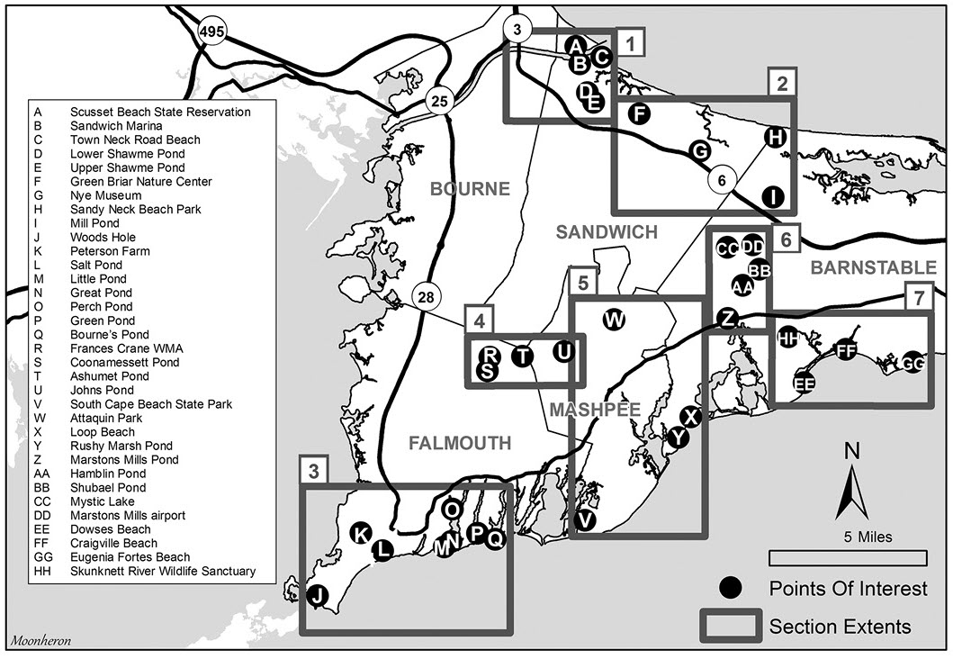
1. Sandwich and the Cape Cod Canal
This section centers around the eastern mouth of the Cape Cod Canal, which winds through the northwest corner of the town of Sandwich. Thousands of waterfowl winter here, often providing opportunities for close viewing. Sandwich also includes a pair of productive inland ponds. Sought-after birds include King Eider, Harlequin Duck, Razorbill, and Great Cormorant.
Scusset Beach State Reservation (A) lies in the small corner of Sandwich known locally as the village of Sagamore, on the mainland side of the canal. From Route 3 South, take Exit 1A- Scusset Beach Road/US 6 West, turn left at the fork onto Scenic Highway, and follow signs for Scusset Beach Road. Travel 1.3 miles to the main entrance. You can stop in 0.25 mile at the fishing pier for one view of the canal; otherwise, continue east past the campground to the main parking lot where you can access the campground, beach, and mouth of the canal. This is one of the top birding hotspots in the area, with nearly 250 species recorded in eBird. The bike path paralleling the canal provides unrivaled close views of wintering waterbirds. Large rafts of Common Eider often forage just off the banks of the canal; sift through them for King Eider. Razorbills feed in the canal in small numbers at times and occasionally are joined by a murre or guillemot. Great Cormorants roost on buoys or on pilings in the canal. The thickets in the campground area may hold a variety of wintering passerines, and the barren field adjacent often has Horned Larks and occasionally Snow Buntings or a Lapland Longspur.
Returning to Route 3, cross the Sagamore Bridge, and take Exit 1C-6A Sagamore. Turn right on Route 6A. In 1.9 miles, turn left onto Tupper Road, and in 0.4 mile, turn left onto Freezer Road to enter the Sandwich Marina (B) and the Cape Cod Canal Visitors Center. You will see many of the waterfowl you saw at Scusset, although at a greater distance. There are often good numbers of gulls roosting here that may include Iceland, Glaucous, or Lesser Black-backed gulls. Brant often forage on the grassy field adjacent to the parking lot. In the marina, you may get close looks at Common Loon and Red-breasted Merganser. Common Raven has nested at the adjacent power plant and is seen year-round.
Section 1 detail.
Exiting the marina from Gallo or Coast Guard roads, turn left on Town Neck Road, and in 0.1 mile reach Town Neck Road Beach (C). There can be tremendous numbers of waterfowl offshore, occasionally numbering into the thousands. This is another good spot to look for King Eider and the occasional Harlequin Duck. Sharp-eyed observers may spot a Purple Sandpiper on the large breakwater or an alcid among the waterfowl. Ruddy Turnstones often forage on the rocky beach. This can also be an excellent spot to watch for storm-blown birds during a northeaster.
A pair of productive ponds for dabbling ducks, Lower and Upper Shawme ponds (or lakes—the terms are used interchangeably), round out this section. Return to Tupper Road and turn left. In 0.6 miles cross Route 6A at the traffic light and continue on Tupper Road for another 0.4 mile, then turn right onto Route 130 and take an immediate left onto Grove Street, which parallels Lower Shawme Pond (D). You can check the pond from Grove Street, but it is a narrow street with only a few places you can pull over to see the water. Drive slowly and respect the private residences.
Upper Shawme Pond (E) is not easily viewed from the road, but best observed from a short hiking trail in Cooks Farm Conservation Land, a 0.7-mile drive south on Route 130, across from the Wing School where you can park. Both ponds can have good numbers of dabblers, including rarer species such as Eurasian Wigeon and Northern Shoveler. Cooks Farm also has productive thickets for overwintering songbirds. Uncommon passerines such as Fox Sparrow, and Yellow-bellied Sapsucker have been found here.
2. East Sandwich to West Barnstable
From Cooks Farm, retrace your route to the junction of Tupper Road and Route 6A. Turn right and head east on Route 6A, which winds through a lovely stretch of cranberry bogs, marsh, and forest. This area holds many productive nooks and crannies, and simply wandering back streets looking for birds can be great fun. The crown jewel of this section is Sandy Neck Beach Park, but other hotspots along the way can hold many interesting surprises. Target birds here include Snowy Owl, Northern Shrike, Eurasian Wigeon, and Blue-winged Teal.
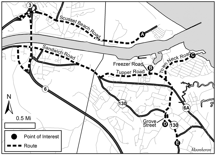
King Eider. All photographs by the author.
At 2.1 miles from the Tupper Road intersection, you will encounter the first hotspot along Route 6A, Greenbriar Nature Center and Jam Kitchen (F), a charming property with wonderful wet thickets, a small but productive pond, and beautiful hiking trails through a mixed woodland. Turn south on Discovery Hill Road, which is marked with a sign for the nature center. The thickets around the visitor center and along Discovery Hill Road can hold a variety of wintering passerines, and the pond usually has Common Goldeneye and Hooded Merganser. The rich woods are good for Winter Wren and Fox Sparrow; Yellow-bellied Sapsucker has wintered here. While at the property you can visit their resident rabbits or purchase some delicious homemade jam.
Return to Route 6A and turn right, head east for 1.6 miles, then take a right turn on Old County Road. In 0.8 mile, the Nye Museum (G) will be on the left. The museum complex includes the Old Fish Hatchery, an interesting and often productive birding spot. The area is full of low, wet thickets, which are usually good for overwintering passerines. Some of the more interesting birds seen here on occasion include Rusty Blackbird, Ruby-crowned Kinglet, Winter Wren, and Wilson’s Snipe. The marshy tidal pond can hold Virginia Rail, Swamp Sparrow, and occasionally a few Green-winged Teal or Greater Yellowlegs. Across the street, birders are welcome to visit Nye Pond, private property that is managed by the Nye Museum. Nye Pond can be good for dabbling ducks and often stays open even when other ponds are frozen. Eurasian Wigeon has been found here a few times.
Backtrack to Route 6A and turn right. Stay on Route 6A for 2.3 miles, then turn left on Sandy Neck Road to Sandy Neck Beach Park (H), the premier year-round birding hotspot on the Upper Cape, with almost 270 species recorded on eBird. In winter, Sandy Neck is a good place to look for a wide variety of wintering waterfowl, gulls, and shorebirds. Twelve species of gull have been seen here, including Little, Glaucous, and Black-headed. Snowy Owls are found here most years, though often they roost out on the tip, a nearly six-mile walk from the parking lot. You can find Northern Shrike in the dunes near the parking lot or along the ORV trail, which hikers may walk. Short-eared Owls may emerge from the dunes at dusk to feed out in the marsh. A platform looks out over the dunes from the upper parking lot, providing a good spot from which to scope for shrike or owls. You can often find the “Ipswich” subspecies of Savannah Sparrow in the parking lot. During winter northeasters, alcids, gannets, and kittiwakes may be blown in close to shore. If you walk the trails, be aware that hunting is popular here, so Sunday is the only safe day to walk on the marsh side.
After leaving Sandy Neck Beach State Park, turn left onto Route 6A, drive for 1.4 miles, then turn right onto Maple Street. Mill Pond (I) sits between Maple Street and Willow Street in West Barnstable, just south of Route 6A. Viewing the pond from Maple Street is difficult; the best access is via a small hiking trail off of the cul-de-sac on Gemini Drive, a residential neighborhood. To reach Gemini Drive, head south on Maple Street for 0.8 mile and turn left on Cedar Street. Gemini Drive is on the left in 0.1 mile. It ends at the bottom of the hill in a circular cul-de-sac, from which the trail heads into the woods. Please be respectful of the neighboring homeowners when using this trail. The small arm of the pond that borders the trail is often the most productive area and frequently has wintering Blue-winged Teal, and occasionally Northern Pintail or Wood Duck. The main pond is good for a variety of waterfowl, including Ring-necked Duck, Hooded Merganser, and Bufflehead. Great Blue Herons often roost in the trees surrounding the pond.
3. Coastal Falmouth
Falmouth is, without a doubt, the duck capital of the Upper Cape. The wide variety of inland ponds and coastal salt ponds attracts an interesting mix of diving and dabbling ducks as well as other waterbirds. Many rarities have been found in these ponds over the years. Targets include Tufted Duck, Redhead, Canvasback, and Barrow’s Goldeneye. In addition, the area is blessed with abundant thickets that provide habitat for overwintering passerines.
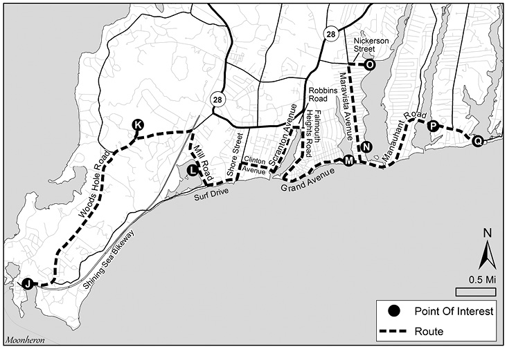
Section 3 detail.
Start your coastal Falmouth birding in Woods Hole (J), the farthest southwest point, and work your way northeast from there. To reach Woods Hole from off-Cape, follow Route 6A west from the Sagamore Bridge for 5.4 miles to the Bourne Rotary. Or, if you cross the Bourne Bridge, this is where you will begin. Take the exit onto MA-28 S/MacArthur Blvd toward Falmouth/Woods/Hole/Martha’s Vineyard. At the next rotary, take the second exit to continue on Route 28 south to Falmouth/Woods Hole. Follow Route 28 south for approximately 9 miles until it turns into Palmer Avenue. As you continue south, the road’s name changes to Woods Hole Road. In another 4.7 miles you will reach Woods Hole, home of the Woods Hole Oceanographic Institute, a charming little village that can be a lot of fun to poke around in winter. Nobska Point Light and Nobska Pond are worth visiting for raptors and puddle ducks. The Great Harbor area is good for sea ducks, Great Cormorant, and occasionally Purple Sandpiper, and there are many productive thickets around town. There is also a free aquarium that can provide a break from the cold. Be aware that parking is usually metered and is enforced year-round.
A few miles north from Woods Hole, Peterson Farm (K) is a parcel of land managed by the Falmouth 300 Committee land trust. Drive north on Woods Hole Road for 2.9 miles, and turn left on MacCallum Drive. Immediately take a sharp right up a steep, narrow road to the farm. Formerly a working farm, the area still has open agricultural lands and large thickets ringing its perimeter, all of which may be productive. Eastern Phoebe is often found here in winter, and this is a good spot for Fox Sparrow and Yellow-breasted Chat. Eastern Meadowlark may forage in the grassy fields. Accipiters frequently hunt the area.
Leave Peterson Farm and continue north on Woods Hole Road for 0.7 mile, then take a sharp right onto Mill Road. This road parallels the eastern shore of Salt Pond (L), perhaps the most productive of Falmouth’s many coastal ponds. Common Goldeneye is usually here in good numbers and may be accompanied by one or more Barrow’s Goldeneye. Occasionally, large flocks of scaup form, and Tufted Duck has been found among them. Common Loon, Red-breasted and Hooded mergansers, and Bufflehead are almost always present. In 2019, a Pacific Loon visited for a couple of days. Shining Sea Bikeway runs along the western shore of the pond and has excellent thickets which often shelter Yellow-breasted Chat, Ruby-crowned Kinglet, and Fox Sparrow.
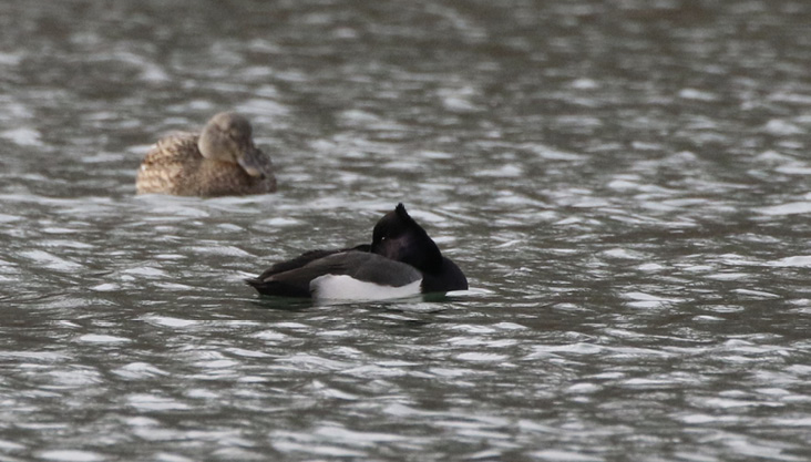
Tufted duck x scaup hybrid.
From Salt Pond, continue to the end of Mill Road, turn left, and follow Surf Drive for one mile, bearing left where it becomes Shore Street. Turn right on Clinton Avenue and follow it for 0.5 mile, then turn left at Scranton Avenue. This takes you past the Falmouth Marine Park, which may be worth a quick look for ducks. Continue north on Scranton Avenue for 0.3 mile, then turn right on Robbins Avenue and right again onto Falmouth Heights Road. Return south along Falmouth Heights Road—which becomes Grand Avenue when it loops around Falmouth Heights—and follow the coastline 1.4 miles to Menauhant Road, where you bear slightly right to stay along the shore. Little, Great, Green, and Bourne’s ponds are a series of narrow, brackish ponds that radiate north from Falmouth’s south shore like fingers. All kinds of waterfowl are possible in these ponds, which often stay unfrozen when other ponds are iced over.
Little Pond (M) in particular can be good for large flocks of scaup, which occasionally include Redhead or Canvasback. View this pond from a small parking area at its outlet on Menauhant Road known as Bristol Beach. Drive east on Menauhant Road for 0.5 mile to the outlet of Great Pond (N) into Nantucket Sound, where Barrow’s Goldeneye and Purple Sandpiper have been somewhat regular. To explore both ponds further, head up Maravista Avenue, where the side streets will give you nice vantages. Take Boston, Brockton, or Pocasset streets west to view Little Pond, or just about any street east to Great Bay Street, which parallels Great Pond. Perch Pond (O) is a northwest extension of Great Pond. It has been the best place on Cape Cod for Canvasbacks, though they have not been seen here since 2017. Redhead is occasionally found at Perch Pond. Scaup can be numerous, and Tufted Duck is a possibility. In 2020, a hybrid Tufted Duck x scaup was found. The best spot for observing this pond is a small conservation area at the east end of Nickerson Street, a right turn off Maravista Avenue 1.3 miles north from Menauhant Road. To continue your coastal birding, drive back to Menauhant Road and head east to Green (P) and Bourne’s (Q) ponds, which you can bird from the main road or nearby side streets.
When you have finished birding coastal Falmouth, this might be a good time for a lunch or coffee break. There are several lunch spots along Falmouth’s Main Street. If you go into Falmouth, consider birding Sider’s Pond, an inland pond just behind Falmouth’s Town Hall building, that can host large flocks of scaup and is worth checking for more rare species. Tufted Duck was found here in 2015; Canvasback and Redhead have been seen here as well. Pied-billed Grebe, Ring-necked Duck, and Canada Goose are common here, and the large thickets bordering the town hall area can be productive.
4. Inland Falmouth and Mashpee
Birding the inland section of Falmouth and Mashpee centers around the Route 151 corridor. This is a nice area to explore if the wind is up and coastal birding is uncomfortable. There are unique habitats here that can harbor unusual species for the Cape. Target birds include Barrow’s Goldeneye, Eastern Meadowlark, Northern Shrike, and Barred Owl.
This section begins at the Frances Crane Wildlife Management Area (WMA) (R), which you can reach from off-Cape or downtown Falmouth, depending on where you started your birding day. From Falmouth’s Town Hall Square, turn left—heading west on Main Street—for 0.3 mile, then turn right onto Palmer Avenue. In 2.1 miles, merge onto Route 28 North, continue for 4.4 miles, then take the Route 151 exit and head east toward Mashpee and North Falmouth. From off-Cape, take the Bourne Bridge to Route 28 South to Exit 151 and head east. Drive on Route 151 for 2.4 miles until you see Hamilton Tree and Landscape on your left and a small baseball diamond just beyond it. Turn left before the baseball field into the parking area for Crane WMA.
The main field complex is the largest open grassland on the Cape outside of the Joint Base Cape Cod, which is adjacent to Crane WMA. On a cold, windy winter day this can be an incredibly bleak place. However, Eastern Meadowlarks overwinter here, and it is an excellent place to look for Northern Shrike. Rare winter passerines such as Vesper Sparrow and Palm Warbler are sometimes seen. A Mountain Bluebird was found in 2016. Short-eared Owls are occasionally found in the evening. Hunting is popular, so Sunday is the only safe day to bird.
Coonamessett Pond (S) lies 0.5 mile due south of Crane. Directly across Route 151 from the Crane parking area, take Ranch Road 0.3 mile to Boxberry Hill Road, turn right, and look for a parking lot on the left in 400 feet. Walk down a small path near the edge of the golf course. This path has some thickets that may yield Winter Wren or Fox Sparrow, and the golf course often attracts Eastern Bluebird. The pond is good for Common Merganser, scaup, and occasionally large flocks of Canada Goose. A pair of Greater White-fronted Geese was here in 2016.
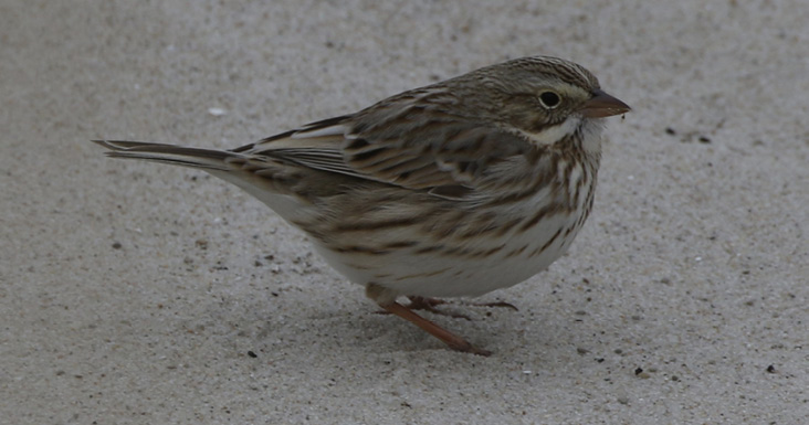
"Ipswich" Sparrow
Return to Route 151, turn right, and head east for 1.5 miles, then turn left onto Currier Road to reach Ashumet Pond (T), where you can make two birding stops. This is one of the best places on the Cape to find Barrow’s Goldeneye; there is at least one almost every winter and, occasionally, a hybrid Barrow’s x Common goldeneye. Sometimes there are large numbers of American Coot, which Bald Eagles target for a snack.
Viewing the southern end of the pond can be a little tricky; your best bet is to drive 0.4 mile to Austin Stokes Road, park there, and carry your scope across Currier Road to the small beach adjacent to the road. This is the place to look for Barrow’s Goldeneye. The north section of the pond is easy to view from the Ashumet Pond boat ramp. From Austin Stokes Drive, follow Currier Road north for 0.5 mile, turn right onto Sandwich Road, and turn right into the parking lot.
For Johns Pond (U), exit the parking area and turn right onto Sandwich Road, which becomes Back Road in 0.4 mile when the road curves right. Follow Back Road for 0.6 mile and bear left at the fork to stay on Back Road for another 0.5. mile, where it ends at Johns Pond Park. This is a fascinating area of trails that wind through an old, mostly overgrown cranberry bog and can be productive for overwintering songbirds, including Swamp Sparrow and Winter Wren. You could startle up a Ruffed Grouse. This is one of the better spots to find Barred Owl on the Upper Cape, and they are sometimes vocal during the day. The cattail marsh often harbors overwintering Virginia Rails. Johns Pond may have good numbers of waterfowl, and there is also a small pond north of the parking area where you may find Hooded Merganser.
5. Coastal Mashpee and Cotuit
If you have been birding the south coast of Falmouth and want to continue along the coast, Mashpee and Cotuit offer some attractive destinations. Head northeast from Main Street Falmouth on Route 28 South (yes, it is confusing), which winds through pretty residential villages and past the grounds of the Waquoit Bay National Estuarine Research Reserve (WBNERR), an interesting facility open to the public for natural history programs. In 8.8 miles you will arrive at the Mashpee rotary, where good birding spots await in three different directions. If you have been birding Frances Crane WMA and the nearby ponds, drive east on Route 151 to the Mashpee rotary. Targets in the coastal Mashpee and Cotuit area include Snowy Owl, Barrow’s Goldeneye, Virginia Rail, and Bald Eagle.
Whichever way you enter the rotary, exit onto Great Neck Road South. This scenic road winds 5.4 miles past Wampanoag tribal land and turns into Great Oak Road on the way to South Cape Beach State Park (V). One of the area’s prime birding spots, South Cape Beach consists of the Mashpee town beach to the west and the state park beach to the east. The town beach abuts an extensive salt marsh and can be good for Snowy and Short-eared owls. A sand trail heading west leads out to a large jetty, a one-way trip of about 1.5 miles. The sand trail passes Sage Lot Pond, several salt ponds, and dunes frequented by Horned Lark, Snow Bunting, and the “Ipswich” subspecies of Savannah Sparrow. Purple Sandpiper and other shorebirds are possible at the jetty.
At the state beach, walk east to Flat Pond, which abuts the New Seabury golf course, and look for waterfowl. Barnstable County’s first Ross’s Goose was found here in 2019. The Nantucket Sound shoreline is modestly productive but worth checking.
Return to the rotary. Take the second exit onto Great Neck Road North. In 2.7 miles, turn left onto Route 130, then turn right in 0.1 mile onto Lake Avenue, which ends at Attaquin Park (W). This parking area looks out over Mashpee-Wakeby Pond, an excellent place to scope for diving and dabbling ducks. You can usually find at least one Barrow’s Goldeneye and occasionally hybrids with Common Goldeneye. Bald Eagles frequent Mashpee-Wakeby Pond as well. Look for Great Blue Heron at the marshy pond at the entrance on Lake Avenue and explore its bordering wet thickets.
Head back to the Mashpee rotary, and take the fourth exit, Route 28 South. In 0.3 mile, turn right onto Quinaquisset Avenue, and drive 3.4 miles east past Willowbend Golf Course into the town of Cotuit. At Main Street, turn right and proceed 0.2 mile to a stop sign. Turn left onto Ocean View Avenue and drive 0.3 mile past stately homes to Loop Beach (X). This spot provides a view of Mass Audubon’s Sampsons Island and an open panorama of Cotuit Bay. There can be numerous Common Loons and Common Goldeneyes as well as an occasional Barrow’s. Scope Sampsons Island for a possible Snowy Owl.
Continue on Ocean View Avenue for 0.1 mile and turn left to rejoin Main Street. Follow Main Street for 1.1 miles to Rushy Marsh Pond (Y). This is a good spot to look for overwintering Virginia Rail and Marsh Wren. Hooded and Red-breasted mergansers are frequently present. The beach at the end of Main Street offers another vantage over Nantucket Sound.
6. Marstons Mills Ponds and Conservation Areas
The village of Marstons Mills, part of the town of Barnstable, contains a constellation of lakes and ponds that can be good for waterfowl. A spotting scope is recommended for optimal viewing of the larger ponds. The area includes a grassy airfield and one of the larger wooded conservation areas on the Cape. Target birds include Bald Eagle, Northern Shrike, Eurasian Wigeon, and Snow Goose.
If you are coming from Rushy Marsh Pond, take Main Street in Cotuit north until it ends at Route 28. Turn right and continue on Route 28 South for 2.1 miles, then turn left at the traffic light onto Route 149. If you are coming from the Mashpee Rotary, exit onto Route 28 South, which you will follow until the left turn onto Route 149. Immediately park on the right side of the road across from Marstons Mills Pond (Z). Parking is allowed in the widened areas on both sides of Route 149. Carefully cross Route 149 to view the pond. Bring your scope.
Historically, this has been one of the best ponds for dabbling ducks on the mid-Cape. Snow Goose, Eurasian Wigeon, and Northern Shoveler have been seen here regularly; during one fierce blizzard, an Eared Grebe spent a day on this pond. The entire main street of Marstons Mills, including the access to the pond, underwent a major renovation in 2019, and the number of ducks seems to have dropped off dramatically since then. Whether that was a one-year anomaly or will be the start of a trend remains to be seen.
The next stop is Hamblin Pond (AA). Bald Eagles are frequently spotted here. A wide variety of dabbling and diving ducks, loons, and grebes has also been seen over the years. There are two places to access the water from Route 149, and both are easy to miss. For the Hamblin Pond Beach and boat ramp, drive north on Route 149 from the Marstons Mills Pond for 0.7 mile, and turn left at the small sign for Hamblin Pond Beach just before the Marstons Mills Cemetery (70°24’37.29”W 41°39’46.98”N). To reach the second spot, the Hamblin Pond car top boat launch, drive north on Route 149 for another 0.7 mile, and turn left onto an unmarked gravel road just before Laurel Drive (70°24’19.20”W 41°40’0.82”N). Parking is available along the access road, with space for approximately 6 cars.
Returning to Route 149, head north for 1.1 miles to a small rotary and take the first right onto Race Lane. Follow it for 0.3 mile and turn right onto Willimantic Avenue, which ends in 0.3 mile at Shubael Pond (BB), a classic, round kettle pond. Large numbers of geese often shelter here, including an occasional Snow Goose. All three mergansers, Common Loon, and American Coot are possible, and Bald Eagles are spotted occasionally.
Return to Race Lane, take a left, and head back to the rotary. Take the second exit to continue west on Race Lane. In 0.7 mile, you will reach a landing on the left that overlooks Mystic Lake (CC). There are often large flocks of scaup, and all three mergansers are regular. Eagles visit the lake during the winter. The first Bald Eagle nest on Cape Cod in over 100 years was recently spotted here in 2020.
If you are tired of ducks, Marstons Mills airport (DD) is worth a quick look. Turn right out of the Mystic Lake landing and return to the rotary. Take the third exit, and head north on Prospect Street/Route 149. Park in any of the gravel lots on the left along the airfield. This large, grassy field can harbor Eastern Meadowlark and Northern Shrike. Rarely, game birds such as Northern Bobwhite and Ring-necked Pheasant have been spotted. Raptors often frequent the area. Contiguous to the airport is the sprawling West Barnstable Conservation Area, one of the largest blocks of unbroken woodland on the Cape where you can find good numbers of wintering songbirds, and owling can be extremely productive. Barred, Northern Saw-whet, Great Horned, and Eastern Screech-Owls have been found here. Trails lead into the conservation area from the airport.
7. Barnstable’s South Coast
The southern portion of Barnstable borders Nantucket Sound and features several interesting areas for finding waterfowl and gulls. A pair of freshwater lakes offers variety and good birding. Congested in the warmer months, this area is much more peaceful in winter. Target birds include Purple Sandpiper, Black-headed Gull, Iceland Gull, Northern Pintail, and Northern Saw-whet Owl.
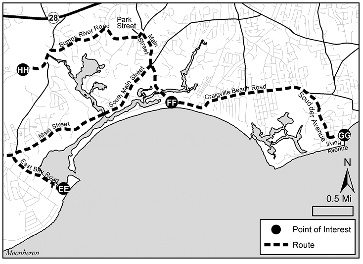
Section 7 detail.
Head south on Route 149 from the Marstons Mills airport and travel 2.8 miles to the junction of Route 28 near Marstons Mills Pond. Turn left at the light and in 0.7 mile take a right onto South County Road. Follow South County Road (which becomes Main Street) through the charming village of Osterville for 2.2 miles, then turn right onto East Bay Road. Proceed 0.7 mile to Dowses Beach (EE), one of the more interesting Nantucket Sound beaches in Barnstable. Waterfowl are often numerous and can usually be seen at close range. Common Goldeneyes may be joined by one or more Barrow’s Goldeneye. Brant forage along the front beach or in the channel into East Bay. Near the jetty or across the channel on the tip of Long Beach, you can often find wintering Ruddy Turnstones that are joined by Purple Sandpipers occasionally. Snow Buntings and “Ipswich” Savannah Sparrows are often found in the dunes or the parking lot. Historically, Dowses Beach has been a good spot for Black-headed Gull, either alone or in flocks of Bonaparte’s Gulls. The large thicket along the entrance road has held Yellow-breasted Chat.
Return to Main Street and turn right. In 2.2 miles, arrive at a four-way intersection with a stoplight, and turn right onto Craigville Beach Road. In 0.6 mile turn right into the parking lot of Craigville Beach (FF). Its most famous avian attraction is an Iceland Gull with almost pure white wingtips that has been returning annually. Seeing this bird is reason alone for the trip, but the area is also good for large numbers of waterfowl. Black-headed Gull has been found here numerous times. If you feel like taking a walk, you can drive 0.6 mile west of the main beach to Long Beach Road, which ends at a conservation area with a one-mile trail out to the tip of Long Beach, directly across the channel from Dowses Beach. This can be an enjoyable and productive walk, with the potential for Ruddy Turnstone and Purple Sandpiper at the tip. Park in one of the small lots just before the end of the road.
Leaving Craigville, follow Craigville Beach Road 1.9 miles and turn right onto Scudder Avenue in Hyannisport. In 0.4 mile, turn left onto Irving Avenue, and drive 0.3 mile to Eugenia Fortes Beach (GG). The enormous breakwater here may have Purple Sandpiper or small flocks of Dunlin, and the scrubby vegetation occasionally holds late songbirds. Wintering Palm Warblers have been found here on a few occasions. A flock of Common Redpolls visited the area in 2015. In 2020, a pair of overwintering Semipalmated Plovers was seen here as late as March.
For a change of habitat, check out Skunknett River Wildlife Sanctuary, a Mass Audubon sanctuary. To reach it, retrace your steps to the four-way intersection in Centerville, and head north on Main Street. In 0.4 mile, turn left at another four-way intersection onto Park Street, then almost immediately bear right onto Bumps River Road. Follow this winding road 1.4 miles to a small parking area on the right with a Mass Audubon sign. The trail leads in 0.5 mile or so to a loop around a beautiful, secluded pond, which has the distinction of being one of the best places on the Cape to find Northern Pintail. Most years at least a few are present, along with various other dabbling ducks. Skunknett is also a great place for owls, particularly Northern Saw-Whet Owl. Several significant stands of Atlantic white cedar provide excellent habitat for this appealing owl.
The diversity of habitats and unique possibilities for uncommon birds make the Upper Cape a great place to visit in the winter. To minimize travel, combine some of the sections into productive yet manageable birding trips. You can combine sections 1 and 2 into a full day of birding along the northern part of the Upper Cape, with the potential for a wide variety of species. Or follow the coastal Falmouth route in section 3, then head north to sections 4 and 5 to explore Mashpee and its range of birding possibilities. Finally, the ponds and coastal areas of Barnstable, highlighted in sections 6 and 7, offer the chance for many different species with minimal driving between hotspots. Any of the above routes will highlight the captivating beauty and wonderful winter birding potential of this memorable region of Cape Cod.
Peter Crosson is a physician and avid birder who lives in West Barnstable, Massachusetts. He is passionate about local-patch birding and enjoys discovering new hotspots in and around his town. When not birding, he enjoys time with his wife and two kids and their mini-schnauzer Sara.