Brian Vigorito
 The town of Pembroke, on the South Shore of southeastern Massachusetts, lies between Boston and Plymouth. It includes several large ponds and a number of small brooks that feed into the North River. Historically, this area was an important herring fishery for Native Americans and early European settlers, as well as the site of a major shipbuilding industry along the North River. In the more recent past, Pembroke was home to many cranberry bogs and a summer resort area called Mayflower Grove. Today, the town is primarily residential.
This article is divided in two sections. The first section—spring birding—covers two lesser-known places, Willow Brook Farm Preserve and Tubbs Meadow. The birding in these areas is typically at its best in the spring, so this section will focus on birding in May or June unless otherwise specified. Both areas have mostly flat, well-maintained trails and can be covered thoroughly in one to two hours each.
The second section—fall birding—covers Pembroke’s ponds, which are the town’s most popular destination for birders. Waterfowl arrive in the fall and linger through the winter, so this section focuses on birding in November or December unless otherwise specified. The shape and size of some of the ponds make it difficult to get a complete view from any one spot, so I have included multiple viewing locations for the larger ponds.
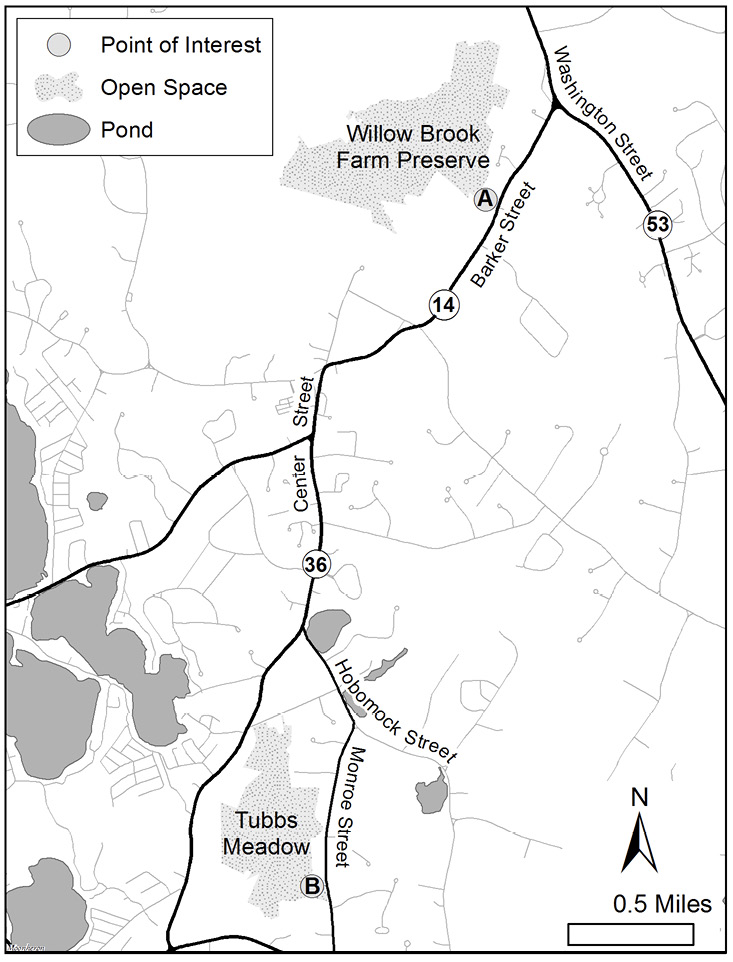
Figure 1. Spring birding map.
The fall birding trip is a single route covering all of the major vista points. Some of these access points have decent-sized parking areas that will be mostly empty in fall or winter, and others have room for only one or two cars on the side of the road. The north vista point for Little Sandy Bottom Pond and all vista points for Silver Lake require a short hike. You can bird all of the other ponds from or near your vehicle. It takes about four to five hours to cover the entire area in one trip. You can plan a shorter trip by visiting each pond only once—the best spot is listed first in each section—or by skipping the two smaller ponds, Little Sandy Bottom and Stetson ponds.
To plan a longer trip, you can combine several other nearby birding destinations with a visit to Pembroke to make a full day of birding. These include Burrage Pond Wildlife Management Area in Hanson, Mass Audubon’s Daniel Webster Wildlife Sanctuary in Marshfield, Duxbury Beach in Duxbury, and the Cumberland Farms Important Bird Area in Halifax and Middleborough. All four locations provide good year-round birding.
Blackpoll Warbler. All photographs by the author unless otherwise indicated.
SPRING BIRDING
Willow Brook Farm Preserve
Willow Brook Farm (Location A on Figure 1. Spring birding map) is made up of two former farms and a few smaller land parcels that are now owned by Wildlands Trust. About three miles of flat, easy trails pass through old farm fields, swamps, and mixed forest. An observation tower overlooks a large freshwater tidal marsh, a rare habitat in Massachusetts. To access Willow Brook Farm from Route 3, take Exit 27—Route 139 (recently renumbered from Exit 12) toward Hanover, follow Route 139 West for 1.1 miles, then turn left onto Water Street. In 1.0 mile, turn left onto Washington Street (Route 53 South). In 0.4 mile, bear right onto Barker Street (Route 14 West). After 0.5 mile, you will come to a small parking lot with a sign for Willow Brook Farm on your right. A trail map is available at <https://wildlandstrust.org/willow-brook-farm>.
From the parking lot, a single trail leads between two old cranberry bogs and then splits when you come out into a brushy field. Listen for the buzzing song of Blue-winged Warbler and look for Blue-gray Gnatcatcher flitting around in the treetops. Most of the fields are surrounded with thickets and mixed forest beyond. Eastern Towhee can be abundant along the edges of the fields, and Scarlet Tanager can be heard singing from the trees. At dawn and dusk in early spring, American Woodcocks display in these fields.
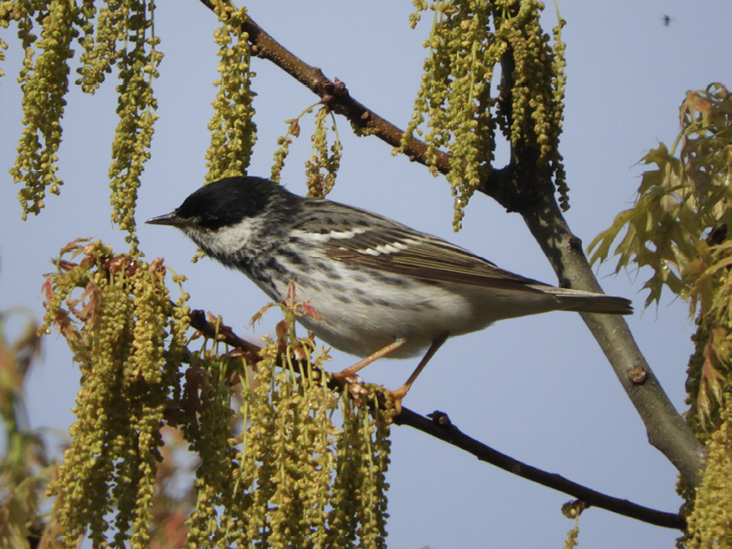
Veery.
At the split, follow the path on the right and walk straight toward the far end of the field. In another clearing farther down the trail, you will see several large piles of loose dirt, some several feet in diameter. I once encountered a hiker here who was concerned about these “shallow graves.” But have no fear; there are no bodies buried here. These piles are giant anthills created by Allegheny mound ants. The ants are not only responsible for building the mounds; they also maintain the grassy clearings around them. These ants have specific habitat preferences, and they kill saplings to prevent trees from overtaking the clearings.
When you reach the end of the field, the trail curves to the left. It passes through a small section of Atlantic white cedar swamp, takes you to the observation tower, then returns to the picnic table at the entrance to the large field to complete the loop. When you walk through the swamp, listen for the soft squeaky-wheel song of the Black-and-white Warbler, the emphatic teacher teacher teacher of the Ovenbird, and the nasal, fluting song of the Veery.
On a personal note, a singing Veery in this area was the spark bird that started my interest in birding. A few years ago, I would often go for walks at Willow Brook Farm and had begun keeping track of wildlife that I was seeing along the way. The song of a Veery immediately caught my attention even though I had no idea what it was at the time. Although this song is unique, it is also rather difficult to describe in words. I had to listen to a lot of bird songs to find one that matched so I could identify my mystery bird. For those unfamiliar with this song, one of my recordings is available at <https://macaulaylibrary.org/asset/246001611>.
The observation tower is a wooden platform about two stories high that overlooks the marsh. This a large open wetland where three small brooks join to form the North River. Although the North River is fresh water and runs for another 10 miles before reaching the ocean between Scituate and Marshfield, it is a tidal river; its water level and the marsh are affected by the tides.
The observation tower’s bench is a great place to sit and watch the birds coming and going. Swallows, herons, and the occasional Bald Eagle fly above the river. Cormorants and gulls also fly upriver during the spring when herring are running. The marsh attracts many warblers and other migrants. Because the tower is right in among the trees, sitting here quietly can reward you with a close view of a species normally only seen high overhead, such as Red-eyed Vireo or Blackburnian Warbler.
An interesting phenomenon occurs farther out in the marsh during fall migration. Migrating Soras stop in large numbers to feed on wild rice along the edges of the river. This species is normally seen only in ones or twos in Massachusetts, but a well-timed trip along the North River in late September can potentially turn up dozens. This requires getting out on the river in a canoe or kayak. A public boat launch on Indian Head Drive in Hanover provides access. Note that paddling on a tidal river comes with some practical and safety concerns that are beyond the scope of this article. The North and South Rivers Watershed Association has an excellent guide to such issues at <https://www.nsrwa.org/listing-category/paddling/>.
After you complete the loop around the field, you can access the northern half of Willow Brook Farm via the trail that branches off to the right about halfway across the main field. This trail leads across a boardwalk in a red maple swamp, crosses a bridge over Pudding Brook, and then loops around in a brushy meadow. There is also a connector trail here that leads to the Misty Meadows Conservation Area, owned by the town of Pembroke. The meadows have long since returned to forest, but you can still see the misty meadow effect at the horse farm on Route 53 around the corner from Willow Brook Farm. When conditions are right in the morning, fog condenses around Pudding Brook and fills the field.
Tubbs Meadow Conservation Area
The main entrance to Tubbs Meadow (B) is about 3.0 miles from Willow Brook Farm. When you leave Willow Brook Farm, turn right onto Barker Street, which shortly becomes Center Street. In the center of Pembroke, continue straight at the traffic light to stay on Center Street. After 0.8 mile, turn left onto Hobomock Street. In 0.4 mile, turn right onto Monroe Street. In another 0.7 mile, the large gravel parking lot for Tubbs Meadow will be on your right. Trail maps are available at <http://southshoretrails.com/tubbsmeadow/> and <https://www.pembroke-ma.gov/sites/g/files/vyhlif3666/f/uploads/map_of_trails_in_tubbs_meadow.pdf>.
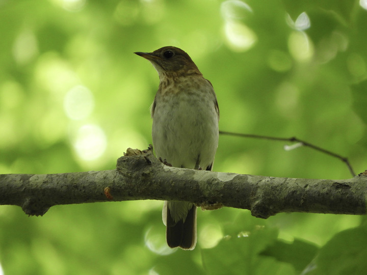
Pectoral Sandpiper.
Tubbs Meadow is made up of former cranberry bogs that are now conservation land owned by the town of Pembroke. Some of the bogs are completely flooded and have become small ponds, and others have been almost completely taken over by secondary forest. A couple of miles of broad, dirt trails provide easy access to the entire area.
The main trail from the parking lot leads through a small section of woods and soon comes out into an open area near four small ponds, broken up by old dikes from the cranberry bogs. The dikes are just wide enough for a narrow strip of vegetation to grow on either side of the path, making it easier to spot birds here than in the dense woods. Look for warblers, orioles, and Rose-breasted Grosbeaks.
West of the ponds is a large section of pine forest. The trail here leads off to a side entrance in a neighborhood and does not connect back to the rest of the area. But it can be worth a quick walk down and back to listen for singing Ovenbird and Hermit Thrush.
North of the ponds is a sandy area where the small trees and shrubs have begun to reclaim the bogs. Look for Field Sparrow and Eastern Bluebird here. Along the edge of this area, there is an east-facing slope that runs up to a residential neighborhood. This can be a great place to look for warblers and other migrants when the sun hits the slope early in the morning. Farther north, the trail winds past a small pond, then goes through another section of young forest. The path here connects to a side entrance with a few parking spots on Mill Street.
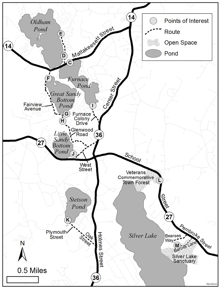
Figure 2. Fall birding map.
Tubbs Meadow tends to be at its best in the spring, but it can also be worth a visit at other times of year. In late summer and early fall, the ponds can dry up, leaving a lot of exposed mudflats that attract Pectoral Sandpiper, Least Sandpiper, and other shorebirds. Later in the fall, various sparrows can be found in the sandy area, and dabbling ducks arrive on the ponds.
FALL BIRDING
Pembroke Ponds
To reach the Pembroke ponds (See Figure 2. Fall birding map) from Route 3, take Exit 27—Route 139 toward Hanover and follow Route 139 West for 1.1 miles, then turn left onto Water Street. In 1.0 mile, turn left onto Washington Street (Route 53 South). In 0.4 mile, bear right onto Barker Street (Route 14 West). After passing Willow Brook Farm, Barker Street becomes Center Street. In 1.0 mile, bear right in the center of Pembroke onto Mattakeesett Street (Route 14 West). After another 1.5 miles, the road passes between the first two ponds.
The parking lot of the Lucky Dawg Tavern (C) will be on your left and is a good spot to stop and look at Furnace Pond. The restaurant is located on a small point of land that juts out into the pond, and the parking lots on both sides of the building look onto different sections of the pond. To the left, a shallow cove in the northeast corner of the pond attracts dabbling ducks and American Coot. To the right, a larger, more open section attracts scaup and other diving ducks.
The northwest corner of the pond can be hard to see from the parking lot, but there is another vista point a little farther west on Mattakeesett Street. Walk a bit down the sidewalk to a small trail leading to the water’s edge directly opposite Wampatuck Street. The far southern end of Furnace Pond is quite distant from here and partially obscured, but another vista point is included later.
Return to the Lucky Dawg parking lot and take a left on your way out, then immediately take the next right onto Wampatuck Street. The Pembroke Town Landing (D) will be just ahead on your left. This area includes a small beach and a boat ramp with a parking lot. Pull in here for the best view of Oldham Pond.
Set up your scope in the parking lot and scan for Common Goldeneye, scaup, and other diving ducks. In addition to the typical diving ducks, one unique individual has been seen in this pond over the last few years. A drake Common Goldeneye x Hooded Merganser hybrid has returned to Pembroke every fall since 2017. This stunning duck is most often seen on Oldham Pond but could be found on any of the ponds in the area. Besides being a beautiful animal on its own, this individual also demonstrates the tendency of ducks to form unusual hybrid pairings. Its parents are not only from two different species, they are not even in the same genus.
A small plastic dock sticks out into the water next to the boat ramp. Walking out on the dock gives you a view of the close shore. Dabbling ducks and American Coot may be seen feeding among the reeds.
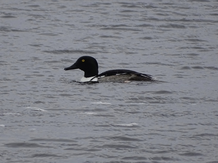
Common Goldeneye x Hooded Merganser. Photograph by Jim Sweeney.
If the rafts of ducks at the north end of the pond are too far out of sight, you can try another access point. Drive north on Wampatuck Street and take a left onto Adams Avenue. On your left across from Beebe Lane there is a small playground and beach (E) with a few parking spots along the side of the road. From here, you can get a closer view of the northern half of Oldham Pond, including the northwest corner, which is hidden behind an island when looking from Town Landing.
Head back on Adams Avenue and Wampatuck Street to return to Mattakeesett Street, turn right, and in 0.4 mile take the second exit at the rotary to stay on Mattakeesett Street. About 500 feet south of the rotary, there will be a dirt pulloff (F) on your left. Pull in here for the first vista point at Great Sandy Bottom Pond.
Great Sandy Bottom Pond is one of the best places in Plymouth County to see Ruddy Duck. In late fall, as many as four to five hundred can gather here along with other diving ducks. The pulloff from Mattakeesett Street typically provides the closest views of the Ruddys, but much of the pond may not be visible from this angle.
A small trail through the woods leads down to the edge of the pond. The water level here can vary quite a bit. If the water is high, you may have to look from the end of the trail, and only the cove in the northwest corner will be visible. Sometimes there is enough exposed shoreline to walk to the right and get a view of the northeast corner, where the largest rafts of ducks tend to congregate.
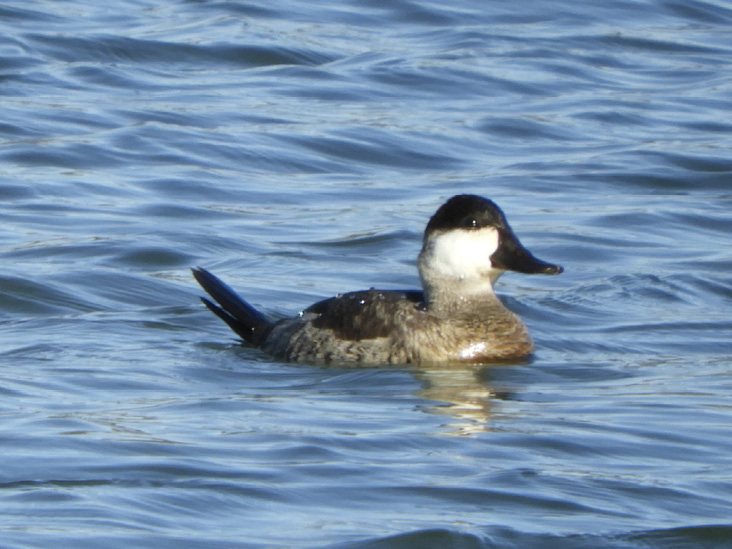
Ruddy Duck.
To see the southern end of Great Sandy Bottom Pond, continue south on Mattakeesett Street and take the first left onto Fairview Avenue. In 0.4 mile, at the end of Fairview Avenue, take a left into the wooded area on Glenwood Road. After about 500 feet, you will arrive at an open area, and there will be an unmarked dirt road on your left. There is no sign here, but the dirt road is Ridge Avenue. Take a left onto Ridge Avenue, and park in the dirt pulloff (G) where the road widens.
On the north side of the dirt road, an overgrown trail leads to the water’s edge at the southern end of Great Sandy Bottom Pond. From this vista point, you can see most of the pond. When the water level is high, this may be the best option to see into the northeast corner. This is also a better vista point in the morning, as glare from the rising sun may make it hard to see from the first pulloff.
On the south side of the dirt road, there is a sandy area with brushy habitat and an old cranberry bog. Check the thickets for sparrows, Northern Mockingbird, and the occasional Brown Thrasher. If there is water in the bog, check for Green-winged Teal, other dabbling ducks, and perhaps a lingering shorebird.
This area is also well worth a visit at other times of year. In spring, when warblers and other migrant songbirds are arriving, Ruddy Ducks are leaving our area. Small numbers will often linger on Great Sandy Bottom Pond into mid-May, providing an opportunity to see their vibrant breeding plumage, with adult males sporting light blue bills and reddish brown bodies.
In late summer and early fall, shorebirds and waders use the small bog south of the pond as a stopover site. Several species of sandpipers, including Pectoral, Solitary, and Spotted, often can be found here together, as well as Semipalmated Plovers and Killdeer. These shorebirds will also use the exposed shoreline around the edges of Great Sandy Bottom Pond if the water level is low. Great Blue Heron, Great Egret, and Snowy Egret can pack into this small bog in surprising numbers, with the occasional Little Blue Heron, Glossy Ibis, or night-heron mixed in.
Turn around and head back to Glenwood Road. Take a left onto Glenwood, then immediately pull into the small parking lot on your right, across the street from the Pembroke Water Department. This parking lot also provides another vista point to look down into the bog behind Great Sandy Bottom Pond.
The area west of Glenwood Road is known as Windswept Bogs (H); several trails here crisscross former cranberry bogs, which are slowly giving way to secondary forest. In a good winter for finches, this area is worth a thorough check. The mix of birch trees, crabapples, and pines is perfect for attracting Common Redpoll, Purple Finch, and Pine Siskin. In other years when the finches stay north, you can still find American Tree Sparrow, Dark-eyed Junco, and kinglets here.
Little Sandy Bottom Pond is at the south end of Windswept Bogs. The broad, dirt walking trail leading south from the parking lot will take you to a small, public beach on the shore. Bring your scope to check for Bufflehead, Common and Hooded merganser, and Common Goldeneye.
Walk back to your car. When you exit the parking lot, turn right to continue south on Glenwood Road, which becomes Toole Trail. After about 0.5 mile, take a left onto West Street. At the end of the road, take a left onto Center Street (Route 36 North). After another 0.5 mile, take a left onto Furnace Colony Drive. In 0.25 mile, there will be a few parking spaces for Furnace Pond Beach (I) on your right. This is the same pond visible from the first stop at Lucky Dawg Tavern, but this beach provides a view of the southern half, which cannot be easily seen from the earlier stops.
Retrace your route and return to Center Street. Take a right onto Center Street and then another right onto West Street. In 0.5 mile, take a right onto Shepard Avenue. At the end of Shepard Avenue, there are a couple of parking spots at another small beach (J), which gives a different view of Little Sandy Bottom Pond.
Return to West Street and take a right. At the end of the road, take a left onto School Street (Route 27 East). Take a right at the first traffic light onto Center Street (Route 36 South). In 1.5 miles, take a sharp right onto Oak Street, which becomes Plymouth Street in 0.5 mile; continue straight. Shortly, you will come to a parking lot for Stetson Pond Beach (K) on your right.
This is the only publicly accessible vista point at Stetson Pond, but luckily you can see the entire pond from the parking lot here. Across the street in the woods, there is another shallow pond known as Chaffin Reservoir. There is no trail here, but if you are up for a short bushwhack, this pond can be good for Wood Duck and other dabblers.
Retrace your route and follow Routh 36 North back to Route 27. Take a right at the traffic light onto School Street (Route 27 East). Follow School Street for 1.2 miles. The parking lot for Veterans Commemorative Town Forest (L) will be on your right, just after you pass Lake Street on the left.
This area provides access to Silver Lake, which is located in Pembroke and the neighboring towns of Halifax, Plympton, and Kingston. There are no roads or parking lots along the shore; all of the vista points described here will require a short hike. A trail map for this area is available at <http://southshoretrails.com/veteranstownforest/>. From the parking lot at the town forest, follow the main trail for about 0.5 mile to reach the northeast shore of Silver Lake. If the water level is high, the only view here may be from the end of the trail. When the water level is lower, it is possible to walk around on the shoreline.
Of all the ponds in the area, Silver Lake often has the greatest diversity of waterfowl, attracting both diving and dabbling ducks, as well as geese and swans. Large numbers of Common Goldeneye often can be found here, with the occasional Barrow’s Goldeneye mixed in. Because it is one of the largest bodies of the water in the area, many waterfowl roost here overnight. It can be worthwhile to visit Silver Lake in the late afternoon and watch ducks flying in from some of the smaller ponds.
When you leave the parking lot, turn right onto School Street. After about 1.5 miles, you will pass Bearses Way on the right. Immediately after Bearses Way, there is a small dirt road into the woods named Barses Lane (M). Turn right onto Barses Lane. After about 0.3 mile, you will come to a loop in the road and an old barn. There is a dirt parking lot just past the barn at the trailhead for Silver Lake Sanctuary. (Note: do not rely on Google maps or GPS devices in this area. Barses Lane does not appear on online maps, and the paved road, Bearses Way, does not connect to this parking lot.) A full trail map is available at <http://kplma.org/maps/SLSS_MapG.pdf>.
From the kiosk at the trailhead, there are two paths to the shoreline. The trail to the right of the kiosk leads to a vista point near the middle of Silver Lake that provides a good view of most of the lake. At the fork near the beginning of this trail, bear left and go straight ahead for about 0.25 mile to reach the shoreline.
To the left, behind the kiosk and the barn, a longer trail leads to a cove at the south end of the lake. Continue straight at the first intersection and walk for about 0.25 mile. When the trail splits, bear right. The trail curves around a swampy area and after 0.25 mile, it comes out onto a small beach, which is the third and final vista point for Silver Lake.
Reference
- McCook, Henry C. 1877. Mound-Making Ants of the Alleghenies, Their Architecture and Habits. Transactions of the American Entomological Society 6: 253–96. JSTOR, http://www.jstor.org/stable/25076323. Accessed 1/11/2021.
Brian Vigorito has lived in Pembroke with his wife Elizabeth since 2010. He first became interested in birds while volunteering for Wildlands Trust in 2016 and has been an avid birder ever since. He is an active member of the South Shore Bird Club and leads trips for the club.