Steven Lamonde
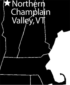 If you have searched for Golden-winged Warblers (Vermivora chrysoptera) in Vermont, chances are you have probably heard of Geprags Community Park in Hinesburg. This is arguably Vermont's most famous site to see Golden-winged Warblers, Blue-winged Warblers (Vermivora cyanoptera), and their hybrids, collectively known as the "winged-warbler" or Vermivora complex, after their genus name. Roughly 93% of winged-warblers reported to eBird in Vermont are documented at, or south of, Geprags Community Park, which has left the northern end of the Champlain Valley, the area above Burlington and west of the Green Mountains, underexplored. While over 90% of the northern Champlain Valley is privately owned, four publicly accessible locations annually host breeding winged-warblers: Colchester Pond Natural Area (Colchester), Aldis Hill and Hard'ack Recreation Area (St. Albans), Maquam Wildlife Management Area (Swanton), and Rollo and Ballard roads (Highgate).
It is best to visit these places between the latter half of May and June, when winged-warblers are easiest found. The warblers arrive in Franklin County as early as the first week of May, and springtime detections of these birds peak in the last two weeks of May. They continue to sing through June, gradually decreasing in how often they sing and eventually falling silent during the first two weeks of July, adding substantial challenge to locating them. While difficult to observe, these birds stay another month in the region, taking time to raise young and prepare for fall migration. Virtually all winged-warblers leave northern Vermont by mid-August, having spent two-and-one-half to three-and-one-half months on their breeding grounds.
On any given day between mid-May and the end of June, you can best hear winged-warblers during the dawn chorus, which ranges from about 30 minutes before sunrise to three to four hours after sunrise. However, winged-warblers have been detected as early as 4:00 am and as late as 8:30 pm, so if you are running behind schedule it is not impossible to find them later in the day. Regardless of time of day, ticks, mosquitoes, and black flies are ubiquitous across the northern Champlain Valley May through July, so pant legs tucked into socks and insect repellent are recommended at all four sites.
Map 1. Northern Vermont Overview
Colchester Pond Natural Area, Colchester
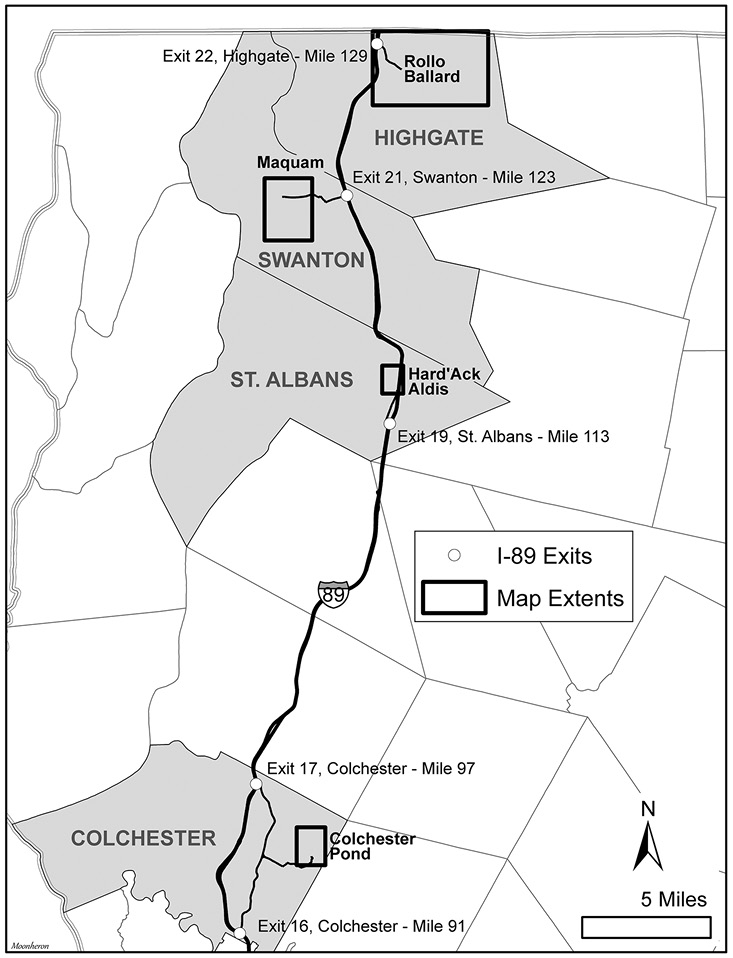
Directions: From Interstate 89 (I-89), take Exit 17 if you are coming from the north or Exit 16 if coming from the south. Whichever exit you take, get onto US-2 heading toward VT-2A. This will be US-2 West from Exit 16 and US-2 East from Exit 17. Not more than 0.25 mile after turning on to Main Street/VT-2A East, you will pass The Village Scoop ice cream shop on your left. Keep this place in mind for a congratulatory treat after birding for winged-warblers at Colchester Pond. Continue driving on Main Street for 0.8 mile, and turn left (north) on East Road. After 0.6 mile, take the first right onto Depot Road, which becomes Colchester Pond Road near DJ's Tree Service & Logging business on the left. Pass over the railroad tracks, and continue for 0.3 mile, keeping left at the split to stay on Colchester Pond Road. After the split, continue another 0.2 mile, and take the first slight right to enter the access road to the parking area (44.550796, -73.125110).
Map 2. Colchester Pond Natural Area.
Owned by the Winooski Valley Park District, the 693-acre Colchester Pond Natural Area attracts hundreds of visitors each year. Fishing, hiking, dog walking, and wildlife watching are popular activities along the three-mile trail that encircles the park's 182-acre namesake, Colchester Pond. Nearly 200 bird species have been documented on the property, which boasts good avian diversity year-round. In winter, Northern Shrike, American Tree Sparrow, and overwintering Eastern Bluebird occur regularly. In spring migration, grebes and shorebirds are not uncommon, and more than 25 warbler species can be found. From June through July, some 120 bird species breed in the property's diverse habitat, including Caspian and Common terns, American Bittern, Bald Eagle, Red-shouldered Hawk, Eastern Meadowlark, and Scarlet Tanager. Fall migration is particularly good for waterfowl; Tundra Swan, Long-tailed Duck, and Red-breasted Merganser have been highlights in recent years.
Although the trail completes a three-mile loop around the pond, the winged-warbler habitat is located within 0.4 mile of the trailhead. From the parking lot, head east toward Colchester Pond, following the trail downhill. Just before the dock at the end of the trail, turn left under the power lines. From here, the trail continues just under 0.25 mile along the west shore of Colchester Pond. After passing a tree line on the left-hand side of the trail, turn uphill through the hayfield to the power line, about 120 yards away. Take care to stay close to the tree line to reduce the risk of stepping on a Bobolink or Savannah Sparrow nest, since they prefer nesting toward the center of a field.
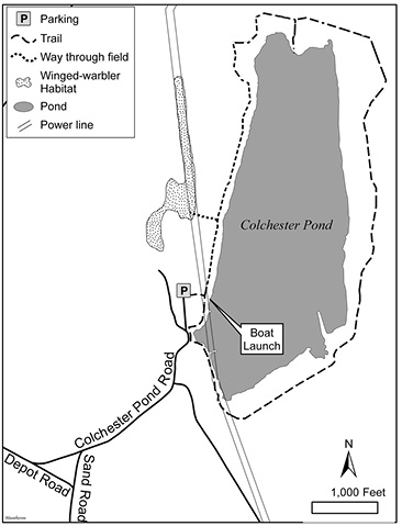
Ideal winged-warbler habitat contains a mixture of herbaceous ground cover, dense scrub/shrub, interspersed young trees, and adjacent mature deciduous forest. All photographs by the author.
Under the power line, you will see an ATV trail for power line company employees, which you can follow north under the power line. You can find winged-warblers, Prairie Warblers, Field Sparrows, Indigo Buntings, and other scrub/shrub-dwelling birds along the first 0.4-mile of this trail before the scrub/shrub transitions to mostly herbaceous cover. From the start of the scrub/shrub habitat at the edge of the field, winged-warblers can also be found to the west and southwest. There are not trails through this section of habitat west of the power line, but the vegetation is sparse enough in some areas for relatively easy passage if you would prefer to walk around rather than conduct a stationary point count to listen for winged-warblers. It could take as little as 15 minutes from leaving the car to detect a winged-warbler, but an hour or two would not be unexpected if wind, precipitation, or time of day is against you. The recommended time is 40 minutes to 2 hours, longer if you want to go around the pond.
Aldis Hill and Hard'ack Recreation Area, St. Albans
Directions: From Interstate 89, take Exit 19 toward St Albans/US-7/VT-104. Leaving the exit ramp, take the first right to head north on VT-104. You will pass a Maplefields store and gas station on the right as you make the turn. Drive north 1.2 miles, and turn left (west) onto Congress Street. If you find yourself driving over the Interstate, you have gone too far. Once on Congress Street, take your first right (north) to enter Hard'ack recreation area. The entrance is paved with gravel, and parking (44.813342, -73.064462) will be on your right across from the dog park.
The combined property of Aldis Hill (130 acres) and Hard'ack Recreation Area (100 acres) sits in the northeast corner of St. Albans, just west of I-89. A local historical gem, the park has a small tow-rope ski and sledding hill that began operating in the 1960s, as well as a stone monument memorializing the site where the last gray wolf in Franklin County was killed in 1839. A six-mile maze of unmarked trails traverses Aldis Hill. These trails are used by hikers, mountain bikers, and cross-country skiers. eBird lists 88 species for the park, yet fewer than 50 eBird checklists have been submitted here to date. Rough-legged Hawks, Brown Thrashers, Bohemian Waxwings, Mourning Warblers, and, of course, the Vermivora warblers are highlights at this location. No doubt this property list will continue to grow the more often birders visit.
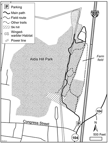
Map 3. Aldis Hill and Hard'ack Recreation Area.
The best winged-warbler habitat at Aldis Hill and Hard'ack Recreation Area is limited to a roughly nine-acre area just north of the park. Most of this prime habitat is on private property; however, the southern end dips into the park and is accessible from some of the park's trails. Additionally, you can sometimes find winged-warblers using the power line corridor that stretches 0.5 mile north from the ski slope. To reach this area from the parking lot, follow the gravel road north past the gate, and continue until you reach the ski slope. Keeping the power lines above you and the hum of vehicles on I-89 to your right, enter the trail system and head north. Do your best to stay in or near the power line, and keep walking north until the trail reverses sharply to the south and there are no other trails heading north from this point (44.822739, - 73.065295). This is the best location within the power line corridor and on a trail to find winged-warblers. For more adventurous seekers, a game trail meanders north from the mowed path. You can follow it for several dozen meters, getting closer to the prime habitat roughly 400 feet farther north.
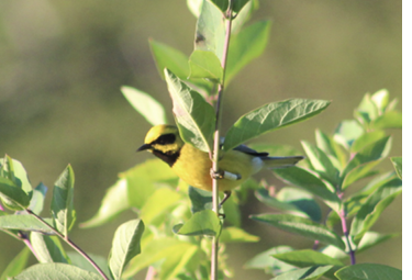
Pure Golden-winged and Blue-winged warblers have been documented at Aldis Hill, as well as the more common Brewster's Warbler hybrid and this rarer Lawrence's Warbler hybrid.
Alternative to heading off-trail, you can sometimes hear winged-warblers from the western edge of the northernmost field of Hard'ack Recreation Area. To get here from the power line corridor, head east toward the highway, then take the first left. Follow this trail around the field, back toward the power line. The tall, unmanicured hedgerow at the western edge of this field can make viewing into the winged-warbler habitat difficult, so be sure to listen as best as possible. Traffic noise from the highway can be challenging, so birding from this spot is recommended outside of morning commute times or on weekends. Fortunately, birding within the power line and forest is easier because the tall vegetation better blocks sound from the highway. All told, you need about an hour to secure a good chance of detecting a winged-warbler on the suggested trails and two to four hours for the entire park.
Maquam Wildlife Management Area, Swanton
Directions: From Interstate 89, take Exit 21 onto First Street/VT-78 West, and drive 0.8 mile into downtown Swanton. At the intersection across from the village green, take a right onto Grand Avenue and continue, following signs for VT-78. Cross the bridge of the Missisquoi River, and turn left onto South River Street. After a short 350 feet, take the first right onto VT-36/Lake Street, and continue for 1.4 miles. There is room for one car to park (44.920641, -73.160092) on the south side of Lake Road across from Lasnier Road, but some feel it is easier to park at the boat launch (44.920762, -73.156938) 0.1 mile farther down the road.
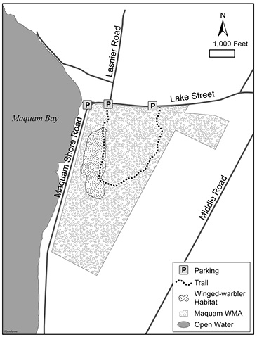
Map 4. Maquam Wildlife Management Area.
Currently managed by the Vermont Fish and Wildlife Department, this state-owned land was first purchased in 1953, and additions have been acquired as recently as 2002. Prior to European settlement, the Missisquoi band of the Abenaki tribe called this area home. Beaver, or maquam in Algonquian, can still be found in the northern part of the Maquam Wildlife Management Area (WMA), which lies north of route VT-36. The southern Lampman parcel consists of 482 acres of upland forest, patches of which are managed for American Woodcock, Ruffed Grouse, and white-tailed deer. Hunting is allowed at the WMA, but the only season that overlaps with winged-warbler breeding is the turkey season, May 1–31.
Some 124 bird species have been documented to eBird at Maquam WMA, a hotspot it shares with Swanton Town Beach, which is located across VT-36 from the northwest corner of the management area. A well-maintained boat launch offers good views of waterfowl and shorebirds during spring and, especially, fall migration. Black Terns have been reported along the shore of Lake Champlain south and north of the beach, and this species is an expected next addition to the location list. Within the WMA itself, the songbird mix is typical of northern hardwood forests. What sets this site apart from similar-looking places east of the Green Mountains is the presence of winged-warblers.
To access the WMA from the parking spot or boat launch, head south past the gate and down the slightly overgrown trail. Long pants and insect repellent are strongly recommended when exploring this ungroomed trail because biting insects can be expected. About 0.2 mile from the gate, the trail passes through several re-foresting clearings, each of which possesses suitable habitat for winged-warblers: herbaceous groundcover, scrub/shrub bushes, and adjacent deciduous forest. Winged-warblers establish territories along this 0.5-mile section of trail, which eventually turns west and north back toward VT-36. This eastern half of the trail can be wet in the spring and is difficult to follow in some sections due to the amount of overgrowth. No clearings or patches of early-successional forest are present to support winged-warblers on this eastern half of the WMA, but other warblers, flycatchers, thrushes, tanagers, woodcocks, and grouse are plentiful. While just 30–40 minutes are recommended for finding winged-warblers at Maquam WMA, a full 1.5–2.5 hours allows for birding the entire trail loop and boat launch.
Rollo Road and Ballard Road loop, Highgate
Directions: From Interstate 89, take Exit 22, the last exit on I-89 before Canada. Make a right at the end of the exit ramp onto VT–7 South, and follow this for 0.7 mile before turning left onto St. Armand Road. Pass the Rock River Wildlife Management Area and associated marsh, and continue for 0.7 mile until you reach Ballard Road on your left. This intersection (44.993983, -73.066170) marks the start of the driving loop.
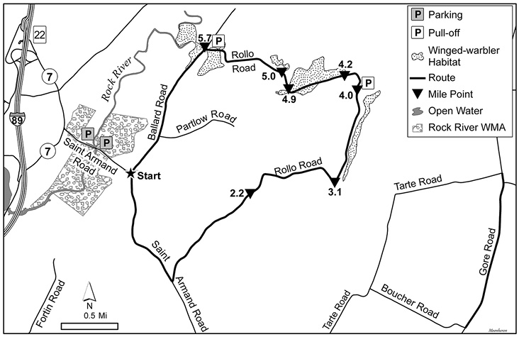
Map 5. Rollo Road and Ballard Road loop.
A mere 2,000 feet from the international border with Canada, this location is the northernmost site in Vermont where winged-warblers can be found with some regularity. Although neither public lands nor exceptional pull-off parking spots exist along Rollo Road and Ballard Road, the 7.1-mile driving loop presents suitable early-successional habitat close to the roadway, and automobile traffic is minimal due to the rural setting.
From the starting intersection of St. Armand Road and Ballard Road, you have the choice of driving north along Ballard Road or continuing straight on St. Armand Road and taking the first left onto Rollo Road. If time is limited, head north 1.3 miles to the intersection of Ballard and Rollo roads. This area, particularly the first 600 feet south of Rollo Road, is the best location for winged-warblers along the route. If you have 90 minutes on hand, birding the full loop is recommended. A good morning during the third or fourth week of May can yield more than 60 species of birds. The following directions and distances apply to driving the loop clockwise from the starting intersection.
Reset the trip odometer on your car at the intersection of St. Armand and Ballard roads. Drive 1.1 miles to Rollo Road, which will be on your left. Turn onto Rollo Road, passing several houses on both sides of the street. Be sure to check the feeders and yards for songbirds. Next, drive through a 0.6-mile stretch of forest. Wood Thrushes, Veerys, pewees, forest flycatchers, warblers, Baltimore Orioles, and Scarlet Tanagers all can be heard in this section. At 2.2 miles, Rollo Road opens to fields on both sides of the road, and a small pond is on the left. You can pick up some ducks and Great Blue Herons here. Drive around several bends in the road until it turns sharply left at 3.1 miles. The winged-warbler section of Rollo Road begins here and continues for 2.6 miles until you reach the intersection with Ballard Road.
As you drive this relatively straight section of Rollo Road, stop frequently for at least five minutes at a time to listen for winged-warblers along the east side of the road. At 4.0 miles, you will pass a farm on the right. Here, the winged-warbler habitat bordering the tree line to the east moves farther away from the road. However, at 4.05 miles, the road widens on the uphill just past the farm, allowing for a good pulloff to enjoy a view to the east over the farm. If the farm is not busy, this is a good place to scan the skies and fields for raptors, swallows, and grassland birds. Beyond the farm and around a bend to the left, another patch of winged-warbler habitat comes into view on the right side of the road. With the morning sun at your back on the last 1.5 miles of Rollo Road, lighting is ideal for photographing winged-warblers and other creatures near the road. Several stops are recommended between odometer readings 4.2–4.9, with another stop at 5.0 miles, where Rollo Road crosses a stream.
Continue until you reach the T-intersection with Ballard Road. There is room near the intersection to pull off the road to park. Getting out of the car here for 20–30 minutes is worthwhile. There is good winged-warbler habitat from the intersection to 600 feet back up Rollo Road as well as 600 feet south along Ballard Road. You can hear and see Bobolinks, Savannah Sparrows, and sometimes Eastern Meadowlarks in the hay fields north and northwest of the intersection. This spot concludes the Rollo Road and Ballard Road loop. If time allows, you will be rewarded by a nearby stops in Highgate at Rock River WMA and Gore Road. Rock River WMA boasts Least and American bitterns, Soras, Virginia Rails, and the odd Common Gallinule; Gore Road is one of the few places in Vermont that Upland Sandpipers can be found reliably. The section between Boucher Road and Tarte Road is most productive.